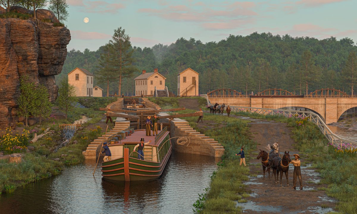
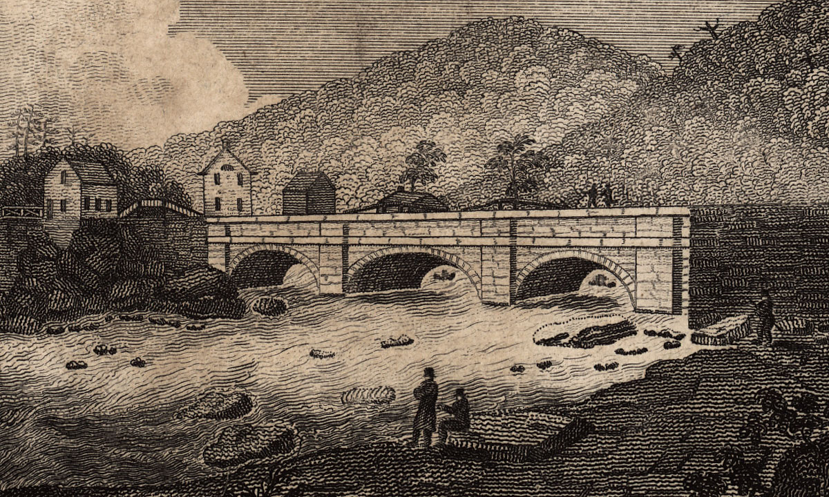
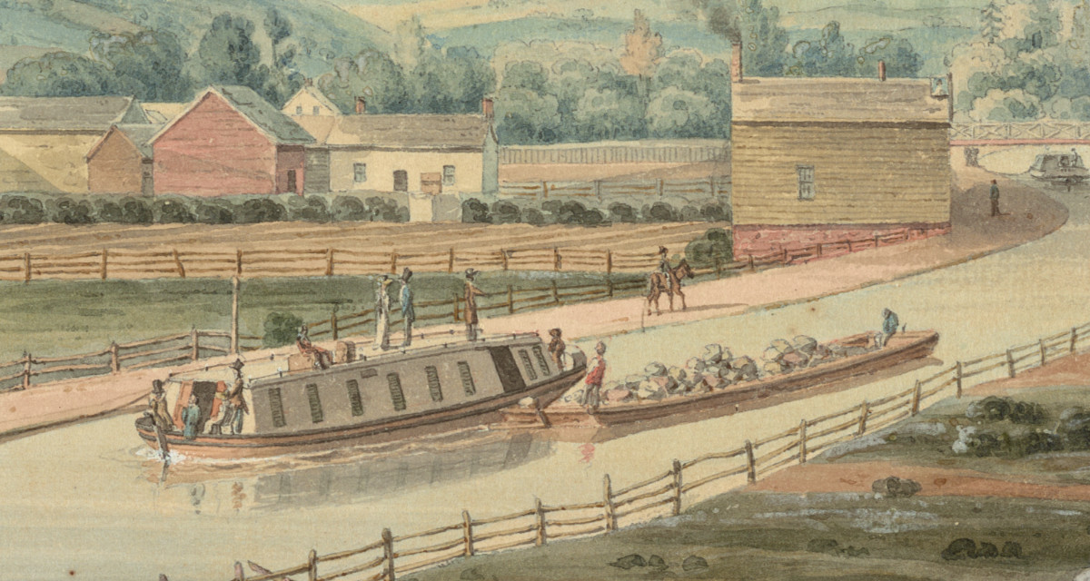
Early morning, Sept. 8, 1824, looking west toward the Little Falls Aqueduct, with the Mohawk River gorge on the right. (Digital image copyright 2021 by Steve Boerner)
It’s been a long and interesting trip, but the Little Falls scene is finally finished.
This picture is meant to show a few things.
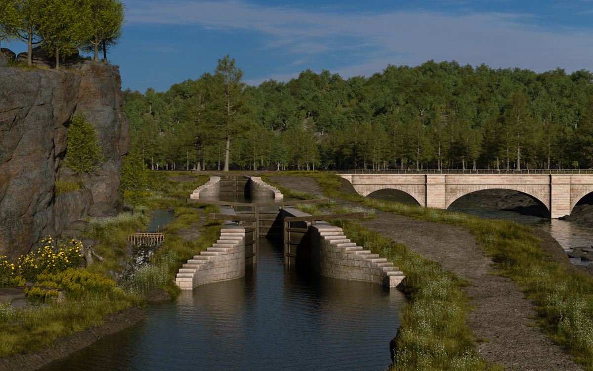
First, the technical challenge of surmounting the 40-foot height of the rapids at Little Falls. That was accomplished by a series of five locks, two of which were placed in quick succession and are shown here.
Second, the Little Falls Aqueduct, which was constructed partly to solve the political problem created when surveyors located the new canal on the south bank of the Mohawk River, potentially isolating the village of Little Falls on the north bank. This compromise resulted in one of the iconic locations of the early canal, a scene repeatedly depicted by artists throughout the 19th century.
Little Falls itself was beginning a rapid growth spurt, represented by the cluster of buildings in the distance.
This part of the canal was completed and successfully watered late in 1823. Passenger service began in earnest the following spring, when four packets operated by the Utica and Schenectady Packet Boat Company began running regular schedules between those two cities. One of the boats is included here.
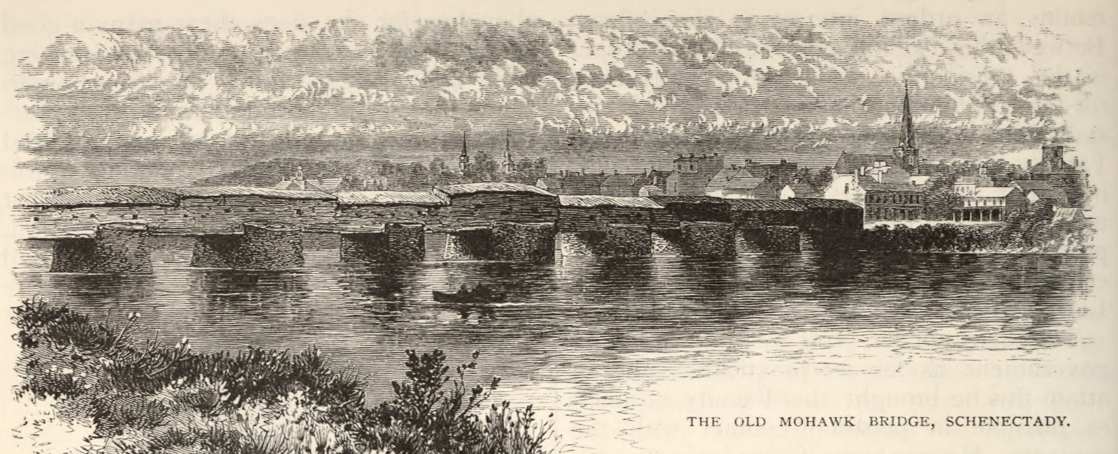
Then there was the surprisingly difficult challenge of digging up information about the road bridge across the Mohawk. The three-arched wooden bridge shown here, partially visible behind the aqueduct, represents an educated guess as to how it might have looked.
Finally, the early-morning activity will hopefully show just how busy this little place was. Soon the canal would be open along its entire length and things would get even busier. Between 1824 and 1918 the canal would be enlarged, and then enlarged again, and then again. Little Falls, its historic river, and the picturesque gorge would never be the same.
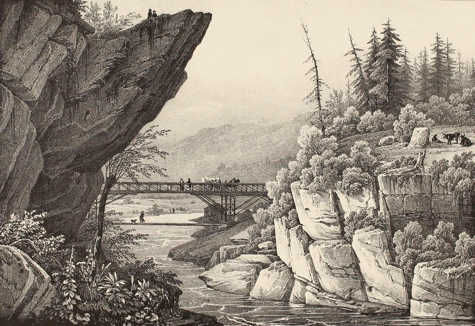
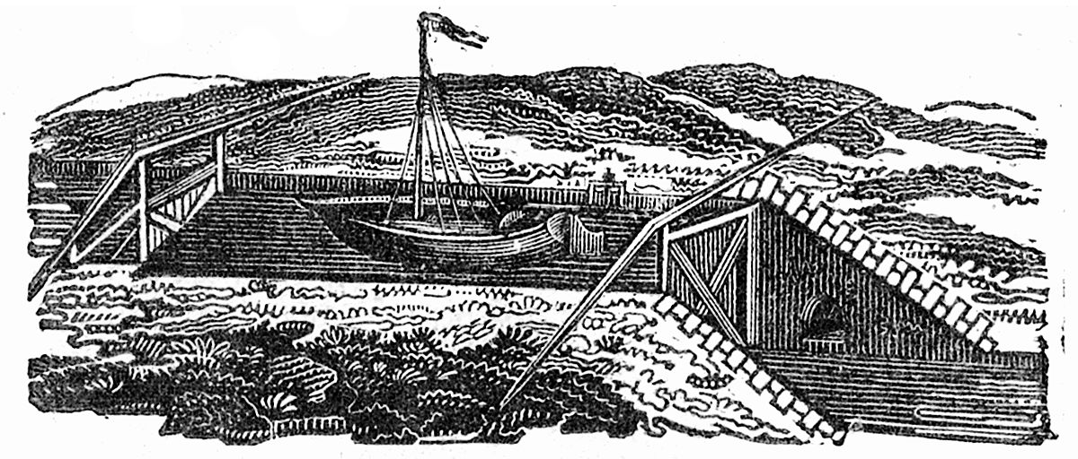
The carpenter-engineers of the New York frontier experimented with many different bridge designs. This wooden truss, erected across the upper Hudson River, is one example. (Jacques-Gerard Milbert, “Picturesque Itinerary of the Hudson River and the Peripheral Parts of the United States.” Columbia University Libraries via Internet Archive)
The early 19th century was an era of bridge building in the young United States.
White settlers were pushing their way across the Appalachians and the need for dependable overland transportation routes was becoming ever more urgent. Grain and raw materials needed to be sent to markets back east. Tools and other manufactured goods were ready to be shipped west.
State legislatures, wary of spending tax dollars on public infrastructure, instead encouraged private companies to build roads and bridges. In New York, dozens of companies were formed to build turnpikes for which they could charge tolls and, hopefully, turn a profit. Bridges would be needed to span the Hudson, Mohawk, Delaware, and myriad smaller streams and rivers that got in their way.
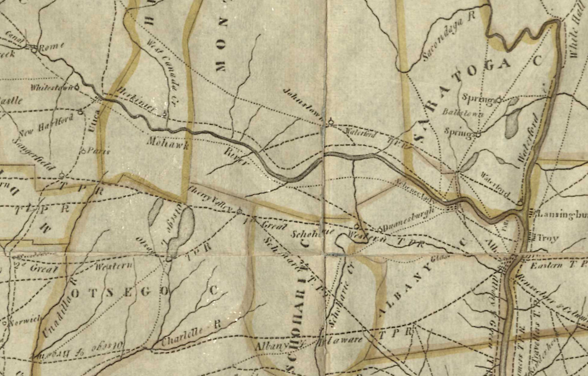
A network of turnpike roads crisscrosses central New York in this map, published in England in 1808. (New York State Library)
There were no professional engineers in those days, so mechanics, millwrights and carpenters stepped up to design and build those bridges. Their preferred construction material was timber, of which the forests provided an endless supply.
Their efforts were not scientific. Instead they relied on experience and common sense. In the long run, a handful of these carpenter-engineers would revolutionize bridge building and lay the foundations of American structural engineering.
The little community of Little Falls was there at the beginning.
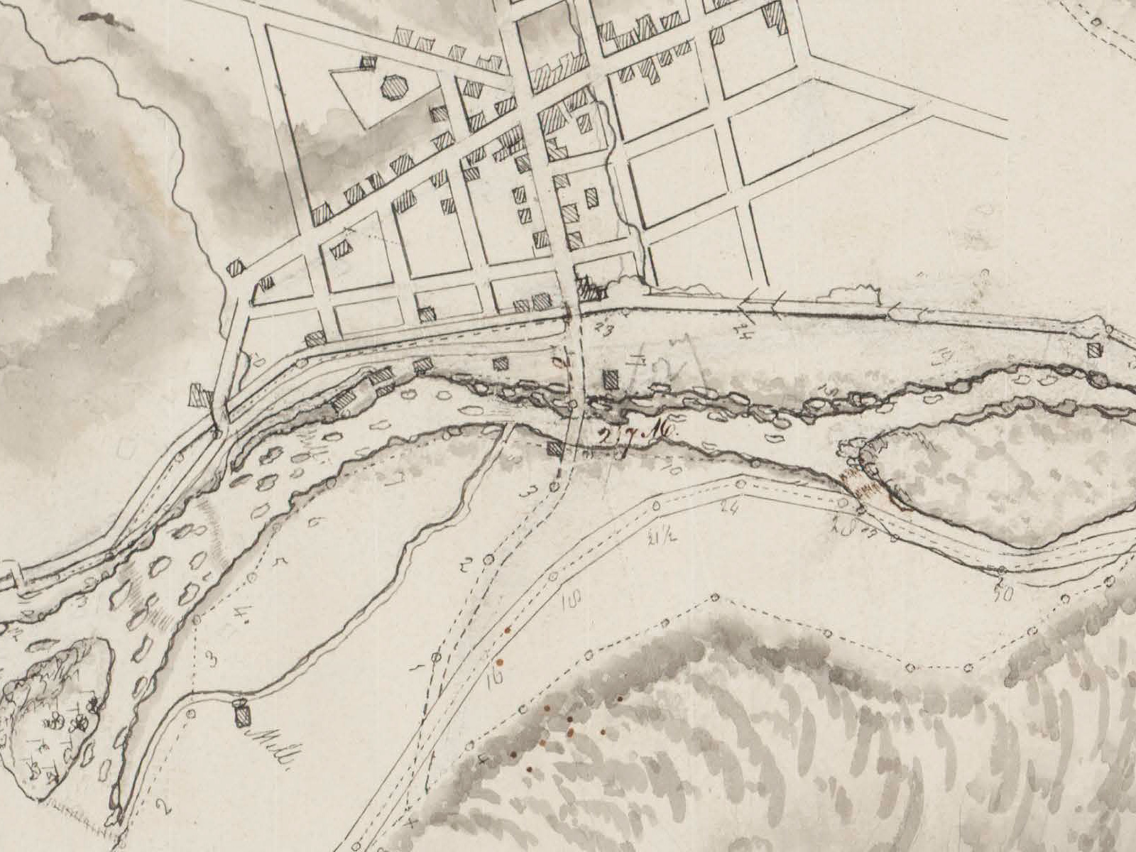
Erie Canal engineer Isaac Briggs sketched local landmarks, including a mill (lower left) and the Mohawk River bridge (center) when he surveyed the proposed route of the Erie Canal through Little Falls in 1818. (New York State Library)
“A good and substantial bridge”
One of the first bridges across the Mohawk — perhaps the first — was thrown over the river at Little Falls in the early 1790s. The builder was John Beardslee, a Connecticut Yankee characterized by Nathaniel Soley Benton in A History of Herkimer County as a “practical mechanic, architect, and civil engineer.”
But Beardslee’s daring design, a single wooden arch that leapt over the rapids, became unsafe after only a few years. It would need to be replaced with something sturdier.
A group of leading citizens, including postmaster William Alexander and mill owner Christopher P. Bellinger, petitioned the state legislature to allow them to form the Fall Hill Turnpike and Bridge Company. The resulting incorporation act, passed April 9, 1804, charged the new company with two responsibilities: to build a short toll road along the foot of Fall Hill on the south bank of the Mohawk River, and to construct a new bridge.
The legislation instructed the company’s directors “to make a good and substantial bridge; and that said bridge shall be at least eighteen feet wide, with good and sufficient railings on each side of said bridge.” In the event that the bridge was “carried away by flood, or otherwise destroyed” — a regular occurrence in those days — “it shall be the duty of the said president, directors and company to rebuild the same within two years thereafter.”
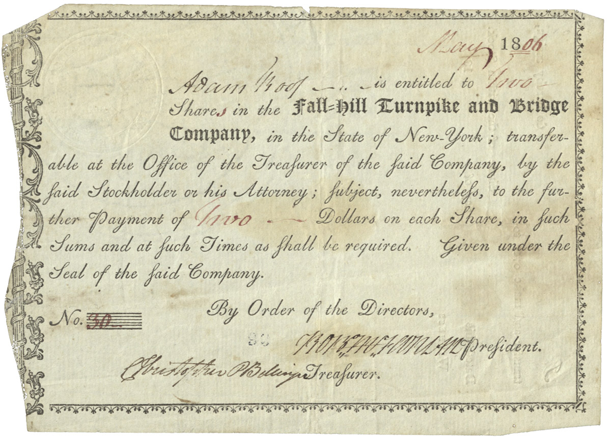
Certificate for two shares in the Fall Hill Turnpike and Bridge Company, made out to Adam Roof, dated May 1806 and signed by company president Robert McFarlan and treasurer Christopher P. Bellinger. (New York State Library)
The legislation went on to specify the rates of toll for the various kinds of traffic that might cross the bridge. Drovers would pay 8 cents for every score of sheep or hogs and 18 cents for every score of horses, cattle or mules. Carts drawn by one horse or mule would pay 6 cents. Rates were much higher for vehicles favored by the well-to-do: “every chariot, coach, coachee, or phaeton” would pay 25 cents.
Many users would be exempted from paying, including voters traveling to or from polling places, mourners attending funerals, patients visiting doctors, jurors, military troops, “any person going to or from any grist mill for the grinding of grain for his family use,” and so forth. In fact, the list of exceptions is so extensive that one wonders how the company was expected to make any money at all.
Tolls were also reduced for large wagons based on the width of their wheels. Those with wheels at least six inches wide would have their toll reduced by half; those with wheels at least nine inches wide, to one-fourth; and those with wheels at least twelve inches wide could pass “without paying any toll whatever.”
The Conestoga wagons used to haul freight on the turnpikes were enormous, 18 feet in length and 11 feet tall, and were drawn by teams of up to nine horses. One wagon could carry six tons of cargo. While the narrow wheels of smaller carts and carriages created ruts and damaged the track, the wide wheels of these heavy freight-carriers compacted and improved it. By reducing the fare for vehicles with wide wheels, the state and turnpike operators intended to improve the roadway as well as encourage trade.
Of course, any bridge built across the Mohawk would have to be sturdy enough to bear the weight of these huge, lumbering wagons. Good and substantial, indeed.
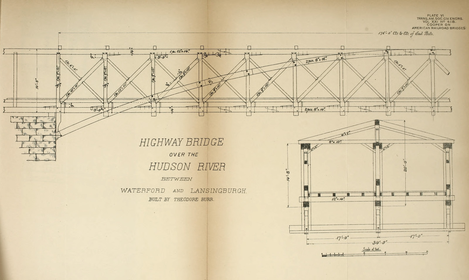
Theodore Burr’s arch-truss design, which he patented in 1806 and 1817, was used for his 1804 bridge over the Hudson River at Waterford. (“American Railroad Bridges” by Theodore Cooper, 1889. Snell Library, Northeastern University via Internet Archive)
The mysterious Mr. Burr
The builder of the new toll bridge may have been Theodore Burr, one of the most celebrated bridge builders of the early 19th century.
This is according to Jeptha Root Simms, author of Frontiersmen of New York, published in 1882. Simms was writing many years later, and his information appears to be anecdotal. Still, if he is correct, the connection to Burr would be significant.
Theodore Burr was yet another Connecticut Yankee. Unlike his more famous (and notorious) cousin Aaron, Theodore apparently eschewed politics and instead moved to Oxford, New York, in the 1790s to establish a career as a millwright. He built a home and began raising a family with his wife, Asenath Cook. Eventually they would have seven children.
Over the course of his career, Burr would design and build more than 40 bridges, including major structures across the Mohawk, Hudson, Delaware, and Susquehanna rivers. But much of his life, including the details of his untimely death, is shrouded in mystery.
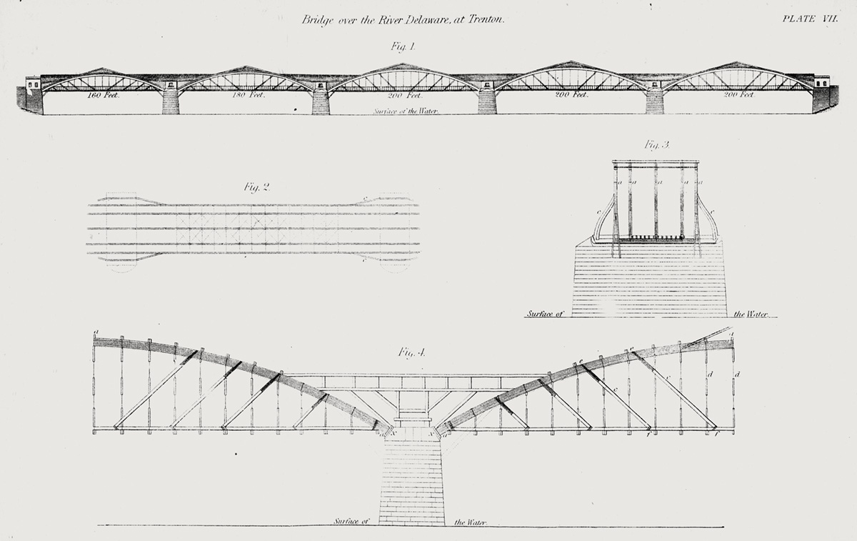
Diagrams of Theodore Burr’s bridge over the Delaware River at Trenton, New Jersey show the arrangement of the five wooden arches and the struts and braces that supported the roadway. (“American Railroad Bridges,” Theodore Cooper, 1889. Snell Library, Northeastern University via Internet Archive.)
He began by constructing a bridge across the Chenango River at Oxford, followed by a 400-foot-long bridge across Catskill Creek in 1802. His ambition grew with experience. By 1806 he had finished at least two more bridges: one across the Mohawk River at Canajoharie, and another across the Delaware at Trenton, New Jersey.
The Trenton bridge would be heralded in America and Europe as a masterpiece. Anchored on four masonry piers, its five wooden arches carried a double carriageway 1,008 feet across the Delaware River. The arches were protected by a roof of cedar shingles but their sides were exposed to reduce wind load, a decision that allowed passers-by to admire the intricate interplay of struts and braces. With some modifications, this bridge would remain in service until 1875.
The fate of the Canajoharie bridge would be different. It was constructed as a single 330-foot arch, at the time the longest in North America or Europe. In a 2004 article in Structure magazine, F. E. Griggs describes what followed: “In 1807 . . . the bridge began leaning after a herd of cattle bunched up on one side of it. Burr attempted to correct this lean with supports near the abutments, but the bridge failed shortly thereafter.” The collapse reportedly could be heard for miles.
The dynamics of truss and arch construction were imperfectly understood by early bridge builders. In 1808, French artist and traveler Henriette, Baroness Hyde de Neuville, painted this scene of the collapsed wooden arch bridge at Canajoharie. In the foreground she depicted herself, her husband, and pet spaniel, Volero. (Collection of the New-York Historical Society)
Burr’s later projects would include a 997-foot bridge over the Mohawk at Schenectady and a series of five bridges across the Susquehanna in Pennsylvania and Maryland.
His Schenectady bridge was a curiosity, a suspension bridge built of wood. In later years the elegant profile of the bridge’s wooden “cables” was obscured by an unsightly series of barn-shaped coverings. The roadway sagged and needed propping up with additional piers. Each spring, residents held their breath as they expected the flooding, ice-choked Mohawk to carry the bridge away. But it remained in service until 1873.
Unfortunately, Burr’s genius for design and experimentation was paired with a poorly developed business sense. He developed a habit of taking on too many projects at once. He was dogged by poor credit. Advance payments for one project were used to pay for others. He moved workers from nearly completed projects to those he deemed more pressing.
Soon after it was constructed, the details of Theodore Burr’s unusual Schenectady bridge were hidden from view by a series of barn-like covers added to protect the wooden structure from the elements. (Scribner’s Monthly, June 1876. University of Toronto via Internet Archive)
In 1822, the authors of a Pennsylvania legislative committee report complained that during construction of the Northumberland bridge “our bridge builder, Mr. Theodore Burr, having deserted the work, leaving our business to attend to contracts which he had subsequently made, we were under the necessity of finishing the work to save the bridge from perishing, by hiring hands ourselves.” They noted ruefully that “the managers never suspected that the man would have been so imprudent as to take on himself more work than he could attend to.” The company helped investors recover the extra cost by reclaiming $10,000 worth of company stock owned by Burr, which they had wisely retained as collateral.
Soon, none of this would matter to Theodore Burr. He had moved to Pennsylvania while working on his Susquehanna projects, and there, in November 1822, he died at the age of 51. The cause of his death was not recorded, nor was the location of his grave.
Today Burr is mostly remembered for his patented arch-truss, examples of which survive in historic covered bridges scattered across the northeast United States.
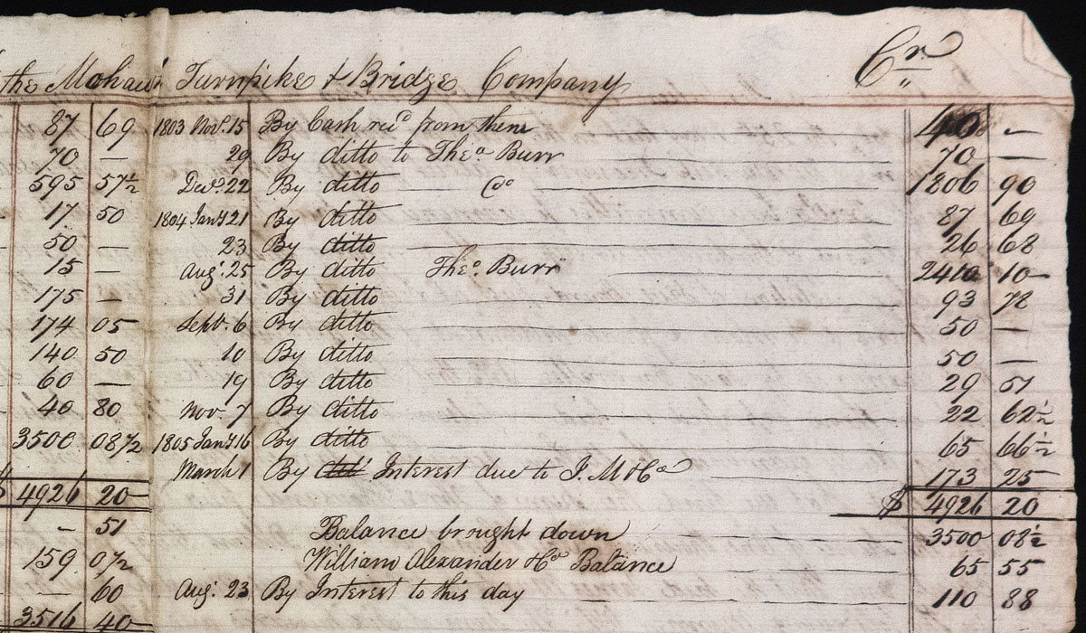
Several cash payments to “Theo. Burr,” from November 1803 to January 1805, are listed in a Mohawk Turnpike and Bridge Company balance sheet. (Buffalo History Museum)
Reconstructing the toll bridge
Did Burr build the Little Falls bridge? We can’t say for certain. No definitive source — a letter, contract, or ledger — has yet to surface. During the period of the bridge’s construction between 1804 and 1807, Burr was involved with several other much larger projects. But as we have seen, he often worked on many things at once.
We do have one small piece of indirect evidence.
William Alexander, the Little Falls postmaster, was on the boards of both the Fall Hill Turnpike and Bridge Company and the Mohawk Turnpike and Bridge Company, which had been organized in 1800. This was the company for which Burr would build the bridge at Schenectady. Another board member was James Murdoch, a Schenectady merchant and sometime business partner and correspondent of Alexander.
Tucked among Alexander’s surviving letters is a single-page balance sheet listing expenses to be reimbursed to Murdoch by the company. The expenses include several cash payments made by Murdoch to “Theo. Burr” from late 1803 to early 1805.
Clearly, Alexander — who at times served as president of the Fall Hill Turnpike and Bridge Company — knew about Burr. They may have been personally acquainted. Could this have been the connection that led to a commission to build the Little Falls bridge?
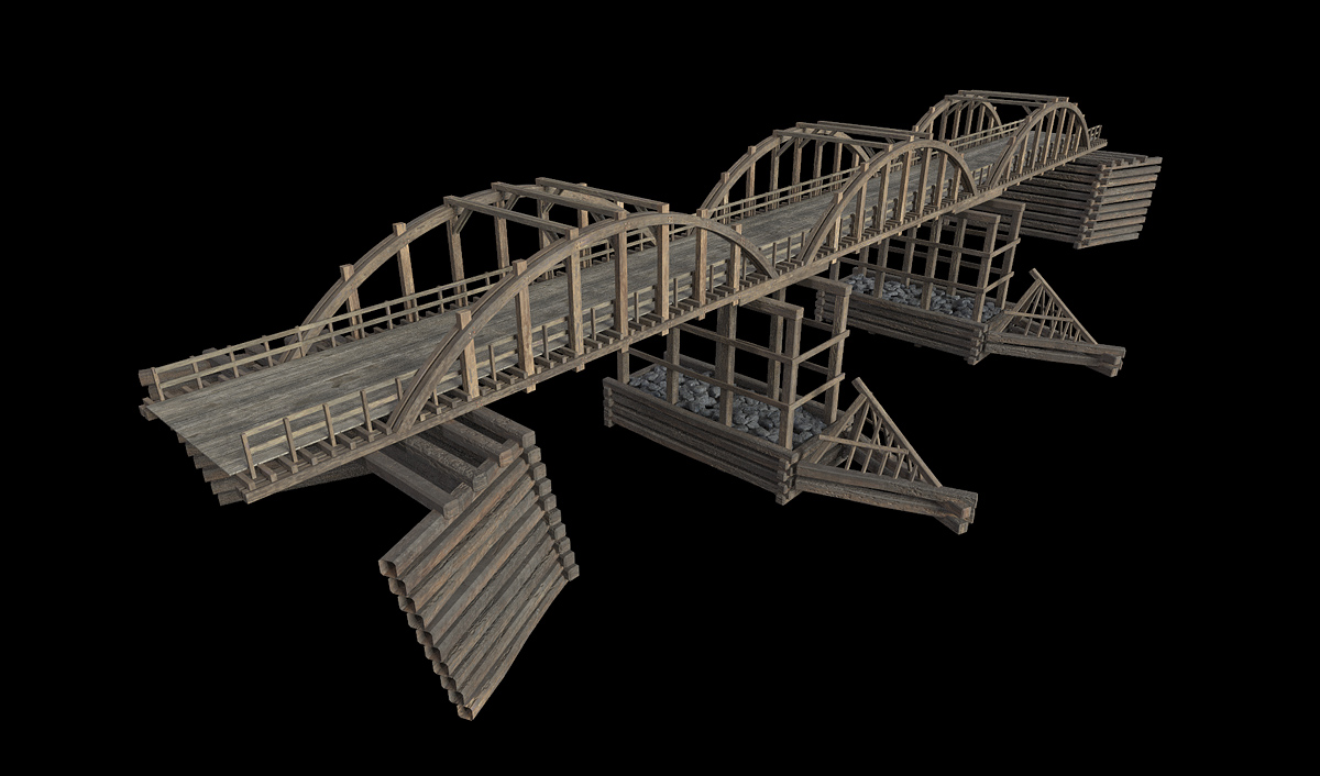
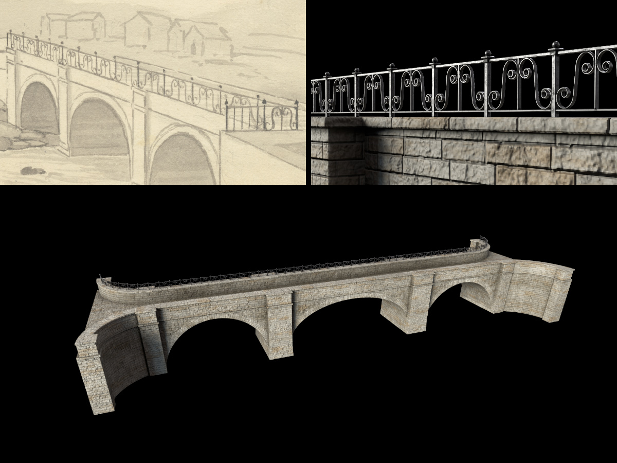
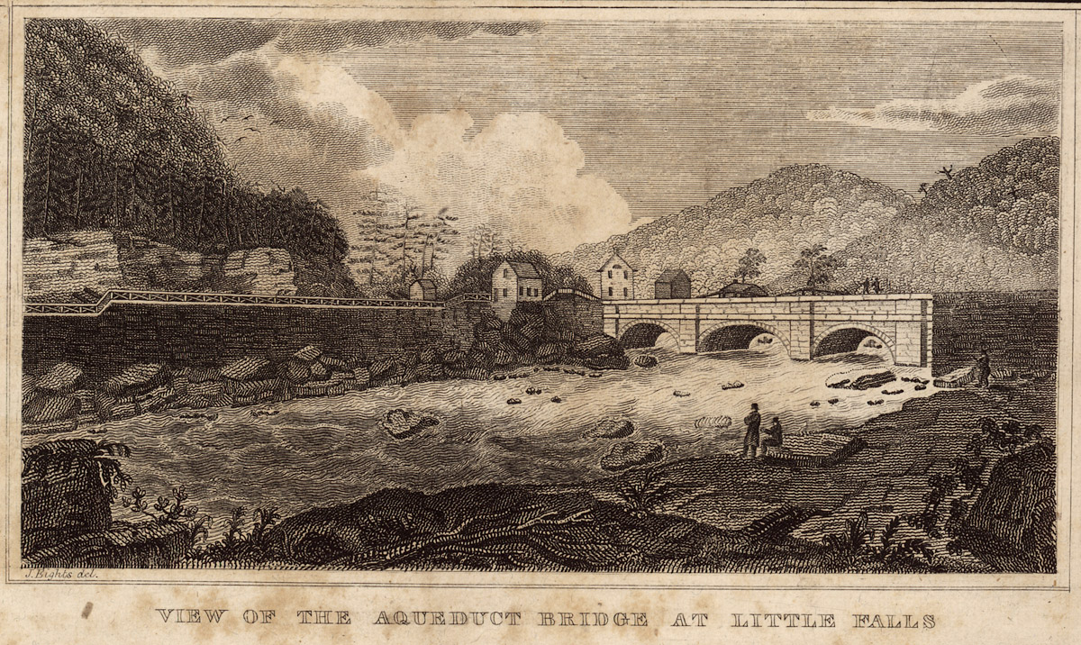
Even if we could prove that Burr built the bridge, that would not necessarily tell us what it looked like. Throughout his career he experimented with many different forms. The two pieces of visual evidence that we have — the 1829–1830 Holmes Hutchinson survey map and the 1824 James Eights engraving — indicate that it comprised three spans resting on two piers anchored on the rocky bed of the Mohawk River, and that each span was supported by an arch.
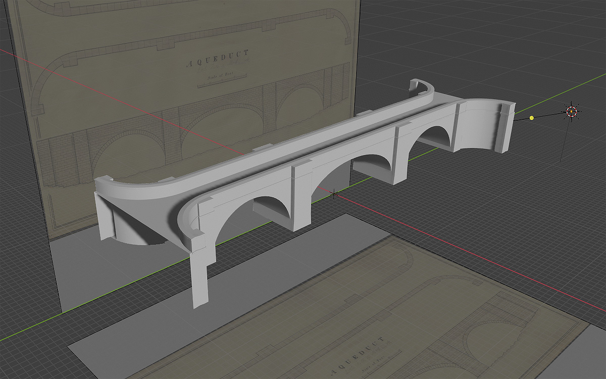
The model of the toll bridge at Little Falls spans the river with three 66-foot wooden arches. Wooden abutments and two piers, protected by icebreakers, support the 18-foot-wide roadway. The bridge features “good and sufficient railings,” as specified by the charter of incorporation. (Model and rendering by Steve Boerner)
The finished bridge model is based on these sources, as well as a few other contemporary engineering references. The 1838 edition of Dennis Hart Mahan’s An Elementary Course of Civil Engineering, for example, provides detailed instructions for building timber abutments and piers, and describes how those piers would be anchored in a shallow, swift-flowing river such as the Mohawk.
Much valuable information and advice was provided by Ronald Knapp and Terry Miller, whom I contacted via the Theodore Burr Covered Bridge Resource Center in Oxford, New York. They have done extensive research on Theodore Burr and his bridges, and I’d like to thank them for their insights on the bridge’s possible construction.
The bridge model will be added to the working scene, which is nearly finished. It will be placed directly behind the aqueduct and thus mostly hidden from the camera. About all that will be visible will be the top of the arches. A small detail, but one that provided yet another interesting detour on the way to Little Falls.
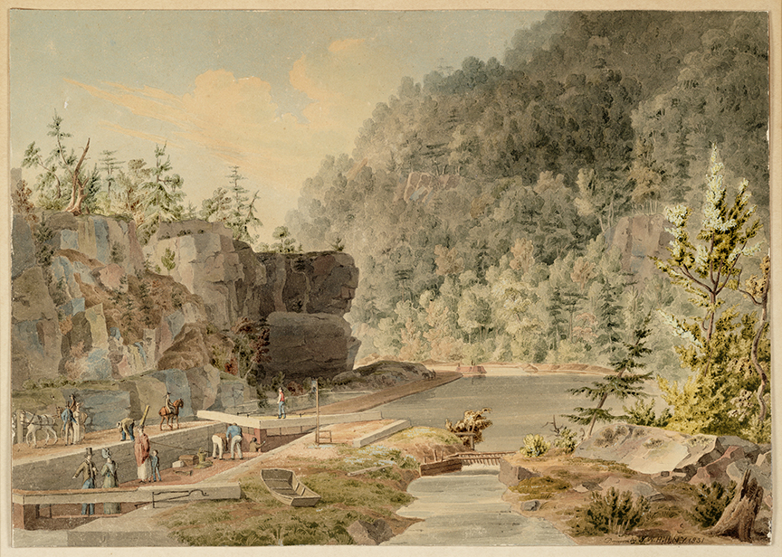
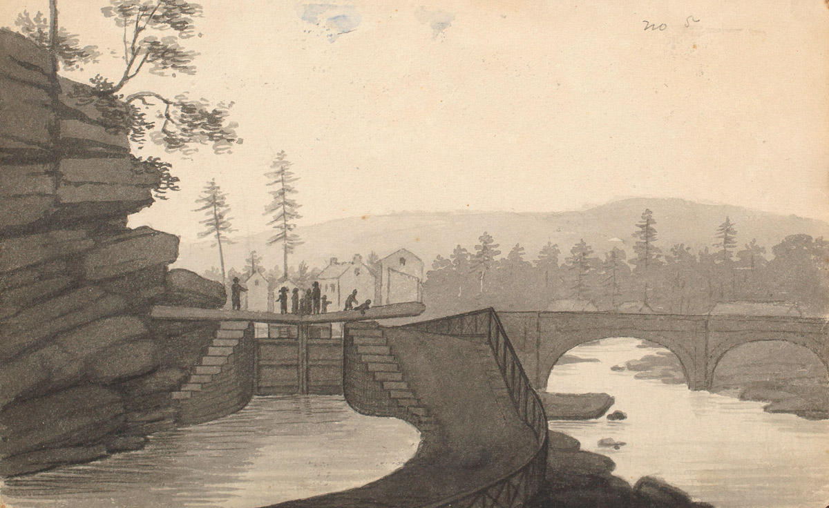
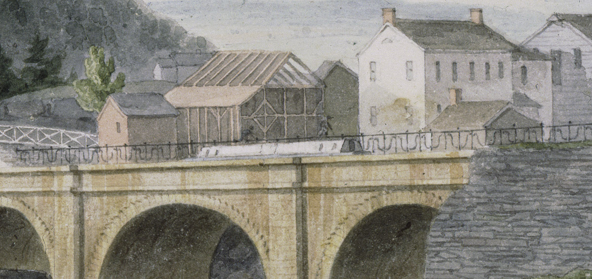
Watercolor by J. W. Hill looks east along the canal at Lock No. 43 in Little Falls. Profile Rock, a distinctive landmark for canal travelers, appears near the center of the frame. (Courtesy of the Union College Special Collection)
Little Falls was one of the most picturesque locations on the original Erie Canal, and its iconic aqueduct and dramatic Mohawk River gorge became favorite subjects for artists.
One of those artists was the young John William Hill, who had emigrated from England with his parents in 1819. Early on he worked in his father’s New York City shop, mastering the process of aquatint engraving. Between 1829 and 1831 he traveled across the state, painting watercolors to be used as studies for a portfolio of engravings of canal scenes. The portfolio was never published, but the surviving paintings — executed when he was about 20 years old — provide some of our most detailed views of the early canal.
Hill created his landscapes using the techniques of a miniaturist, building them with layer upon layer of tiny stipples. His precise brush captured details not found in other contemporary images.
Among other things, his watercolors depict packet boats and scows, the Little Falls aqueduct and, in the painting shown here, one of the five locks that lifted the canal around the rapids at Little Falls.
In the painting several passengers, including a woman with a small child, watch from the cabin roof of their packet boat while it is being locked. A tandem-rigged team of horses exits the left side of the frame on the towpath behind the boat, indicating that the packet is heading west. The boat is being lifted by the rising water level in the lock.
Near the bow of the packet, a male passenger appears to be describing the operation of the lock gates to his female companion. (Apparently, mansplaining was a thing even in 1831.) To the right is a rarely shown detail — the bypass flume, a ditch that diverted excess water around the lock. A rock-filled wooden crib near the flume’s outlet breaks the fall of the water as it reenters the canal.
In the background, the stony face of Profile Rock — a feature that survives to this day — mutely takes in the scene.
Several details from this painting, including the bypass flume and crib, are examples of the things that can be gleaned from contemporary paintings, sketches, and engravings. Along with other details, they will make their way into the Little Falls digital landscape.
The model of the aqueduct (bottom) is based on several sources, including this 1825 sketch by John Hopkins Sr. (upper left). The model’s bridge railing (upper right) matches his drawing. (Hopkins Family Papers, William L. Clements Library, The University of Michigan, upper left; Steve Boerner, renderings).
As mentioned before, the aqueduct at Little Falls was constructed in eight short weeks in late 1822 by contractor Ara Broadwell, who was paid $45,532.50 that year for this and various other projects near Little Falls. The wrought-iron railing was installed in 1824 at a cost of $1,552.60. The distinctive spiral design is documented in a sketch by John Hopkins Sr. and in J. W. Hill’s painting of the aqueduct, and appears in at least one photograph taken later in the century.
This large Greek-revival building appears in John Hopkins Jr.’s 1825 sketch (upper left), John W. Hill’s 1831 painting (lower left), and James Eights’ 1824 engraving (not shown). Also note the aqueduct railing detail in HIll’s painting. (Hopkins Family Papers, William L. Clements Library, The University of Michigan, upper left; The New York Public Library, lower left; Steve Boerner, right)
The village of Little Falls began to grow quickly after the canal opened. Comparisons of James Eights’ 1824 engraving, John Hopkins Jr.’s 1825 watercolor, and J. W. Hill’s 1831 watercolor show how quickly new buildings were going up on the south bank of the river. I’m planning to include a handful representing the buildings shown in Hopkins’ sketch. One building in particular seems to appear in all three images — a large, Greek Revival-style structure, possibly a public building like a tavern or hotel.
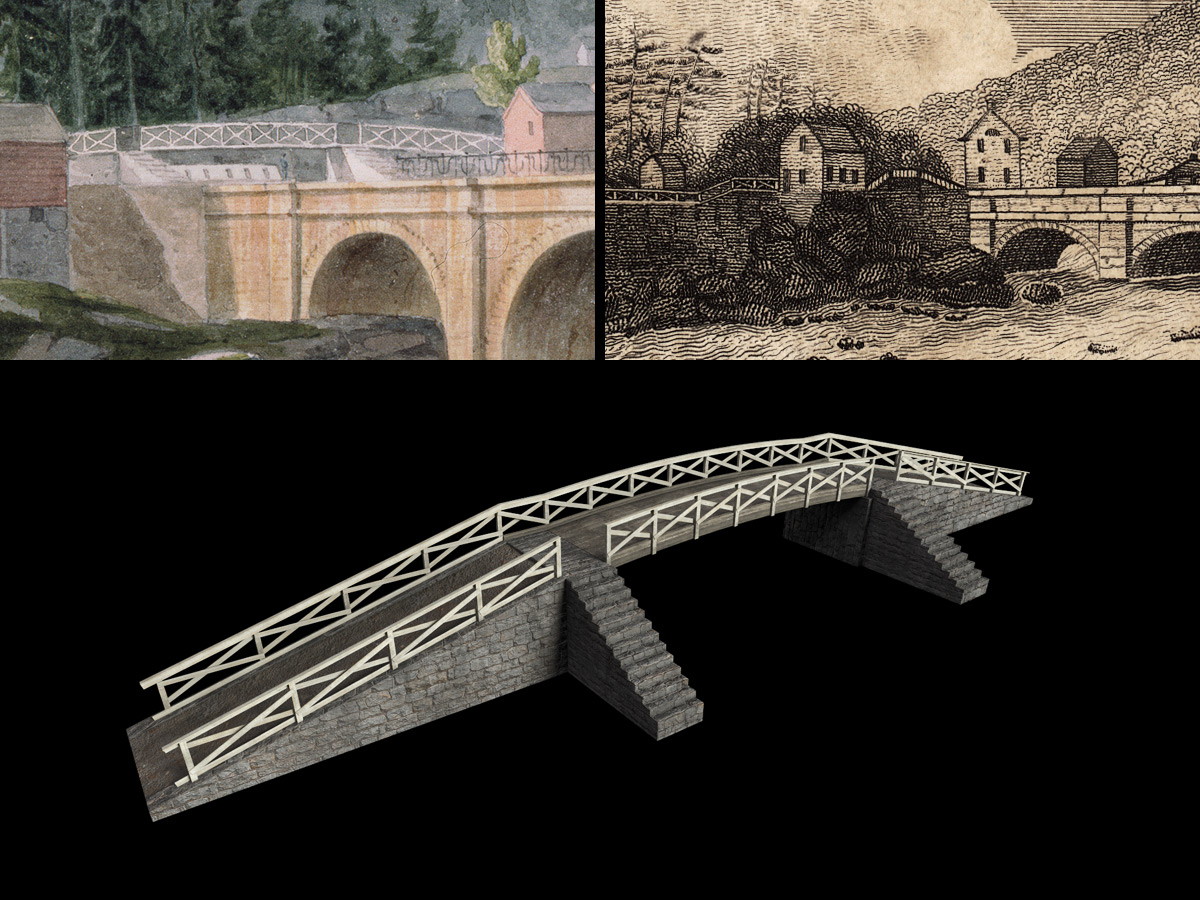
Model of the towpath bridge (bottom) is based on representations in J. W. Hill’s 1831 watercolor (upper left) and James Eights’ 1825 engraving. Also note the Greek Revival building just right of the bridge in Eights’ image. (The New York Public Library, upper left; Library of Congress, upper right; Steve Boerner, bottom)
The feeder channel carried across the Mohawk River by the aqueduct cuts across the towpath before it joins the Erie Canal. A bridge was needed, primarily for the animal teams that towed the boats, but also (judging from the stairs shown in J. W. Hill’s watercolor) for pedestrians. The bridge was constructed in 1822 by contractor John J. Walrath, who was paid $671.54 for building it along with two waste weirs. It won’t be a prominent feature in the digital scene, but it will nice to include it.
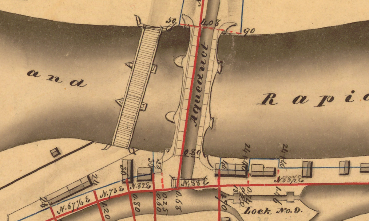
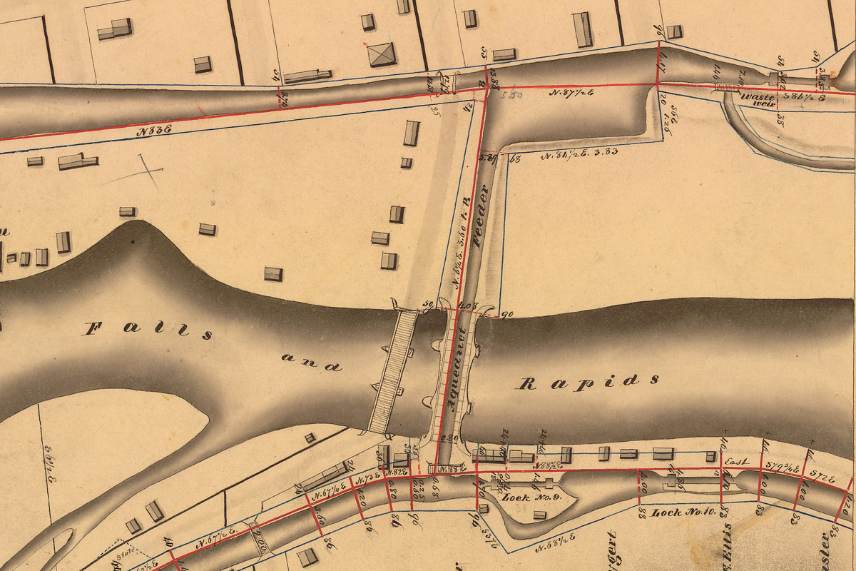
Detail of an 1830-31 survey map shows the Mohawk River road bridge next to the aqueduct, and the smaller, east-west towpath bridge directly south of the aqueduct. (New York State Archives)
Speaking of bridges, historical accounts dating back to at least 1792 mention a road bridge across the Mohawk River at Little Falls. The bridge — or a successor — is shown on the Holmes Hutchinson 1830–1831 survey map. It almost certainly was built of wood. But I haven’t been able to find a contemporary image that shows what it looked like.
The two wooden arches that appear behind the aqueduct in James Eights’ engraving may be the superstructure of the Little Falls road bridge. (Library of Congress)
James Eights’ 1824 engraving offers a tantalizing clue. If you look closely, you can see two wooden arches rising behind the aqueduct — right where the bridge would be. Perhaps these are part of the bridge’s superstructure.
Because of the camera angle, any model of the bridge would be obstructed by the aqueduct in the digital scene. (As it is in Eights’ engraving.) The plan for now is to omit it entirely. But we’ll see.
A rocky ledge extending from the base of Fall Hill, left, parallels the course of the Erie Canal and Mohawk River in this engraving by James Eight. This was one of several engravings that graced the margin of a geological profile of the canal published in 1824. (Library of Congress)
“What a tremendous, awe-inspiring scene! Nature has moulded her works, here, on a grand scale, — and soon we shall see, as we may even now, that Art has caught the inspiration of the scene, and well seconded her efforts, in giving to it a sublime effect, and a finish truly admirable.” — Horatio Gates Spafford, A Pocket Guide for the Tourist and Traveller, 1824
Horatio Spafford wasn’t the only traveler thrilled by the dramatic scenery at Little Falls. This stretch along the Mohawk River, barely a mile long, was the highlight of the trip along the Erie Canal for many packet passengers.
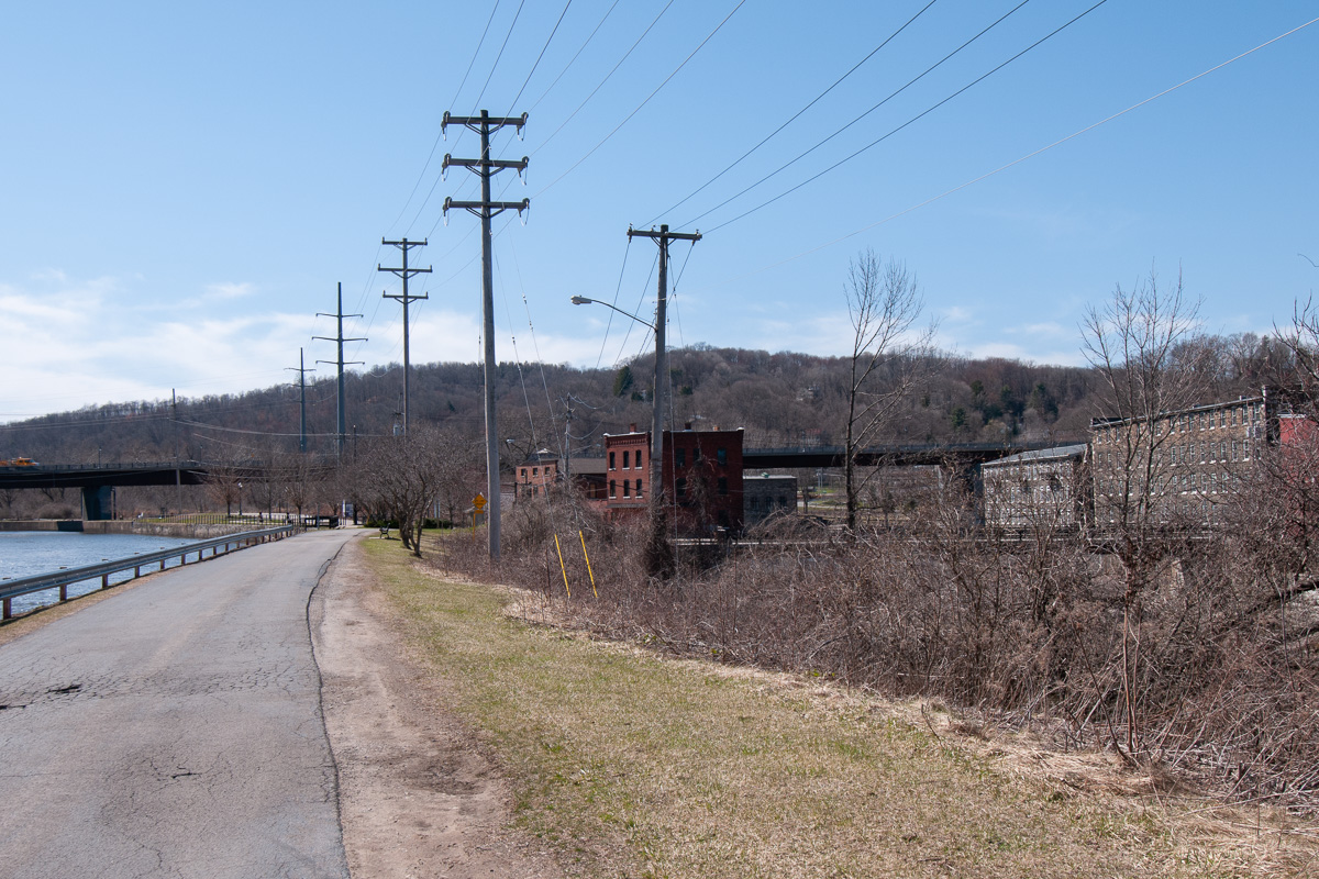
But things have changed a lot since then. The Mohawk has been walled in and its course altered by two hundred years of development. Hills and islands have been reshaped and removed to make way for railroads, highways, and a modernized canal.
This remarkable view of the Little Falls aqueduct, looking west with one of the adjacent Erie Canal locks in the foreground, was sketched in watercolor by John Henry Hopkins, an Episcopalian bishop who rode a packet boat along the canal less than two weeks after it opened in 1825. The rocky shelf depicted in James Eight’s engraving, above, appears here as a towering, blocky cliff. (Hopkins Family Papers, William L. Clements Library, The University of Michigan)
The cliffs that once lined the narrow gorge may be the most conspicuous casualties of all this progress. Those on the north side, including a famous landmark named Profile Rock, were half buried when the channel was raised for the New York State Barge Canal in the early 20th century. Those to the south were cut away, first to make room for the double locks of the Enlarged Erie in the mid-19th century, and later for the even wider channel of the Barge Canal.
The idyllic landscape sketched by John Henry Hopkins is long gone.
If John Henry Hopkins were to repeat his trip through Little Falls today, this is what he would see. This photo, taken from roughly the same location where he made his sketch in 1825, shows the channel of the modern Erie Canal at left. The Mohawk River gorge, right, is obscured by brush, and the historic center of Little Falls can be seen beyond. The only features that haven’t changed are the hills in the distance. (Steve Boerner)
To recreate the historical landscape, we’ll pretty much have to start from scratch.
The Mohawk River valley narrows dramatically as it cuts through the glaciated, hilly terrain at Little Falls. The 40-foot drop in elevation at the rapids represents a significant step along the river’s long descent to tidewater at the Hudson.
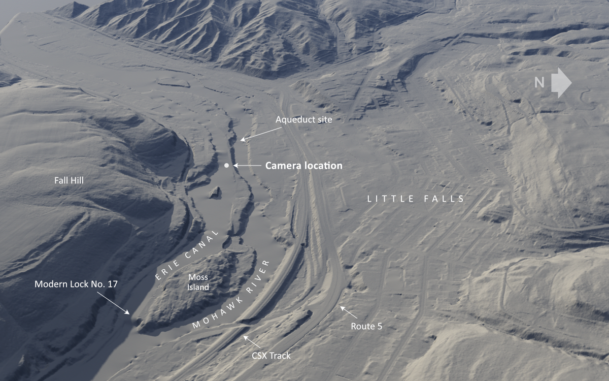
This rendering of digital elevation data available from New York state shows how the Mohawk Valley narrows at Little Falls. The modern Erie Canal bypasses the rapids, just like the original canal did in 1825, but rejoins the river below Moss Island. In 1825, five locks were required to lift the canal around the falls, but Lock No. 17, an unusual vertical-gate lock with a lift of 40.5 feet, eventually replaced all of them. (Digital elevation data from NYS GIS, rendering by Steve Boerner)
Digital elevation data, downloaded from the New York State Geographic Information Systems Clearinghouse and rendered in Terragen, shows how the valley has been extensively altered over the years. The camera position shown here will give us a view similar to the one sketched by Hopkins in 1825.
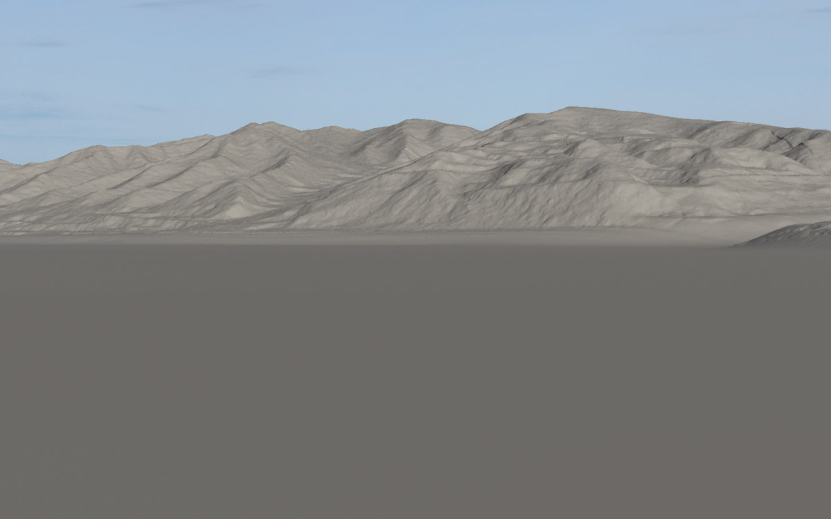
Here is the view from the camera after it is placed in the landscape. Nearly everything in the scene has been removed so we can begin to rebuild the historical terrain. Only the hills to the west are retained. (Steve Boerner)
As with previous scenes, we will use the modern elevation data as a starting point, and modify it to recreate the historical landscape. But this time few features can be retained. Only the hills to the west of our position have survived relatively unscathed. We will keep those and remove everything else, including the Mohawk River gorge. The resulting basic landscape is perfectly flat, a digital blank slate except for the distant hills.
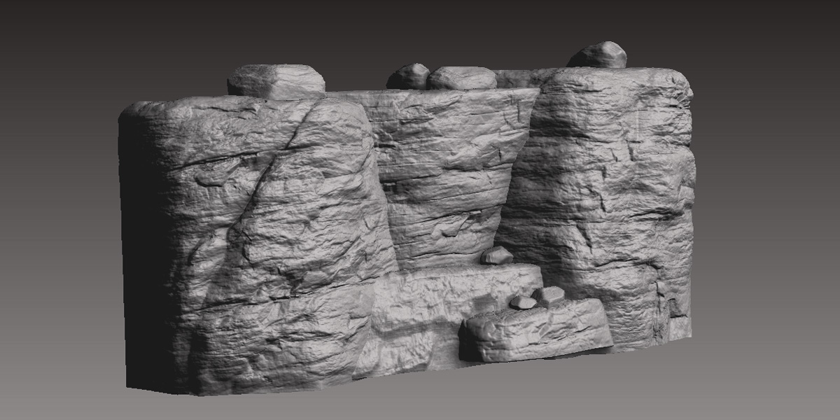
A section of the sculpted rock outcropping, shown in the ZBrush workspace. The structure is based on surviving cliff faces found nearby. (Steve Boerner)
The rocky ledge depicted by Hopkins and Eight has a very distinct structure. After attempting to model it in Terragen and other applications, I decided to create it in ZBrush, a 3D application that allows you to sculpt digital objects as if they were made of clay. The sculpting process is labor intensive, but fortunately we need need only a small section.
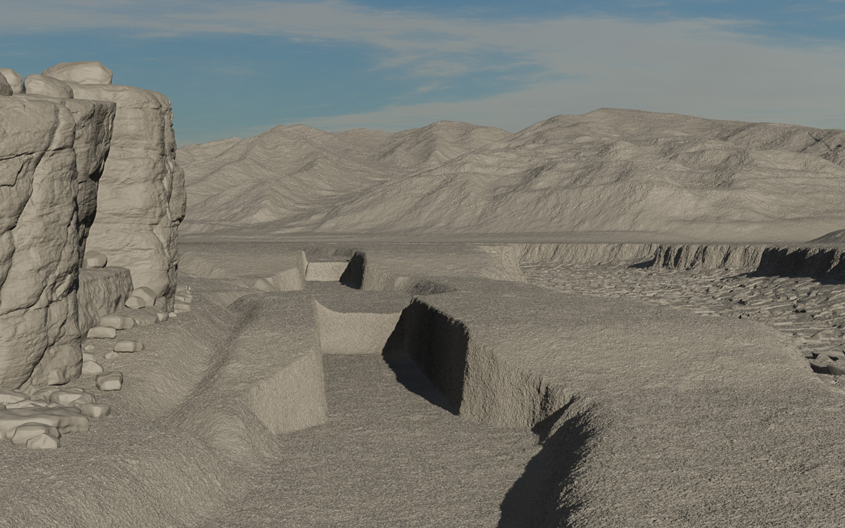
The landscape has been modeled to add the Mohawk River gorge (right), the rocky outcropping of Fall Hill (left), and the channel of the Erie Canal, with “excavated” sections for locks 43 and 44. (Steve Boerner)
The flattened digital landscape is then reshaped to add the rocky channel of the Mohawk River. The land surface is terraced and “excavated” to provide homes for the two locks. The sculpted cliff is placed in the scene, and channels for the bypass flumes, which diverted excess water around the locks, are added between the cliff and locks.
Hopkins, whose sketches are generally very accurate, for some reason ignored the bypass flumes. This allowed him to place the cliff near the canal, probably closer than it should have been. He also simplified the scene by omitting a second lock, which should appear in the distance. For the sake of historically accuracy, I’m including the flume and second lock.
The same view, with ground and rock textures, foliage, and water added. (Steve Boerner)
The landscape begins to look better with the addition of water, foliage, the aqueduct, and locks. There is much yet to be done: More structures, such as buildings and fences, need to be added. Plus boats, of course, along with crews and passengers, teams and drivers, and tenders to operate the locks.
An early American woodcut of a canal lock in action, from the title page of “History of the Rise, Progress, and Existing Condition of the Western Canals in the State of New-York,” by Elkanah Watson, 1820. (Library of Congress)
The early proponents of the Erie Canal were a remarkable group. Jesse Hawley, Elkanah Watson, and Gouverneur Morris showed great imagination — and risked being labeled as madmen — when in the early 19th century they individually proposed constructing an artificial river from the Hudson to the Great Lakes.
Hawley — a grain merchant with no advanced education — accurately predicted the canal’s route and final cost in a series of essays written while serving time in a Canandaigua jail for bankruptcy.
But these men were not engineers, and one detail they initially could not grasp was how, exactly, the canal would surmount the 568-foot difference in elevation between tidewater and Lake Erie. The general consensus was that the canal would be constructed as an inclined plane that gradually descended as it made its way, west to east, across the state.
The heavily glaciated terrain of New York state presented a serious obstacle to this plan. The canal would have to cross several rivers and valleys, including the wide, flat bowl of Cayuga Marsh. Enormous embankments would be needed to maintain a consistent slope across all of these elevations, and the mere thought of constructing these eventually made it clear that the whole idea was, well, crazy.
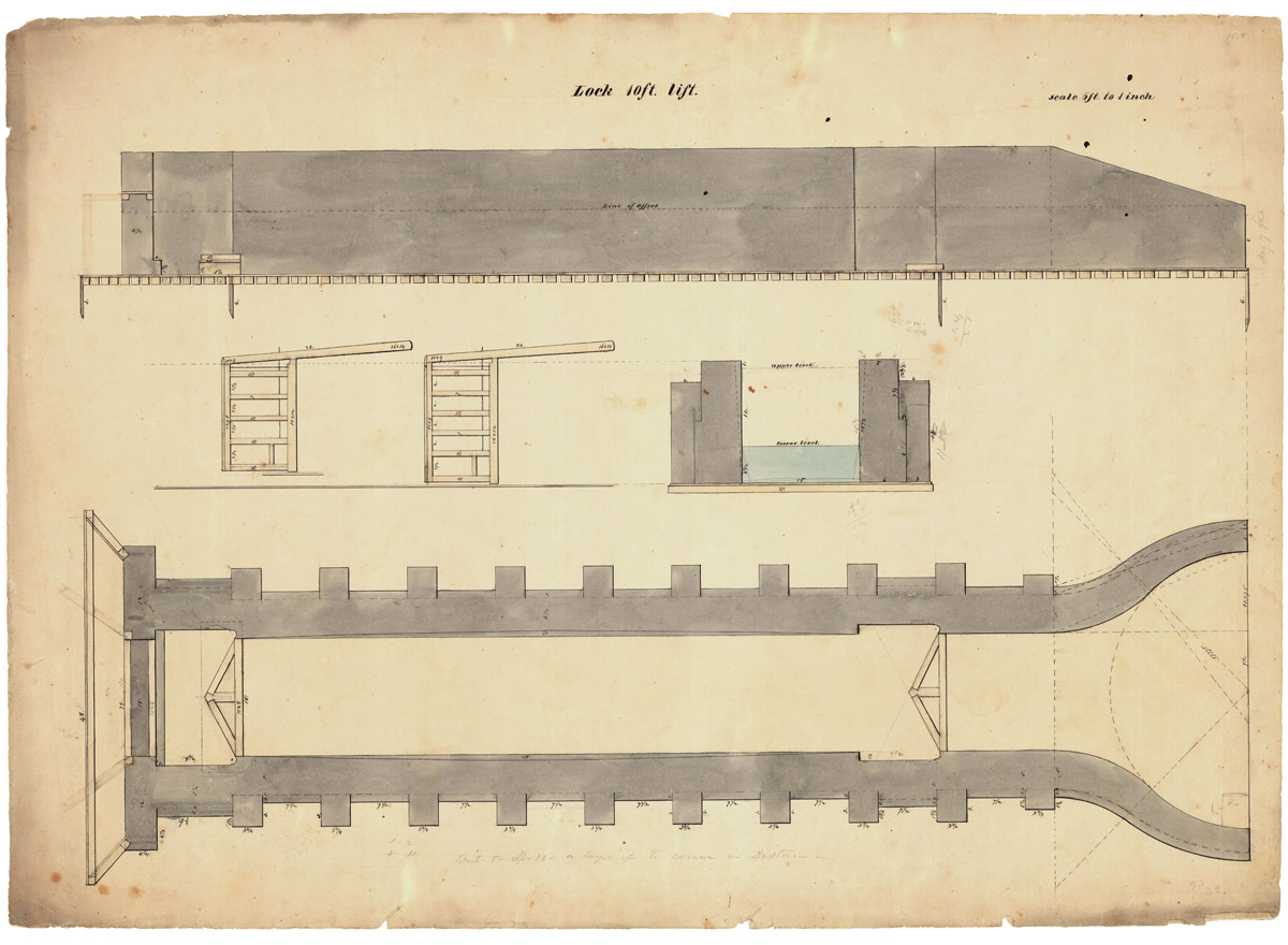
An undated scale drawing of a lock with a 10-foot lift. The triangular frames on the floor of the lock chamber are the miter sills, against which the lock gates were closed. The overall dimensions of the chamber match those of the locks on the first Erie Canal, though most of those had a lift of 8 feet. (John B. Jervis Drawings, Jervis Public Library, New York Heritage Digital Collections)
A more practical solution was the miter gate lock, invented in the late 15th century by Leonardo da Vinci.
A canal lock is basically a long chamber, large enough to accommodate a ship, boat, or barge, with a watertight gate on each end. After a vessel enters the chamber the gate behind it is closed and the water level inside is raised or lowered as needed. Then the other gate is opened to allow the vessel to continue on the new level.
The principle of the canal lock had been known for some time, and various types of gates had been used with varying degrees of success. Da Vinci’s innovation was simple but brilliant. The inside frames of his lock gates were mitered so that, when closed, the gates formed a V with the point facing the upper water level. The pressure of the water against the V forced the gates together, ensuring a tight seal.
Da Vinci’s design subsequently was used throughout Europe and for canals in the United States, including the Erie Canal. It is still used on canals today.
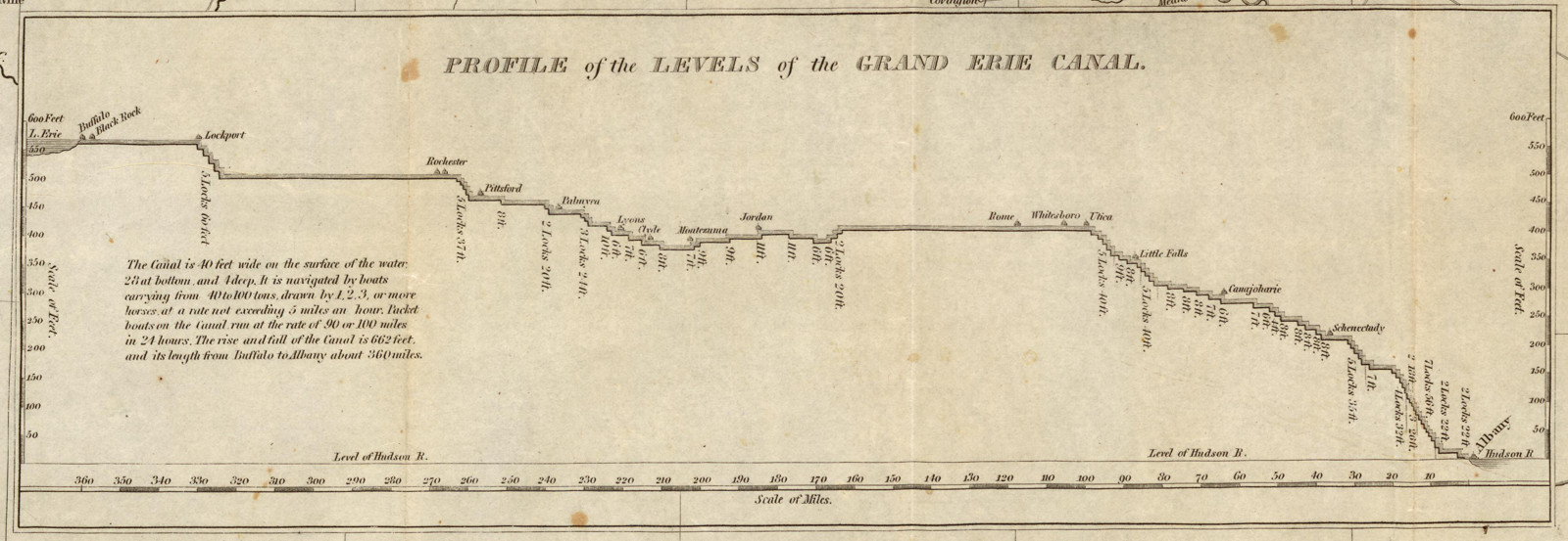
A profile of the Erie Canal, published in the margin of an 1827 map of New York state, shows how the canal climbed, lock by lock, from the Hudson River to Lake Erie. (David Rumsey Map Collection)
By the time work began on the Erie Canal, American engineers had already mastered the basics of lock construction, by trial and error, on earlier projects such as the Middlesex Canal in Massachusetts and the canals of the Western Inland Lock Navigation Company. Both wood and stone had been used as building materials. Over the years the many problems encountered with wooden locks convinced the Erie engineers that all of their locks should be built of stone, despite the higher initial cost.
In all, 83 locks with an average lift of eight feet would be built to lift the canal from tidewater at Albany to Lake Erie at Buffalo. The difference in elevation was 568 feet. But the descent at Cayuga, and a smaller one near Syracuse, increased the total rise and fall to 692 feet.
Lock 62 in Montezuma is one of very few surviving locks from the original Erie Canal. This was a guard lock that lowered boats to the level of the Seneca River so they could cross to the other side. Most of the chamber has been filled in with earth, but remains of the stone wall are visible. The dark, notched stone near the center indicates the location of a quoin pier that supported one of the lower gates. (Steve Boerner)
The standard lock chamber size on the first Erie Canal was 15 by 90 feet, which could accommodate vessels 78½ feet long by 14½ feet wide. Most locks had a vertical lift of eight feet (or less), though some had lifts of 9 or 10 feet and, in the case of the famous flight at Lockport, 12 feet.
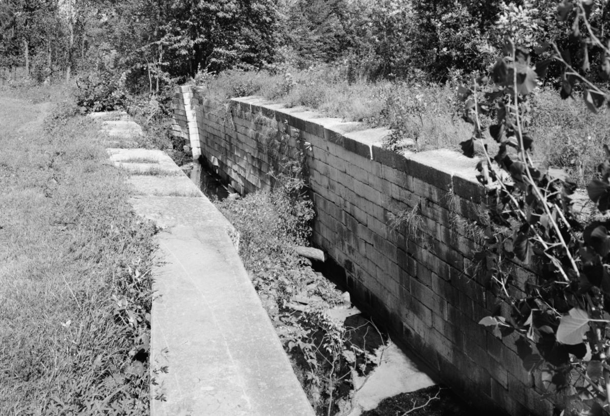
Original Erie Canal Lock No. 34, near Fort Hunter, Montgomery County, as it appeared in 1969. The lock is intact, but has since been filled in with earth to prevent the walls from collapsing. (Jack E. Boucher, Historic American Engineering Record, Library of Congress)
In a few locations, such as Lockport, the lock chambers were excavated out of solid rock. In others they were anchored directly on underlying bedrock. But in most places the bedrock was too deep and out of reach. There, hundreds of piles would be driven. On top of those a timber raft or mat would be laid and reinforced with planking. On top of this the stonemasons would construct the walls of the lock chamber.
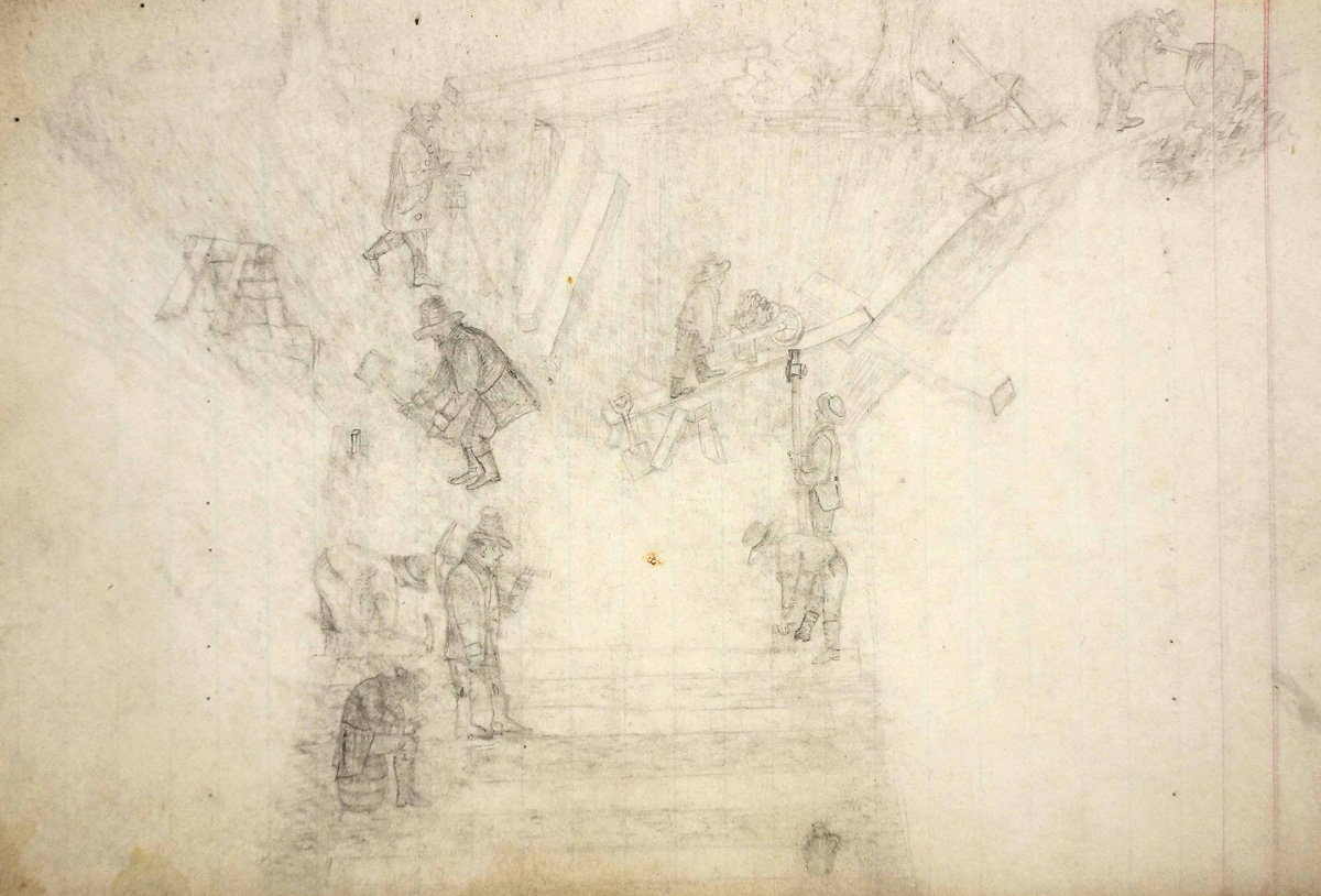
A lock pit for the Enlarged Erie Canal is a hub of activity in this 1855 field-book sketch by canal engineer Samuel Fenn. A surveyor, upper left, and rodman, center right, check levels while workers haul dirt and rubble up a makeshift wheelbarrow ramp to the top edge of the excavation. Three men on the floor of the pit place the timbers that will support the stonework. The ubiquitous whiskey jug is strategically positioned at the lower right. The sitting figure at lower left may represent Fenn himself, busily taking notes or, perhaps, penciling this sketch. (Series B0730, New York State Archives)
The process of building a lock was outlined in an 1826 proposal submitted by contractor David Fitzgerald to the canal commission:
“I propose to construct the Lock which is required on the Eastern section of the Erie Canal near Waggoner[’]s for the consideration of nine hundred dollars a foot lift, of the finding all materials . . . to the excavating the pit, piling and preparing a solid foundation, quarrying cutting and laying the masonry and completing the wood and Iron work and embanking puddling [and securing] the Lock. . . . The Lock to be fully completed in the month of September. . . . Lock 8 foot lift”
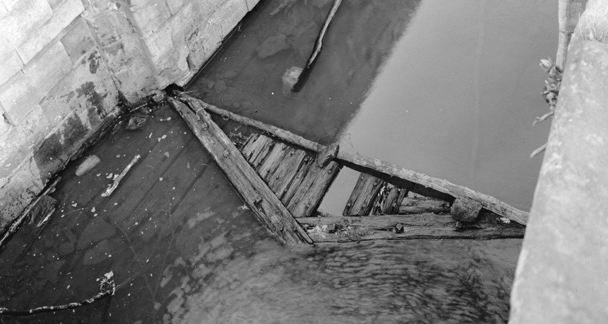
The wooden miter sill and floor planking of Chesapeake & Ohio Lock No. 55 in Maryland can be seen in this photo, taken in 1959–60. The lock gates are missing, but a recess in the lock wall for one of the gates, including the rounded pier for the gate’s quoin post, is visible at left. When the gate was closed, water pressure would have pressed it tightly against the quoin pier and miter sill, ensuring a tight seal. Locks for the first Erie Canal were also built this way. (Jack E. Boucher, Historic American Buildings Survey, Library of Congress)
Lock chamber walls were constructed of dressed stone, often quarried locally. For mortar, the masons initially used quicklime but soon adopted a new, much superior hydraulic cement developed by canal engineer Canvass White.
The stonemasons were craftsmen and they built things to last. But time and subsequent development have taken their toll. The remains of several 19th-century Erie Canal locks survive across New York state, but nearly all date from the First Enlargement, 1834–1862, or later. Surviving locks from the original canal are rare, so we have few direct references that can be used to help us create an accurate digital model of an original Erie Canal lock.
Fortunately, there are good, surviving examples of locks from other canals of the same period and a few contemporary drawings that we can turn to.
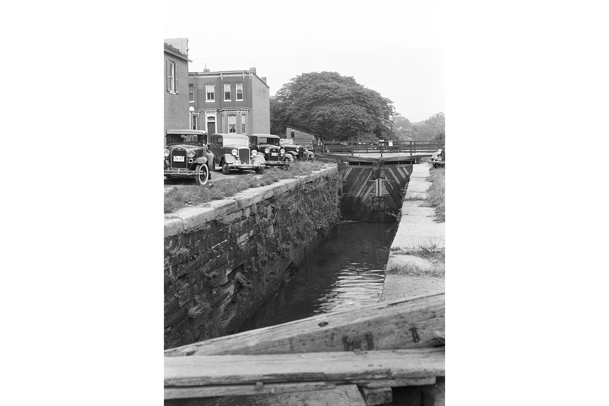
Vintage automobiles provide a sense of scale in this 1935 photo of Chesapeake & Ohio Lock No. 4 in Georgetown, Washington, D.C. C&O locks were built about the same time as those of the first Erie Canal, and to the same dimensions. (Albert S. Burns, Historic American Buildings Survey, Library of Congress)
Two other canals in particular can provide the information we need.
Construction of the Chesapeake & Ohio Canal began in 1828, a little over two years after the opening of the Erie Canal. It originally was planned to extend from Washington, D.C., to the Ohio River at Pittsburgh. But in 1850, after years of delays, labor unrest, and cost overruns, construction ground to a halt at Cumberland, Maryland.
Despite the fact that it was never truly completed, the C&O proved to be an efficient way to move coal from the Allegheny Mountains to the East Coast, and it remained in operation until 1924.
The C&O canal prism and locks were built to dimensions similar to those of the Erie Canal. But unlike the Erie Canal, the C&O was never enlarged. Many of its original structures remain in good condition and have been carefully documented by the National Park Service. Photographs, plans, and reports created by the service’s Historic American Buildings Survey (HABS) and Historic American Engineering Record (HAER) are kept at the Library of Congress, and most are available online.
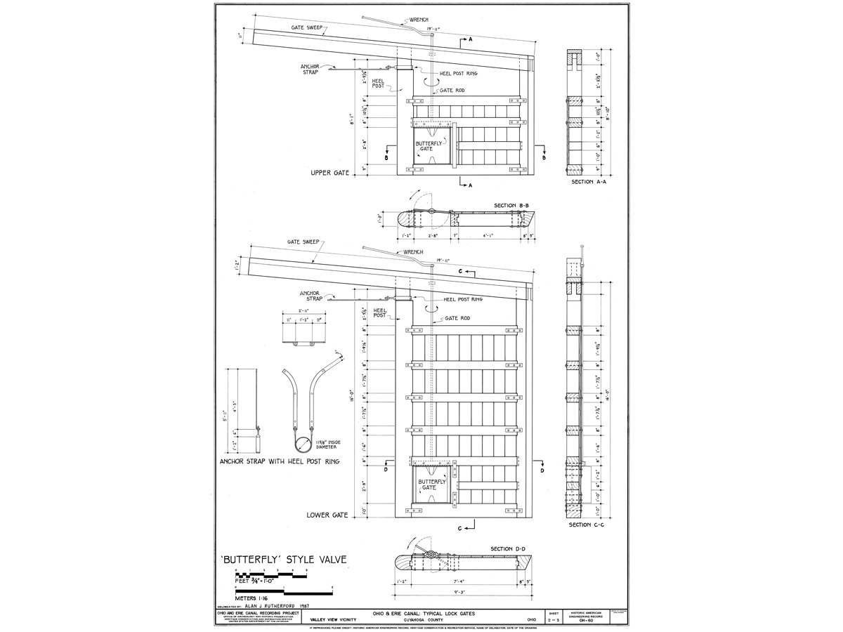
Drawings of early 19th-century lock gates used on the Ohio and Erie Canal, drafted in 1987 by Alan J. Rutherford of the U. S. Department of the Interior, show details such as the quoin post anchor irons, butterfly gate valves, and keys, which were the iron handles used to open and close the valves. Similar gates would have been used for locks on the first Erie Canal. (Alan J. Rutherford, Historic American Engineering Record, Library of Congress)
Much the same is true for the Ohio and Erie Canal, constructed from 1825 to 1832 to connect Lake Erie at Cleveland to the Ohio River at Portsmouth. Although most of the Ohio and Erie has not survived, sections of it have been preserved and documented by the park service.
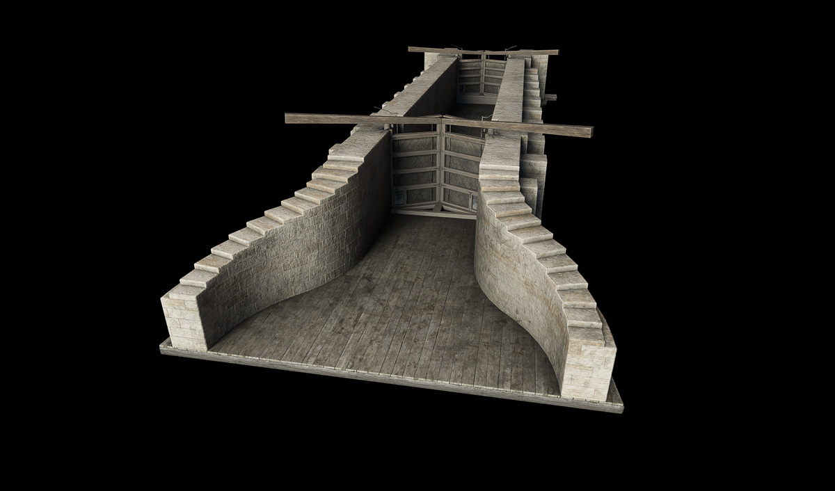
My digital lock model is based primarily on a plan and elevation drawing found among the papers of Erie Canal engineer John B. Jervis and preserved at the Jervis Public Library in Rome, New York. (Another drawing from this collection served as the basis of a digital model of the Little Falls Aqueduct.) The drawings show a lock of 10-foot lift, but it is easily adapted to fit the more usual 8-foot lift.
Model of a canal lock in the Blender workspace. The model is based on a lock diagram found among the papers of canal engineer John B. Jervis.
The model includes many details that will be hidden — below ground level or under water — when it is placed in a scene. These include the counterforts, buttresses that helped support the stone chamber walls; miter sills, which supported the lock gates when they were closed; and the gates’ butterfly valves, which were opened and closed by turning iron handles referred to as “keys.”
The finished canal lock model, shaded and rendered in Substance Painter.
Once the model is finished, surface detail and color are added in Substance Painter. Two copies of this model will be placed in the Little Falls scene to represent original Erie Canal locks 44 and 45.
This 1831 watercolor by John William Hill, “View on the Erie Canal,” may be our finest contemporary image of the handsome new aqueduct at Little Falls. The view looks south across the Mohawk River. Fall Hill dominates the skyline. A solitary boat crosses the aqueduct. Meanwhile an industrious party of men, wielding sledgehammers and crowbars, breaks up an exposed shelf of stone in the foreground. (The New York Public Library)
The village of Little Falls was once one of the most famous locations along the original Erie Canal. Early lithographs, engravings, and paintings show packet boats traversing the wild, romantic landscape as the canal skirts boulder-strewn rapids and rocky cliffs.
But today the original Erie depicted in the lithographs is long gone. The canal enlargement of the mid-19th century and construction of the New York State Barge Canal in the early 20th blasted or drowned many of the cliffs and rocky islands that had long distinguished this section of the Mohawk River.
It is hard to imagine how this place once looked, and easy to forget why it played such an important role in our early history.
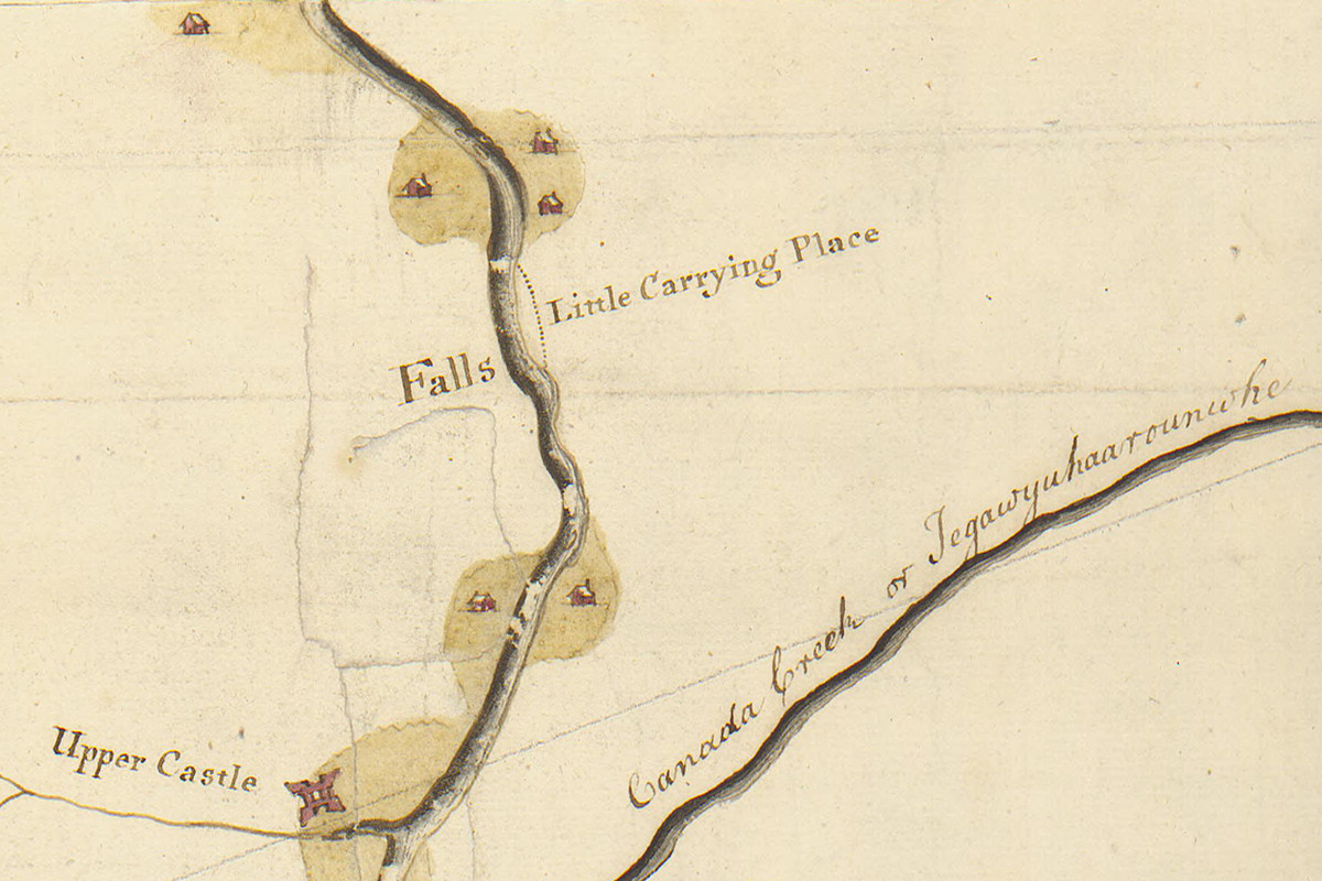
The portage around the Little Falls of the Mohawk River is indicated by a dotted line on a detail of a map drawn around 1756. North is to the right. (William L. Clements Library, The University of Michigan.)
The Little Carrying Place
The Little Falls were so named because they were the lesser of two major obstructions to navigation on the Mohawk River. Cohoes Falls, directly above Albany, was a more significant barrier. The Little Falls in turn were not even a waterfall so much as a bottleneck. This was a place where the valley narrowed dramatically and the river swirled around large boulders along a series of shallow rapids. The rapids extended three-quarters of a mile and dropped about 40 feet.
This was enough to force early navigators to beach their bateaus on the riverbank and drag them, along with their cargo, to the other end of the rapids. The section became known as the Little Carrying Place, and later, as the settlement of Little Falls took shape, businesses sprang up to provide room, board and other amenities to weary boatmen working their way up- and downriver. Eventually portage companies were formed which, for a fee, carted goods and boats on large wagons.
Building a bypass around the rapids became a top priority for the Western Inland Lock Navigation Company, chartered in 1792 to improve river navigation along the Mohawk. Construction of a short canal with five narrow locks soon commenced, employing “nearly three hundred laborers, besides a competent number of artificers,” according to a company report. Despite chronic financial problems, the difficulty of excavating through solid rock, and a lack of engineering experience on the part of the company’s officers, by November 1795 the canal around the Little Falls was completed “as to allow the passage of boats.” The village now had its own canal basin and waterfront.
A detail from the Holmes Hutchinson map of Little Falls, surveyed around 1830, shows the parallel channels of the Western Inland Lock Navigation Company canal (top), the Mohawk River, and the Erie Canal (bottom). The aqueduct allowed Erie Canal planners to use the old canal as a feeder and mollified the citizens of Little Falls by connecting their existing basin and waterfront to the new canal. (New York State Archives)
Unfortunately – from the point of view of local residents and merchants – twenty years later surveyors would locate the new Erie Canal on the opposite side of the Mohawk, threatening to leave Little Falls high and dry.
The solution was to build an aqueduct to connect the new canal on the south bank to the old one on the north, and like all good solutions it included something for everyone. Little Falls would be connected to the new canal, making its waterfront accessible to freighters and passenger packets. In turn, the old canal would become a water source — a feeder — for the new canal. And, incidentally, boats on the Mohawk could now come and go as they pleased between the river and the new canal.
‘This splendid work’
The new aqueduct would be one of many built along the Erie Canal. The Genesee River Aqueduct at Rochester would be the longest, at 802 feet. Others, built on the lower Mohawk, may have been more impressive feats of engineering. But none could match the aqueduct at Little Falls. The graceful, arched design, juxtaposed against the wild Mohawk River gorge, would be seen as vivid evidence of the victory of art over nature.
The aqueduct was constructed in 1822 by Ara Broadwell of Utica, a mason and contractor who had been building locks, culverts, and aqueducts along the canal since early 1818. The cost of the work, which took only about eight weeks to complete, is not itemized in the 1823 state comptroller’s report, but the report does specify $45,532.50 paid the previous year to Broadwell for stonework on the aqueduct and seven locks above the Falls.
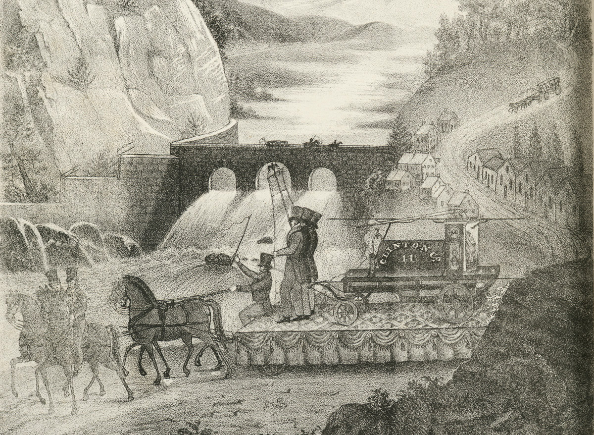
A lithograph published in Cadwallader Colden’s 1825 “Memoir” juxtaposed one of the floats in the celebratory New York City parade against a fanciful representation of the Mohawk River at Little Falls, with the new aqueduct dominating the natural landscape. (The New York Public Library)
The aqueduct’s opening was noted in the Oct. 22, 1822 edition of the Utica Gazette in an item widely reprinted in other New York state newspapers:
“The aqueduct across the Mohawk river at Little Falls was finished last week and filled with water. This is a structure of considerable magnitude, built entirely of stone, and in point of solidity and beauty, probably not exceeded by any work of the kind in the United States.”
In their 1823 report, the canal commissioners fill in a few important details:
“The aqueduct is a handsome structure of hewn lime stone, consisting of three arches, with abutments and piers resting on a foundation of solid rock; the centre arch of seventy feet chord spans the river; the other two are of fifty feet each . . . . The whole work supports two parapet walls, four feet broad, four and a half feet in height, and measuring two hundred and fourteen feet in length, and having a water way between them of sixteen feet.”
An 1825 watercolor by John Henry Hopkins shows a view of the aqueduct and its wrought-iron railing looking north to the village of Little Falls. (Hopkins Family Papers, William L. Clements Library, The University of Michigan)
The opening ceremony did not go quite as planned. A perhaps unintentionally droll account published a few days later in the Little Falls People’s Friend is worth quoting in full:
“Thursday, the 17th inst. having been named as the day when the first boat would pass over this splendid work, an immense concourse of people were assembled to view the operation. By about 3 o’clock P. M. our streets were rendered almost impassable by the crowd; the anxiety to see all that was going on was really surprising. At length the water was admitted from the old Canal and poured rapidly across to the new. All eyes were now directed to behold the first glimpse of the anticipated Packet-boat, and ‘expectation fairly stood on tip-toe.’ At this moment, a skiff entered from the Basin, and in this little barque, Capt. Robert Gillespie, of German Flatts, William, son of the late Wm. Alexander, and James Dowling, obtained the honor of being the first navigators of the Little Falls Aqueduct. But unfortunately, an accident soon after happened to the banks at the junction of the Aqueduct and the Erie canal; and it was found also, that the former, from the mortar’s not having had time to dry, emptied the water through the arches. These circumstances prevented the packet from passing that day, and greatly disappointed the spectators. But the deficiency will soon be supplied, and visitors may shortly be gratified with the wished for sight every day.”
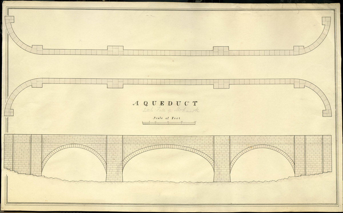
This undated drawing of an aqueduct is attributed to early American civil engineer John B. Jervis. Beneath the title in the center someone has penciled “Little Falls of Mohawk.” (John B. Jervis Drawings, Jervis Public Library, New York Heritage Digital Collections)
Recreating the aqueduct
The new aqueduct instantly became one of the iconic symbols of the new canal and a popular subject for contemporary artists. We have many good images that can be used as references. One of the finest, painted by John William Hill when he was 18 or 19 years old, is included at the top of this post.
Another good source is a set of watercolor sketches by John Henry Hopkins, an Episcopalian bishop who kept a journal of his travels in November 1825. While his entries regarding the Erie Canal are remarkably concise (“Wednesday, Nov. 9. Still on board the boat proceeding to Utica. Arrived as far as Montezuma by night fall.”), the sketches he created while passing the long hours on deck offer detailed views of the canal only days after it opened. (We will meet Hopkins again in later posts.)
But we will start with an unsigned, undated plan and elevation of an aqueduct found among the papers of John B. Jervis in Rome, New York.
A digital scale model of the aqueduct is constructed in Blender, based on John Jervis’ drawing. (Model by Steve Boerner)
John Jervis is a prime example of the self-made man. He began his career as an axman on an early Erie Canal survey party and, largely self-taught, quickly rose through the ranks of the canal’s surveying and engineering corps. In a career that eventually spanned nearly 50 years, he became America’s preeminent civil engineer — a designer of canals, railroads and, most famously, the Croton Aqueduct in New York City.
The title of the drawing is simply “Aqueduct,” and even though someone has pencilled in the words “Little Falls of Mohawk” underneath, it is possible that it represents a generic aqueduct design. In fact it closely resembles stone aqueducts found on the Chesapeake & Ohio Canal and elsewhere. But the dimensions vary only slightly from those provided by the canal commissioners, and the elevation drawing perfectly matches the east face of the aqueduct shown in Hill’s watercolor.
A detail from John William Hill’s painting also shows the wrought-iron railing on the west parapet of the aqueduct. The aqueduct did not have a towpath, which is why the boat is being poled across by two men. (The New York Public Library)
The Jervis drawing, Hopkins sketch, and Hill painting all indicate that the aqueduct did not have a towpath. This was a surprise at first. But the old canal that it was connected to was not a towpath canal, and the aqueduct’s primary purpose was to serve as a feeder. So this makes sense when you think about it.
These sources provide most of the information needed to start working on a digital model of the aqueduct, which will be the centerpiece of a new scene to be set at Little Falls in 1823.
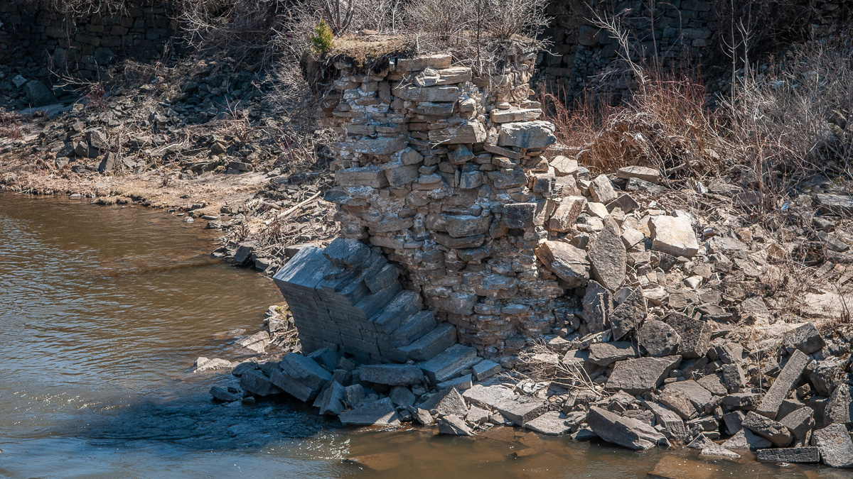
This pile of stones, part of the southern pier of the central arch, is all that remains today of the Little Falls Aqueduct. (Photo by Steve Boerner)
The passing years have not been kind to the Little Falls Aqueduct. Photographs show it in use — or at least watered — through the 19th century. But eventually the old Western Inland Lock Navigation Company canal was filled in to make way for development, depriving the aqueduct of its purpose. Maintenance stopped and, before the turn of the 20th century, it began to crumble. The central arch of this beautiful structure somehow defied the elements more or less intact until the 1990s, when most of it was washed away. Only a remnant, part of the southern pier of this arch, survives today.
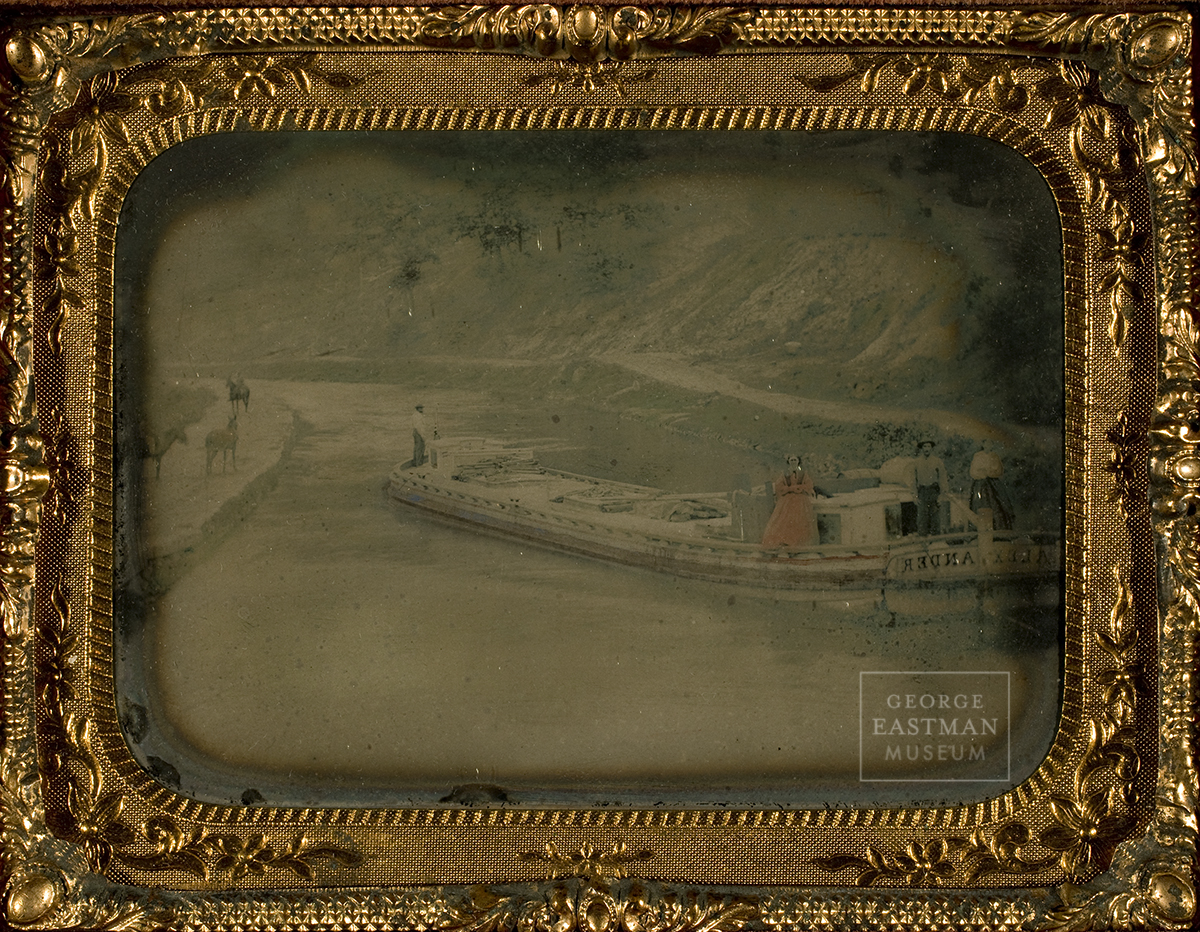
A classic Erie Canal freighter named the Alexander appears in this tintype, made around 1860. At left the mule team waits patiently on the towpath, while on the boat the owner, family, and crew pose, dressed in their Sunday best and looking for all the world as though they own the canal as well. The hand-tinted image is reversed because no negative was used in the tintype process; the metal plate itself was exposed to light in the camera. (Courtesy of the George Eastman Museum)
“Before me the stupendous prospect charms the eye. Forty feet from bank to bank the canal spreads. Its depth of four feet can support the mightiest bottom afloat. The hand-built towpath is three hundred and sixty-five miles long. As for the traffic, surely not all the argosies of Greece could equal this spectacle. There are lineboats, packet boats, ballheads, Durhams, gala boats, counter-sterns, toothpick scows, dugouts, arks, flats and periaugers, and always the slow rafts, all transporting such cargoes as were never before conceived of.”—Samuel Hopkins Adams, Canal Bride
From the very beginning, as soon as individual sections were finished and opened, the Erie Canal became jammed with all sorts of vessels. Many were barely seaworthy, rough rafts poled along by owners eager to cash in on the novelty and ease of this new mode of conveyance. Because the canal was built at taxpayer expense, it belonged to every citizen. Anyone who could pony up the toll could use it. And they did.
An open, square-ended scow hauling stone passes a fancy passenger packet in this detail from “View on the Erie Canal,” painted by John William Hill in 1829. (The New York Public Library)
As with many things concerning the early Erie Canal, details of the boats first used on it are now obscure. Mostly we are left with vague, second-hand accounts that don’t go into much detail.
These report that early freighters were small, 60 or 70 feet long, 7 feet in the beam, and could haul about 30 tons of cargo. By 1830 boats reached their maximum size, 75 feet long, about 14 feet in the beam, and could carry up to 75 tons.
The first set of dimensions are similar to those of a Durham boat, which suggests that some of those Mohawk River watercraft were being diverted to the canal to help fill a sudden demand for boats. Contemporary newspaper reports confirm this.
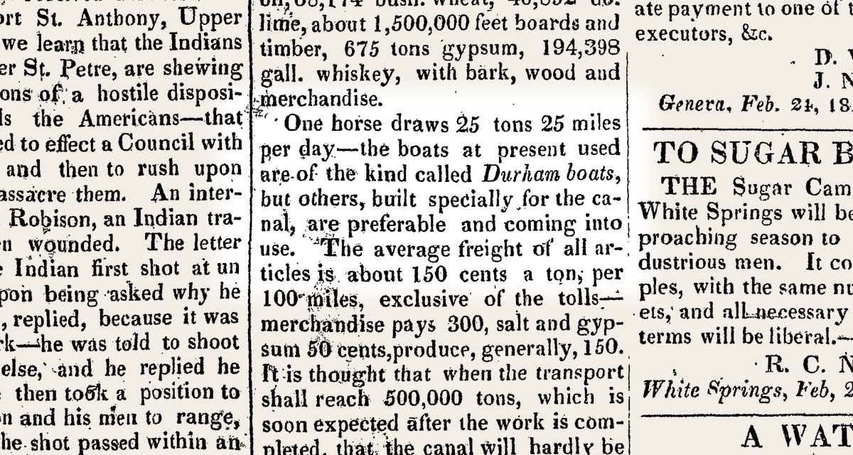
Boatbuilders began constructing vessels designed for the Erie Canal even before it was completely open. This item, reprinted from Niles Weekly Register in the Feb. 26, 1823 edition of the Geneva Palladium, describes how Durham boats were being replaced by those “built specially for the canal.” (New York Historic Newspapers)
At the time boatbuilding was a traditional occupation in which the master builders did not work from blueprints but from experience and memory. That sort of industry does not turn on a dime. It may be that existing boatyards continued to turn out boats modeled on the Durham long after the first sections of the canal were opened.
New boatyards eager to cash in soon sprang up, particularly in new canal boomtowns such as Utica, Rochester, and Buffalo. They would have built boats designed for maximum profit, as large as the canal’s 15-by-90-foot lock chambers would allow. I suspect that 14-by-75-foot boats would have been common well before 1830.
The canal commissioners allude to this in their 1825 report. “Two boats cannot pass each other upon any of the aqueducts,” they wrote, “and the canals being but 40 feet wide on the surface, and 28 at the bottom, and the boats 14 feet wide, only two can pass each other on the canal . . .”
Drawing by Tim Caza depicts the wreck of one of the canal boats discovered in 2019 on the floor of Seneca Lake. (Seneca Lake Archaeological & Bathymetric Survey)
Finger Lakes time capsule
Fortunately for us, working Erie Canal boats have been preserved at the bottom of a lake in central New York.
Seneca Lake, one of New York’s Finger Lakes, in 1828 was connected to the Erie Canal by the Cayuga and Seneca Canal. In 1834 a second lateral canal connected Watkins Glen, at the lake’s southern tip, to the Chemung River at Elmira. Canal boats, pulled by horse or mule teams along the laterals, were towed by steamships across the lake. The boats mostly carried Pennsylvania coal, but the Elmira, Corning, and Buffalo Line also advertised a weekly passenger run from Elmira to Buffalo.
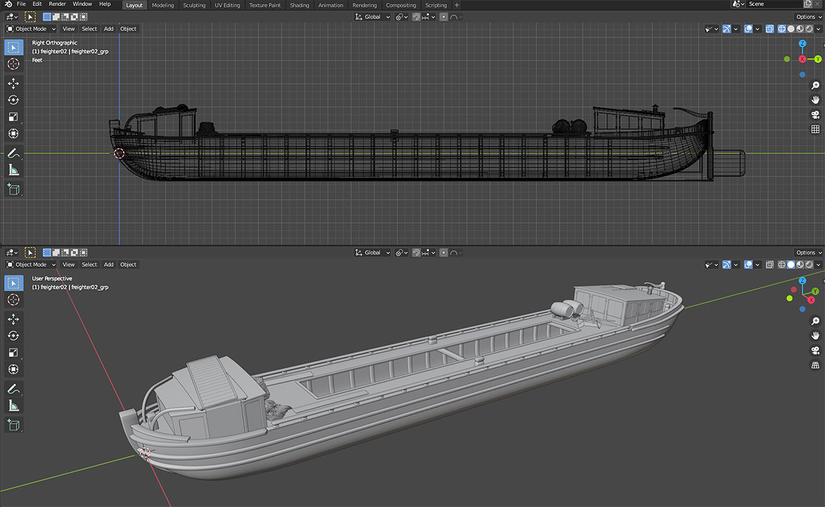
A model of an Erie Canal freighter based on the one discovered in Seneca Lake, in Blender. The graceful shape of the freighter’s hull becomes apparent in these orthogonal and perspective views. (Model by Steve Boerner)
Canal boats would be towed across the lake until 1878, when the Chemung Canal was abandoned. Not all of them made it. Seneca Lake, very deep and subject to sudden squalls, would claim a few.
An underwater survey using side-scan and multibeam sonar would begin to find them in 2018 and 2019. The Seneca Lake Archaeological & Bathymetric Survey was led by researchers from the Lake Champlain Maritime Museum with the support of New York state and several private organizations, and included members of the team that had discovered an early 19th-century Durham boat in Oneida Lake.
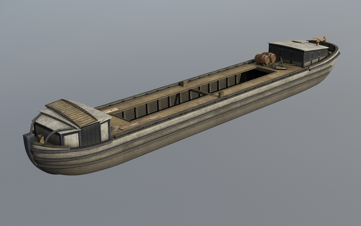
Freighter model, shaded and rendered in Terragen, includes a horse bridge stowed on top of the forward cabin, the “bow stable” where the boat’s off-duty team of horses or mules were sheltered. (Model by Steve Boerner)
Promising targets were visited and photographed by an underwater, remotely operated vehicle. The result is a catalog of 19th-century canal vessels, from scows and freighters to, incredibly, what looks to be a passenger packet. (You can support one of the survey sponsors, the Finger Lakes Boating Museum, by purchasing a printed copy of the survey report from their online shop.) Allowing for the fact that all of the wrecks are encrusted with invasive quagga mussels, many are in remarkable condition.
Several of the wrecks have been identified as original Erie Canal-era boats. In the late 19th century the average lifespan of a canal boat was 10 years. If this held true earlier in the century, then some of these boats, which date from the mid-1830s, may have been built in the 1820s.
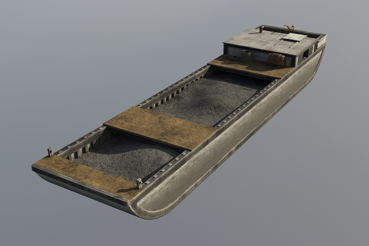
Model of an original Erie Cana-era scow, based on one of the wrecks discovered in Seneca Lake. (Model by Steve Boerner)
One of the wrecks was a scow, a open, square-ended design that was outlawed in the 1840s because of the damage its sharp corners caused to canal structures and other boats. But the hulls of the other original Erie-era wrecks have more graceful lines.
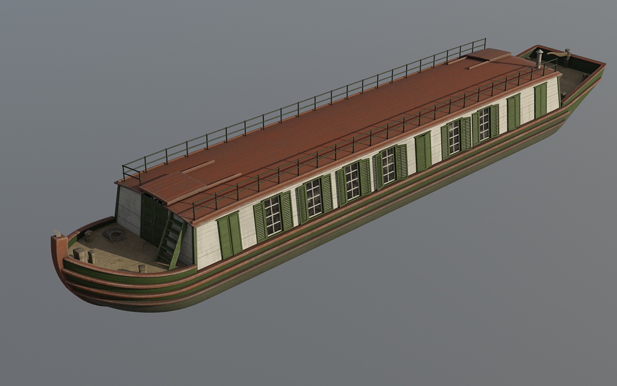
Model based on Target 7, a wreck that appears to be an original Erie Canal-era packet boat.
These shapes seem to differ from what would come later. The boxy lakers of the late 19th century and industrial steel barges of the 20th were, above all, utilitarian. But these were boats. It’s almost as if their builders, faced with the new challenge of crafting vessels for the placid waters of the Erie Canal, still had the unpredictable Mohawk River very much in mind.
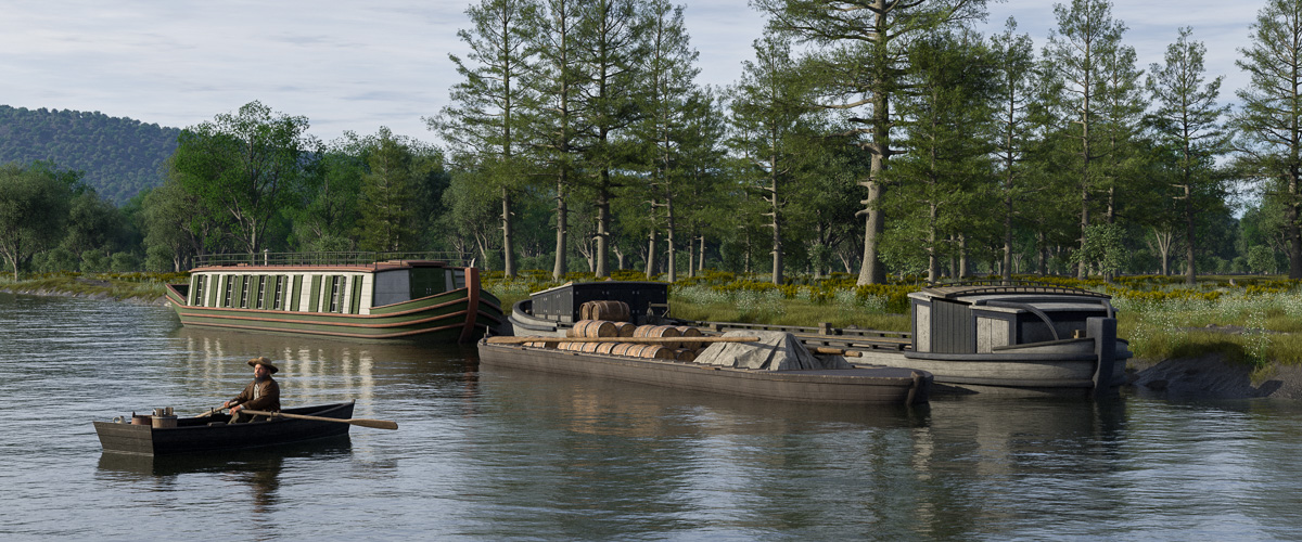
A scene put together to test some of the new boat models includes the packet (left), freighter (right, rear), and an existing model of a Mohawk River Durham boat (right, front) for comparison. (Rendering by Steve Boerner)
The expanded fleet of models will eventually find its way into new scenes as they are created. Next up will be adding some less-conventional vessels, like the log rafts (which were actually very common) used to transport timber to market, a line boat, and maybe even a periauger.
Without a doubt, the early canal years featured a more diverse and colorful array of watercraft than we can imagine today. For the wide-eyed Yorkers along the canal route, astounded by the sight of boats floating one after another through the landscape, it really must have been quite a spectacle.