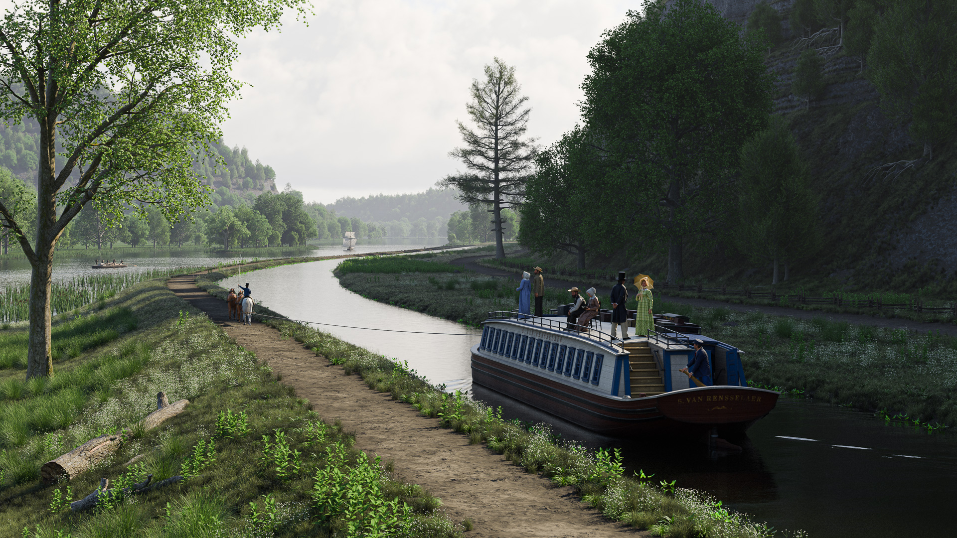
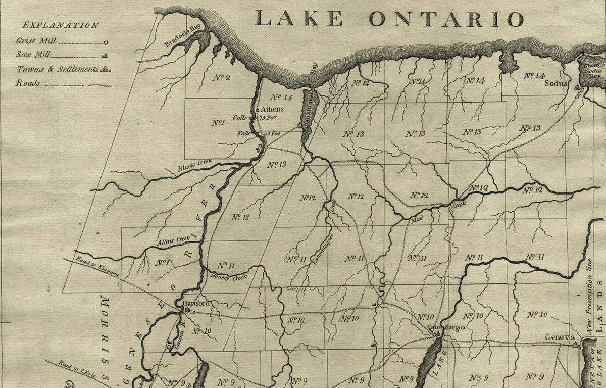
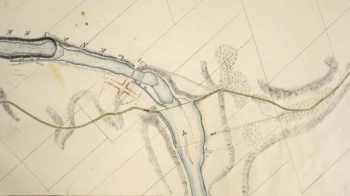
This 1866 map shows the low-water boundaries of the Genesee River in Rochester “as they probably were between 1820 & 1830.” It was included in a report published by a commission investigating the causes of the 1865 Rochester flood. (“Report of the Commissioners Appointed to Investigate the Causes of the Inundation of the City of Rochester in March, 1865,” Documents of the Assembly of the State of New York, 1866, vol. 5, issue 117)
The historical outlines of the Genesee River in Rochester might still be a mystery if it hadn’t been for the flood of 1865.
Seeking an explanation for the sudden inundation, the New York state legislature in 1866 appointed a panel of prominent Rochester citizens to investigate. The four men — Addison Gardner, former New York Court of Appeals judge and lieutenant governor; Amon Bronson, lumber dealer and supervisor of the city’s Third Ward; Levi A. Ward, a founder of the Rochester Gas Company and former mayor; and grain merchant George J. Whitney — took their task seriously and, assisted by Isaac F. Quinby, professor of mathematics at the recently established University of Rochester, undertook a detailed study of the brief but tempestuous relationship between the river and the rapidly expanding settlement on its banks.1
Among other things, they commissioned the first accurate surveys of the river, which documented the locations of the second aqueduct, bridges, and adjacent buildings, and the elevations of the riverbed from the Johnson mill dam to the brink of the High Falls.
But when it came time to establish the historic location of the river’s shoreline — something that should have been well within living memory — the commissioners were left scratching their heads. They wrote:
“In devising measures to prevent future inundations, it would be of much assistance to ascertain the boundaries of the river, which had been established by natural causes before the city was founded; but the land marks by which to fix these boundaries have been so completely obliterated in the gradual growth of the city that the oldest residents do not agree in regard to them, and it is impossible to make an accurate representation of the river as it was fifty years ago within the present limits of the city.”2
In spite of this, and presumably with Professor Quinby’s able assistance, they forged ahead and gave it the old college try. Their final report included a fold-out map showing the low-water boundaries of the river “as they probably were between 1820 and 1830.”
It was, they wrote, “perhaps as close an approximation as can be hoped for.”3
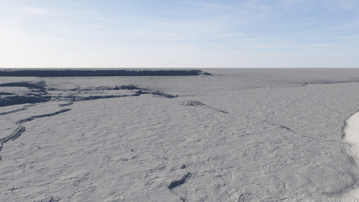
Elevation data published by the 1866 flood commission, along with its surveys and other maps of Rochester, made it possible to estimate the elevations of various terrain features as they would have existed in the early nineteenth century. This digitally sculpted surface is based on those estimates. The camera position is near the east bank of the Genesee River, looking west. The bed of the river dominates the bottom half of the frame, with the west bank and the rocky ledge visible in the distance. (Rendering by Steve Boerner.)
Reconstructing the river
The landscape I’m working on will show the original Rochester aqueduct under construction in the fall of 1822.
The Genesee River shaped the development of the village of Rochester, along with its mills, its bridges and, of course, the aqueduct. So, the first order of business was to build a three-dimensional map of the riverbed and terrain at the Upper Falls.
This is where the flood commissioners’ 1866 report enters the picture. Despite their misgivings, the commissioners did produce a fine map of the river’s historic low-water boundaries. It may have been a guess, but it was an educated one.
The other survey and elevation maps included in their report also contain a wealth of information. By comparing their measurements of the Genesee’s riverbed to the height of the first aqueduct, it becomes possible to estimate the historic elevations of the Genesee River, the millraces, and the rocky shelves on its east and west banks.
And this, in turn, can be used to sculpt a reasonably accurate three-dimensional terrain map.
The sculpted surface doesn’t look like much. Aside from the rocky ledge in the background and a few small shelves or “rifts” in the riverbed, there isn’t much variation here. But these slight elevation changes played an outsize role in the early development of Rochester, so it was important to get them right.
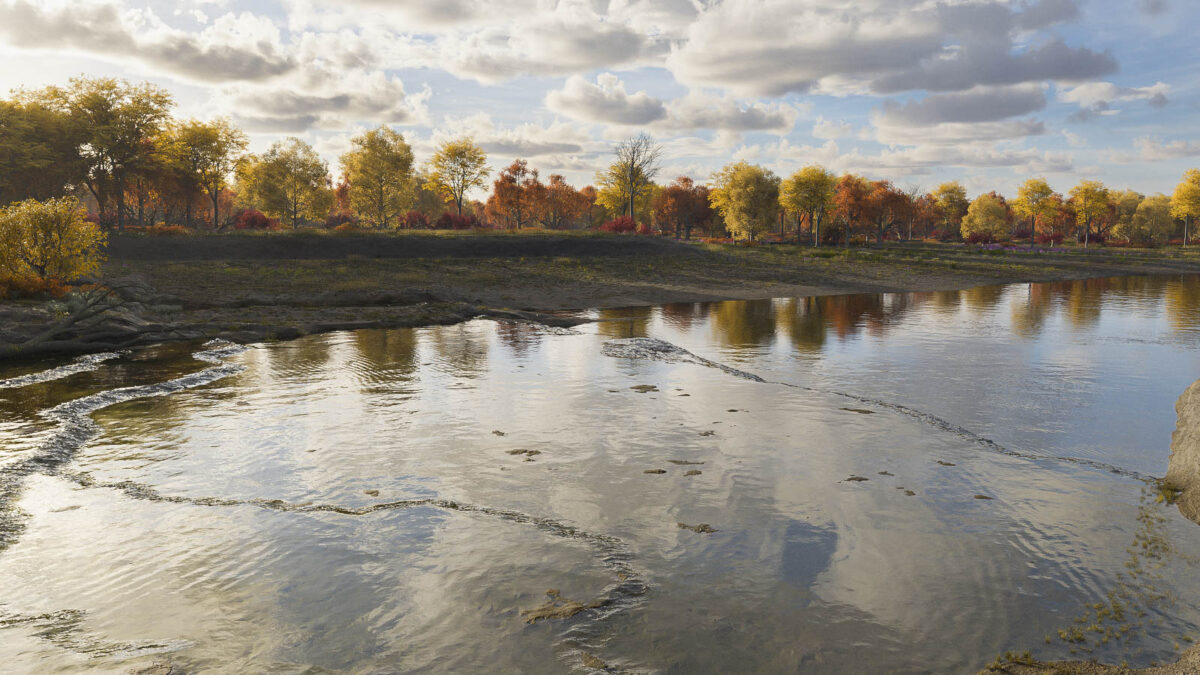
The same view as above, with water surfaces and foliage added to the scene. This reconstructed landscape is similar to the one that would have greeted visitors to the Upper Falls of the Genesee before the village of Rochester was founded. The rim of the final ledge or “rift” of the Upper Falls angles from the center of the image to the lower right, and a dense, swampy forest covers the opposite bank. (Rendering by Steve Boerner.)
Once the base terrain was done, it was just a matter of adding surface textures, water, and foliage.
At that time the landscape would have been covered by old-growth forest. In a letter to his father in Connecticut, Hamlet Scrantom, who operated one of the first sawmills near the village, wrote that “the country is . . . timbered with all kinds of ash, whitewood [softwoods such as pine], chestnut, hickory, black walnut, &c., and many trees of an enormous size.”4
By 1822 much of this timber would be felled to make way (and to provide building material) for the new village.
The scene’s point of view looks west from the east bank of the river. It is similar to the reconstructed view shown in the previous post; here, the season has been set to late October, the intended date of the final scene.
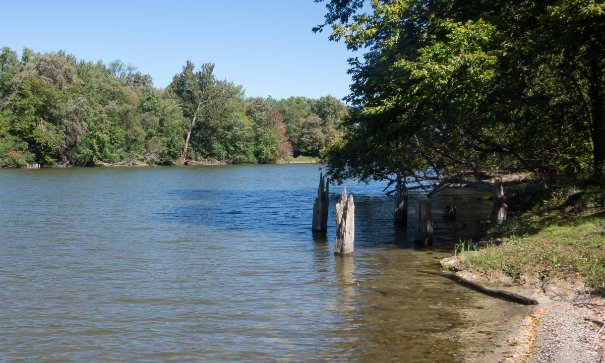
The rocky ledge on the opposite bank is an important feature that is mentioned in early accounts. A matching ledge rises on the east side. That one is not shown: The virtual camera used to make this rendering is positioned right above it.
When planners laid out the final course of the Erie Canal through Rochester, they decided to cross the Genesee here, at the level of the two ledges. This allowed them to maintain the same elevation from the east bank of the Genesee all the way to Lockport, some sixty miles away — the so-called “long level.” As a result, the aqueduct that would carry the canal over the river would have to extend from the rocky ledge on the east side to the one on the west — more than 800 feet — making it the largest masonry structure on the canal.
A fifth member of the commission, Western Union co-founder George H. Mumford, was traveling in Europe and apparently did not contribute to the investigation. ↩︎
Documents of the Assembly of the State of New York, 96th session (Albany: G. Wendell, 1866), issue no. 117, “Report of the Commissioners Appointed to Investigate the causes of the Inundation of the City of Rochester in March, 1865,” page 18; image copy, HathiTrust (https://hdl.handle.net/2027/coo.31924093488496 : accessed 26 December 2024) > image 1132. ↩︎
“Scrantom Letters on the Beginnings of Rochester,” The Rochester Historical Society Publication Fund Series, Vol. 7 (Rochester, New York: Rochester Historical Society, 1928), 174. ↩︎
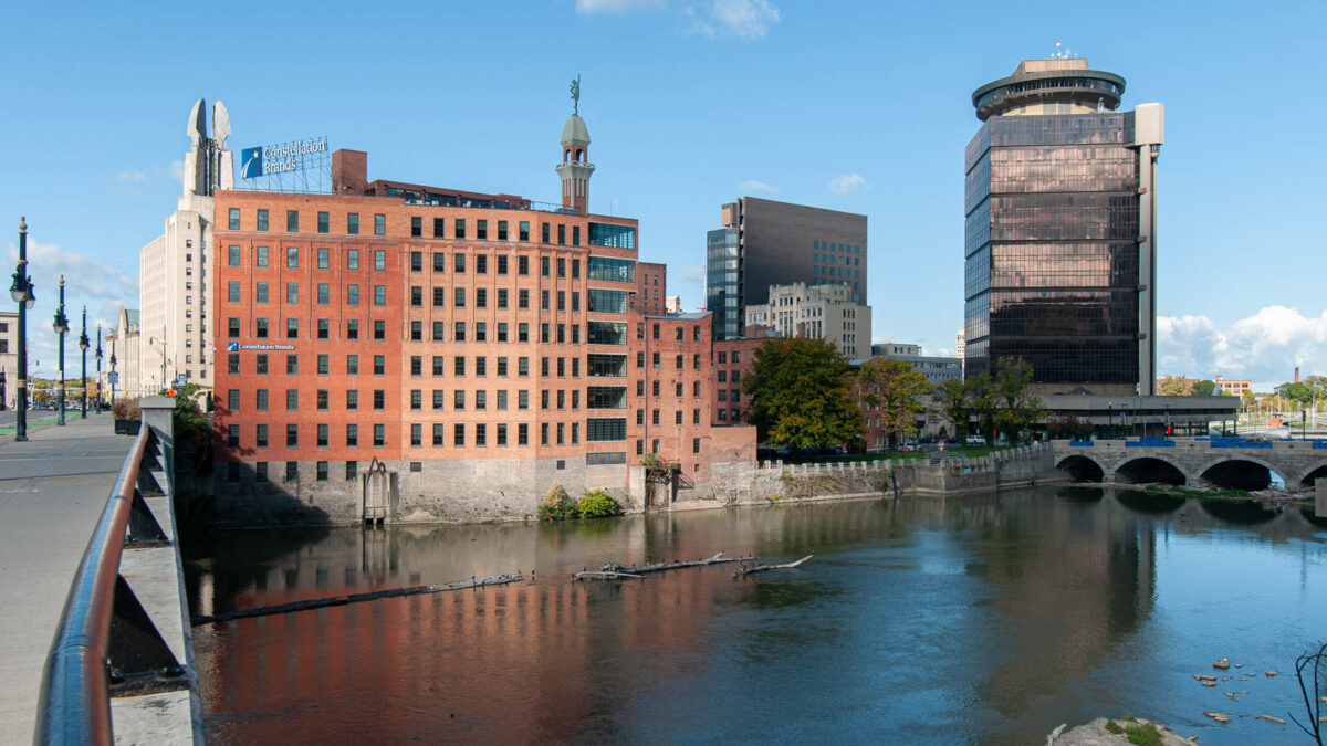
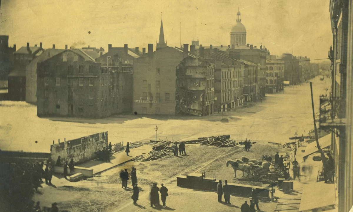
This view of downtown Rochester, New York, looks west across the Genesee River. It was taken from the east end of the Broad Street Bridge, which is built on top of the second Rochester aqueduct, completed in 1842 as part of the first enlargement of the Erie Canal. Mills and other 19th-century industrial buildings, recently renovated to be used as office space, line the opposite bank; the Main Street Bridge, finished in 1857, is at the far right. (Steve Boerner)
The balance of power between Rochester and the Genesee River would finally begin to shift after 1865.
The river was becoming an increasingly unruly neighbor. Freshets in 1817 and 1819 swept away buildings and damaged mills and millraces. Another in 1835, described by Rochester chronicler Henry O’Reilly as “the greatest flood ever known in the Genesee River,” undermined the west abutment of the second Main Street bridge. The bridge’s successor was carried off by another flood in 1857.1
Observers blamed human activity — clearcutting forests and draining wetlands, and construction of bridges, levees, and other obstructions — and warned that it would only get worse. But no one was prepared for the flood of 1865.
That March the river, swollen by an early spring thaw, roiled through the city. It inundated the new Main Street bridge, undermined buildings on both banks, and nearly crested the parapets of the second aqueduct, 27 feet above the riverbed. It was the most destructive flood in the city’s history, causing an estimated one million dollars in damage.2 In response, a commission was appointed by the state to investigate its causes and to recommend measures to prevent it from happening again.
Their report, published the following year, included a list of seven commonsense remedies that included dismantling obstructions, erecting movable dams, and building retaining walls. But in a supplemental report, Isaac F. Quinby, a mathematics professor at the University of Rochester who had assisted with the committee’s investigations, urged the city to take more drastic action: “To blast out a channel along the axis of the river from High Falls to a point about half way between Main street bridge and the aqueduct, or still better, to a point above the latter structure.” The channel would be seventy feet wide at the top and fifty feet wide at the bottom. Its average depth would be ten feet. Excavating it would be expensive, Quinby warned: An estimated 54,222 cubic yards of rock would need to be removed and 2,926 cubic yards of masonry retaining walls built, all at a cost of $121,611. But if it could be accomplished, his plan would increase the river’s capacity and might spare the city from future inundations.3
But Quinby’s plan was shelved, and for the next several decades the local government did almost nothing to protect the city from high water. The floods became more frequent. From the end of the Civil War to the turn of the century the Genesee inundated nearby neighborhoods nine times. In March 1902 a flood nearly as destructive as the one of 1865 swept through downtown; it was followed by another in July — incredibly, during the high summer season. In February 1904 the river, choked with ice, struck again.4
In 1905 another commission was appointed and another report compiled. Of the seven flood control recommendations made in 1866, the new commissioners noted, only three had been completed and another “partly accomplished.”5 But their report went nowhere; nothing more was done.
The flood of March 1913 would be the wakeup call.
The weather system that created it extended from the lower Ohio Valley to western New York. Over several days a series of storms funneled along a low-pressure trough delivered high winds, tornadoes, hail, and sleet throughout the Midwest and South. Up to nine inches of rain fell on Indiana, Ohio, and northwestern Pennsylvania. Rising water trapped thousands of people; newspapers reported that up to two hundred died in Dayton, Ohio, when fire broke out within the submerged part of the city.6
The Great Flood of 1913 remains one of the most widespread natural disasters in the history of the United States. Newspaper editors, running out of ways to describe the devastation, compared it to the Johnstown Flood of 1889 and the Great Galveston Storm of 1900. Recent estimates of the number of people killed range from 650 to more than 900.7
The record rainfall and resulting runoff flooded communities and interrupted train schedules throughout western New York. In Rochester, on the edge of the storm system, the Genesee River overflowed its banks and filled nearby basements and streets with water. But there were no fatalities.
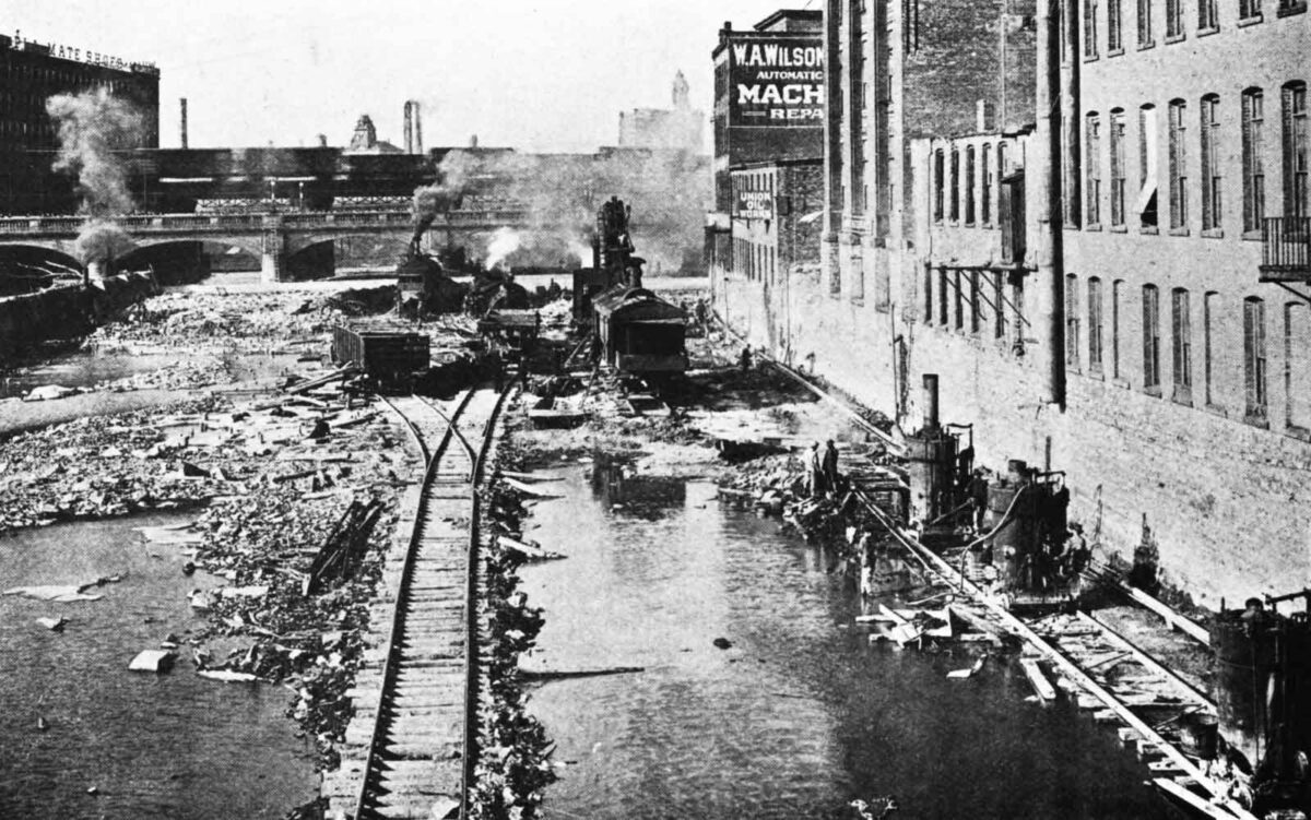
Steam shovels load broken stone into railroad cars in the bed of the Genesee River in October 1915. The view, probably from the Andrews Street Bridge, looks north toward the old Central Avenue Bridge. Channeling machines, lower right, cut slots to square off the cut and protect the building foundations. (Annual Reports of the Department of Engineering for the City of Rochester, 1914–1916, via Google Books.)
A local newspaper quoted a visiting “Pittsburgh engineer” who, when asked how such events might be averted in the future, recommended straight away that “the river bottom ought to be blasted out from Court Street to the Upper Falls.”8
The Common Council at last was roused to take action. It may have been stung by criticism from local merchants, including the Front Street clothing salesman who posted signs in the windows of his flooded store that read: “Water in here Friday 10 p.m., 4 feet. Damage probably $3,500. Why didn’t the city build retaining walls along the river instead of one-half million Exposition Park?”9 Or perhaps council members looked to Dayton and realized that next time Rochester might not be so lucky.
I. F. Quinby’s nearly fifty-year-old plan was dusted off and that December — nine months after the floodwaters receded — the council approved a contract to deepen the riverbed.10
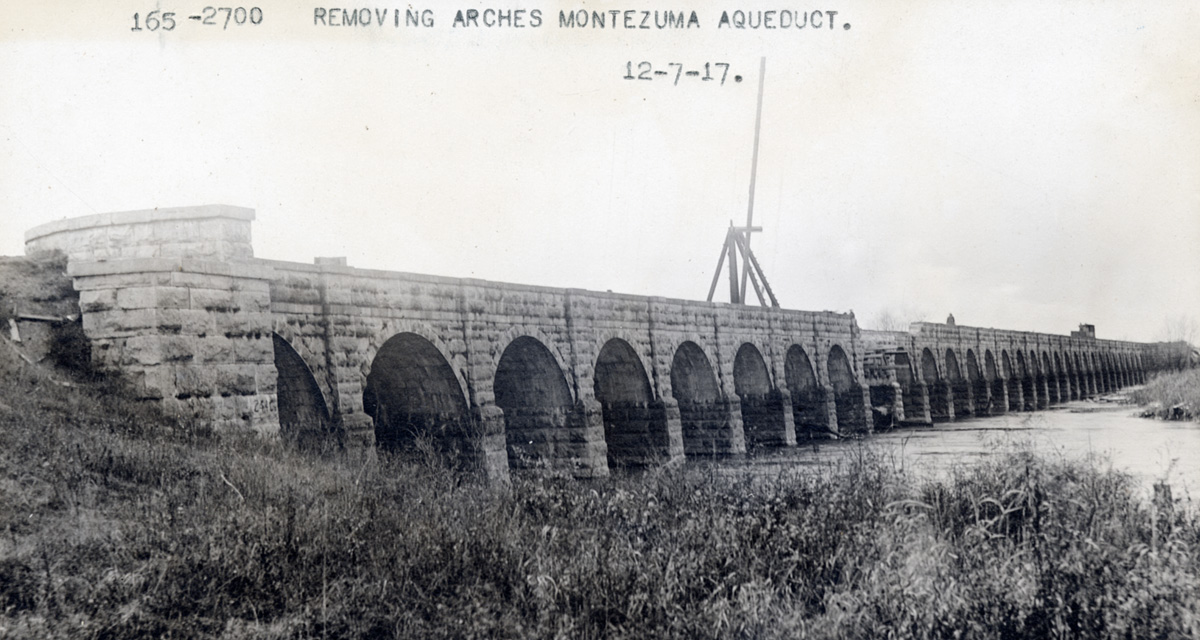
By now the scale of the project had changed dramatically. The excavation would extend from bank to bank, an average width of 240 feet, from just above Court Street to the brink of the High Falls, a distance of 2,700 feet.11
Contractors constructed a dam down the center of the river so it could be diverted first to one side, then the other, exposing the rocky bed.12 For more than five long years city residents endured the constant din of drilling and blasting and the incessant hammering of steam-powered channeling machines. By the spring of 1919, when the last contract was completed, more than 150,000 cubic yards of rock and earth had been removed — nearly three times Quinby’s 1866 estimate — and the project’s cost had soared to nearly a million dollars.13
The final depth of the excavation is not easy to pin down. The original ordinances specified that the riverbed would be lowered an average of five feet from above the aqueduct to the brink of the High Falls.14 Estimates based on the geology of the riverbed and gorge indicate that the High Falls themselves were lowered about ten feet.15
Within a few years the Court Street Dam would be built in downtown Rochester as part of the new Barge Canal system, which would replace the old Erie Canal and also provide a measure of flood control. The final touch would be added in 1952 with the completion of the Mount Morris Dam, thirty miles south of Rochester. This 230-foot-high dry gravity dam serves as the ultimate backstop, impounding high water during extreme weather events to reduce flooding and protect property from Mount Morris to Lake Ontario.
The Genesee River had finally been tamed, and in the process its historic appearance was permanently changed. This was especially true in downtown Rochester where, for all practical purposes, the river’s channel was by now completely man-made.
This reconstructed view of the Genesee River in 1804 uses the same vantage point as the photograph of downtown Rochester at the top of this post. Less than twenty years from now, engineers designing the Erie Canal will put the first Rochester aqueduct right here, where it will bridge the 800-foot gap between the near bank and the rocky ledge in the distance. (Digital landscape by Steve Boerner)
To help you imagine the extent of these changes, just pretend for a moment that you are accompanying Nathaniel Rochester, William Fitzhugh, and Charles Carroll on their first visit to the Falls of the Genesee. Emerging from the dense forest on the east bank, you are greeted by a landscape much like the one shown here.
The last shelf of the falls reaches across the river to the opposite bank, which rises gradually to the foot of a low, stony ledge. This nondescript feature, which eventually will be buried beneath the city of Rochester, will play a role in the development of the village along with its vibrant flour-milling industry and, eventually, the construction of the Rochester aqueduct.
The year is 1804. Soon a stream of incoming settlers, tentative at first and then becoming more steady, will start the long process of transforming the landscape and river.
Henry O’Reilly, Settlement of the West: Sketches of Rochester; with Incidental Notices of Western New-York (Rochester, New York: William Alling, 1838), 351. Dorothy S. Truesdale, “Historic Main Street Bridge,” Rochester History 3 (April 1941), 12. Report of the Committee on Investigation of Flood Conditions Affecting the City of Rochester, N. Y. (Rochester, New York: W. W. Morrison, 1905), 8; image copy, HathiTrust (https://hdl.handle.net/2027/uc1.$b77585 : accessed 29 November 2024) > image 20. ↩︎
Annual Report of the State Engineer and Surveyor of the State of New York for the Fiscal Year Ending September 30, 1896 (Albany: Wynkoop Hallenbeck Crawford, 1897), 33; image copy, HathiTrust (https://hdl.handle.net/2027/mdp.39015067178494 : accessed 29 November 2024) > image 53. ↩︎
Documents of the Assembly of the State of New York, 96th session (Albany: G. Wendell, 1866), doc. no. 117, “Report of the Commissioners Appointed to Investigate the Causes of the Inundation of the City of Rochester in March, 1865,” p. 23–24; image copy, HathiTrust (https://hdl.handle.net/2027/coo.31924093488496: accessed 29 November 2024) > images 1141–1142. ↩︎
Report of the Committee on Investigation of Flood Conditions Affecting the City of Rochester, N. Y. (Rochester, New York: W. W. Morrison. 1905), table, 45–46; image copy, HathiTrust (https://hdl.handle.net/2027/uc1.$b77585 : accessed 29 November 2024) > images 75–76. ↩︎
“Hotel and 200 People Burned,” The (Rochester, New York) Democrat and Chronicle, 27 March 1913, p. 2, col. 2; image copy, Newspapers.com (https://www.newspapers.com/image/135734903 : accessed 29 November 2024). ↩︎
“After Attack on City River Gives Ground,” The (Rochester, New York) Democrat and Chronicle, 30 March 1913, p. 27, col. 1; image copy, Newspapers.com (https://www.newspapers.com/image/135734990 : accessed 29 November 2024). ↩︎
“Final Ordinance 4379: Construction of Movable Dams and Deepening Genesee River Bed,” Proceedings of the Common Council of the City of Rochester: 1913 (Rochester, New York: Rochester Herald Press, 1914), 612; image copy, Google Books (https://www.google.com/books/edition/_/YWkwAQAAMAAJ?hl=en&gbpv=0 : accessed 29 November 2024). ↩︎
“Genesee River Flood Protection for the Year 1916,” Annual Reports of the Department of Engineer of the City of Rochester for the Years 1914, 1915 and 1916 (Rochester, New York: John P. Smith, 1917), 5: image copy, Google Books (https://www.google.com/books/edition/Annual_Report/-uA2AQAAMAAJ?hl=en&gbpv=0 : accessed 30 November 2024). ↩︎
The foundation of this dam can still be seen during periods of low water. ↩︎
“Deepening Genesee River for Flood Protection,” Annual Reports of the Department of Engineering of the City of Rochester: Years 1917, 1918, 1919 and 1920 (Rochester, New York: John P. Smith, 1921), 6; image copy, Google Books (https://www.google.com/books/edition/Annual_Report/Kd42AQAAMAAJ?hl=en&gbpv=0 : accessed 29 November 2024). “H. W. Rippy Obtains Figures,” The (Rochester) Democrat and Chronicle, 1 November 1919, p. 15, col. 2; image copy, Newspapers.com (https://www.newspapers.com/image/135411869 : accessed 29 November 2024). The newspaper reported that the city paid $839,781.49; adding $115,000 paid to cover a loss by the contractor brings the total to $954,781.49, or more than $16 million in today’s currency: “CPI Inflation Calculator,” U.S. Bureau of Labor Statistics (https://www.bls.gov/data/inflation_calculator.htm). ↩︎
Report by the public works committee, Proceedings of the Common Council of the City of Rochester: 1913 (Rochester, New York: Rochester Herald Press, 1914), 611; image copy, Google Books (https://www.google.com/books/edition/_/YWkwAQAAMAAJ?hl=en&gbpv=0 : accessed 29 November 2024). ↩︎
Thomas X. Grasso, “Geology and History of the Rochester Gorge, Part One.” Rochester History 54 (Fall 1992), 21. ↩︎
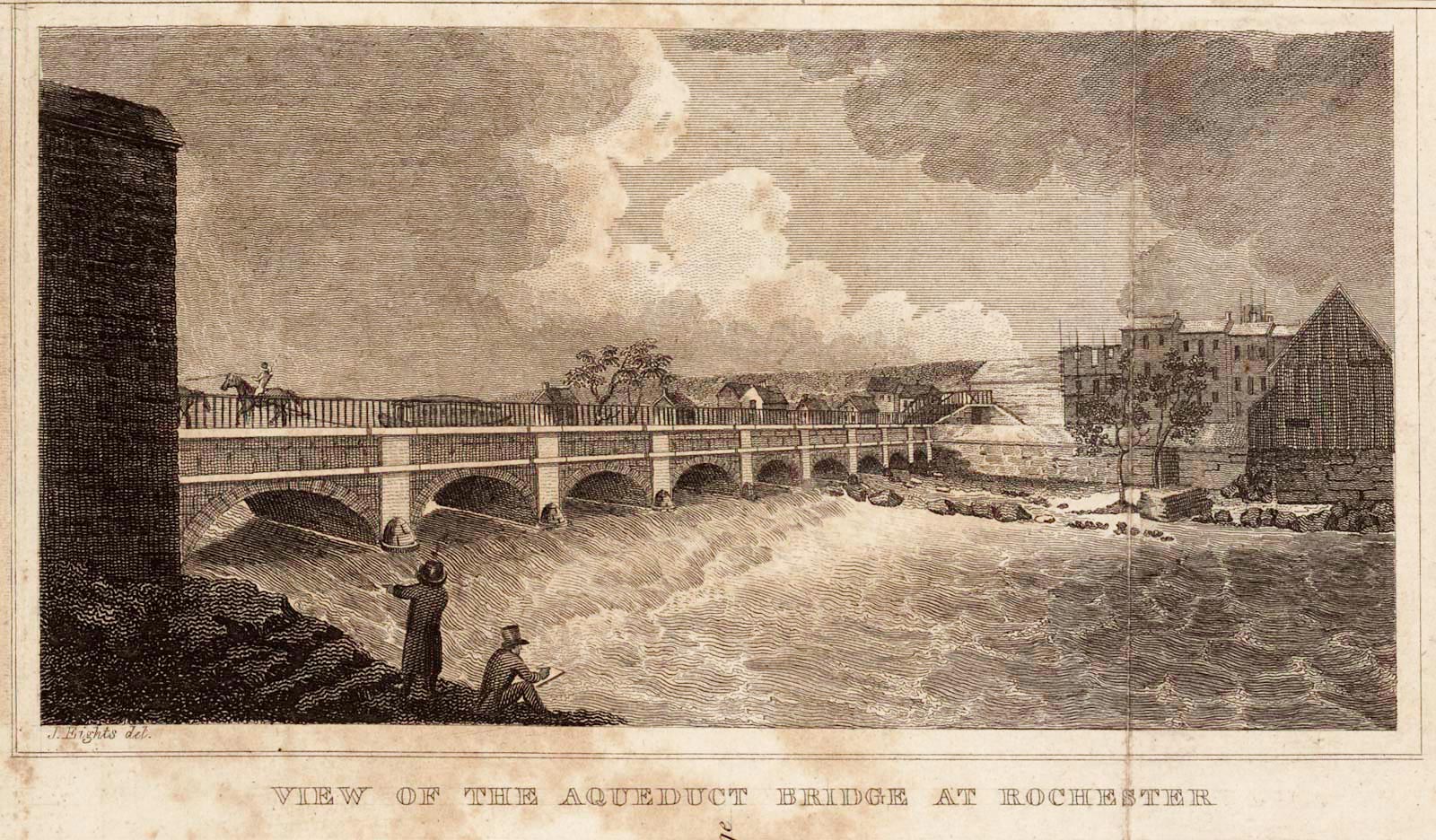
James Eights recorded this view of the “aqueduct bridge” from the east bank of the Genesee River around 1825. A packet boat drawn by a team of horses passes over the aqueduct while the river cascades over one of the shelves of the Upper Falls below. The large stone building at the left is a brewery. Mills, warehouses, and residences crowd the opposite bank. (Library of Congress)
The great aqueduct over the Genesee River at Rochester was built over fifteen months, from July 1822 to September 1823.
Actual construction, however, took about eight months. Though work elsewhere along the canal line began each year in early spring, the aqueduct builders in Rochester waited till July, when the level of the river dropped. Most of its water was then diverted into the millraces on the east and west banks, allowing access to the rocky riverbed.
The contractors — Alfred Hovey, Abel Wethey, and a handful of others — may have been under pressure to finish the job quickly. The state’s canal commissioners hoped to open the entire canal from Albany to Buffalo by the end of 1823. They did not know that difficulties further west at Lockport would delay everything for another two years. In 1822, they may have assumed that Rochester would be the bottleneck.
Already an entire year had been wasted. Hovey and Wethey’s contract represented the second attempt to cross the river. The first, commenced the previous year by William Brittin, had failed disastrously. Ill-prepared and underfinanced, Brittin had managed to erect only a culvert and the eastern abutment by the time the river rose that fall. During the ensuing winter it carried off the abutment, leaving behind a few straggling anchor bolts bent over by the force of the current. That December, Brittin died.
The partners who picked up the contract spent much of the winter of 1822 searching for a convenient source of suitable building material — stone that was durable, easy to work, and that could be quarried in blocks large enough to withstand the force of the river’s annual floods. They found this durable material, or so they thought, at the bottom of the Genesee River gorge: a layer of red Medina sandstone.
Most of the stone used to build the aqueduct would come from here. After being cut from the quarry, the large red blocks, from two to five feet thick and weighing several tons apiece, were somehow hauled to the brink of the gorge — a near-vertical ascent of almost 200 feet. Or perhaps they were floated downstream to Hanford’s Landing, where skids had been built to convey heavy items between the top of the gorge and the water’s edge. Either way, the blocks then would have been hauled by ox-drawn sled to the aqueduct site three miles away.
In all, more than 13,500 cubic yards of rock would be used to build the aqueduct, enough to fill a football field with a stack of stone blocks six feet high. As the stones slowly piled up on the east and west banks of the river, workers used black powder to blast away the shelves of the Upper Falls that were in the way.
Much of the quarrying and blasting — the most difficult and dangerous work — was done by convicted criminals from the new state prison at Auburn.
Stone construction is an ancient art; the methods used by the aqueduct builders would have hardly changed for thousands of years. First, the rough blocks were cut and dressed by skilled masons, who took particular care to fashion the wedge-shaped voussoirs to precisely fit into each arch. Then the heavy blocks were transported up to four hundred feet out over the riverbed and delicately lowered into place. Tolerances were measured in fractions of an inch. Aside from the animal teams used to haul the stones to the site, the work was entirely powered by human effort.
They worked quickly, setting the abutments and piers firmly into the rocky bed of the river and erecting the nine main arches, each of which took only a few days to complete. By the end of 1822 all of the arches and the walls between them were finished.
The water table, parapets, pilasters, and coping were assembled from enormous slabs of gray Cayuga County limestone, delivered by way of the partially completed canal from quarries sixty miles away. The aqueduct was finished by September 1823. It opened amid a shower of toasts the following month.
Erie Canal engineer David Bates described the completed work in the Rochester Telegraph:
“This stupendous fabric, which forms a prominent link in the great chain of our inland communication, is built on one of the rifts which compose a part of the extensive falls of the Genesee river.
“The Aqueduct, from the eastern extremity of its parapet walls to its western termination, is 804 feet long, and is built on eleven arches; one [on the east side] of twenty-six feet chord, under which passes the water necessary for a number of important flouring mills, &c., nine of fifty feet chord, and one on the west side of the river of thirty feet chord, under which passes water for a number of flouring mills and other hydraulic establishments. . . .
“The structure is founded on solid rock, in which nitches [sic] were cut to found the piers, which are thirty-six feet long and ten feet wide, including at each end a pedestal and dome, out of which rises a pilaster. The height of the piers is about four and an half feet; the rise of the arch eleven feet; its thickness at the foot three feet; at the apex, two and an half feet. The parapet walls or sides of the trunk, are five and an half feet high, including the coping, which is so constructed as to form a capital to tile whole trunk. The whole of this immense building is of cut stone; many of them, particularly the piers, of very great size. . . .
“On the north wall, which is of sufficient thickness for the towing path, is an elegant iron railing; and at the west end the whole is terminated by a highway and towing-path bridge of the most solid and elegant workmanship.”1
Alas, the aqueduct’s flaws would soon become apparent. They were several, all serious.
First, integrating the existing channel of Elisha Johnson’s north-south millrace into the east-west alignment of the canal had resulted in a ninety-degree turn at the aqueduct’s eastern end that would snarl traffic and prove hazardous for large boats.
Second, the seventeen-foot width of the aqueduct waterway meant that canal traffic across the river would be one-way. Eastbound boats would have to wait for westbound boats, and vice-versa. Rochester was a busy canal port. Basins near both ends of the aqueduct would have been crowded with passenger and freight traffic. As much as any other feature of the canal, the aqueduct’s narrow width would create endless bottlenecks and fistfights among canal-boat bullies.
The final insult: Not only was the aqueduct the wrong size and possibly built in the wrong place, it leaked. This may have been partly due to its rapid and probably substandard construction. But the main culprit was the red Medina sandstone of which it was built, a poor choice of building material that turned out to be porous. The aqueduct began to crumble as Rochester’s yearly freeze-thaw cycle broke up the stones and the water lime that filled the gaps between them.
By the 1830s engineers began to draw up contingency plans in case the aqueduct failed completely. Its replacement, finished in 1842, stands to this day: a testament to professional engineering, quality workmanship, and the tough limestone of which it is made.
A German tourist by the name of A. Duttenhofer sketched the aqueduct from the west bank in 1826, apparently from an upper floor of one of the new buildings on Mill Street. Jonathan Child’s sawmill straddles the raceway at lower left, behind an empty canal boat tied up in Child’s Basin. Gristmills and sawmills line the opposite bank, while others crowd the south wall of the aqueduct. (New York State Library)
Rebuilding the aqueduct
You may have guessed by now that the construction of the first Rochester aqueduct will be the subject of my next landscape.
All of my images are based as much as possible on original research, but I realized early on that this one would be in a league of its own. There were many stories to follow: The construction of the aqueduct, the founding and early growth of Rochester, and the development of the flour milling industry, to name just a few. Following these stories took a few years and involved several trips across New York state to visit libraries, historical societies, and archives. Many hours were spent online going through newspapers, property deeds, state prison records, and period textbooks and treatises on carpentry, masonry construction, and civil engineering.
I’m planning to post more frequently as work on the landscape continues. Brief historical narratives will fill out the broad overview given here and will alternate with updates on the image itself.
If you haven’t already, please go back and read “There for the Taking,”“On the Brink,” and “Over the River.” These establish some historical context and set the stage. If you like, you can use the form on this website’s home page to subscribe to future posts.
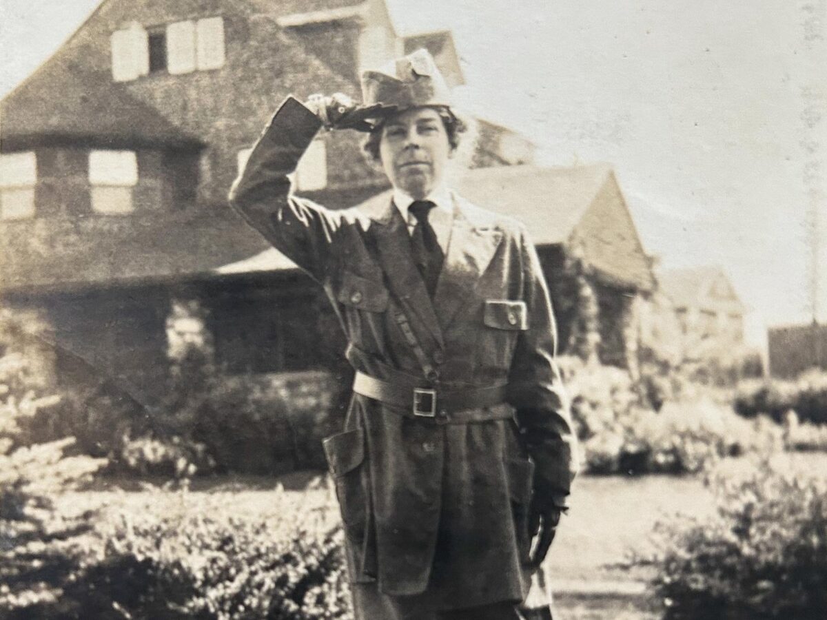
Maude Motley, wearing her Red Cross uniform, salutes the camera while standing in front of one of her family’s summer homes in Kennebunk Beach, Maine. This photo probably was taken during or shortly after World War I. (Courtesy of James Pendleton)
Anyone seriously interested in the history of Rochester, New York, sooner or later will encounter a remarkable essay that appeared in the spring of 1932.
“The Romance of Milling: With Rochester the Flour City” was published in the first volume of the Centennial History of Rochester, New York. It was written by Maude Motley, who in the previous century had been born into one of the city’s most prominent milling families.
Raised in an environment of wealth and privilege, her formal education seems to have ended by age twelve. But she was a voracious reader and a diligent researcher. She would have drawn upon earlier histories and contemporary trade publications as well as her own memories and those of her family and acquaintances. Her narrative is straightforward, heartfelt, and overlaid with a generous gloss of civic pride.
“It is of exciting interest to trace the progress of flour milling in the Genesee Country wilderness during those amazing decades which led to Rochester’s being named THE FLOUR CITY, as the greatest milling center of the world,” she wrote. “Such a narrative should include a recognition of the sterling character of the pioneers in the milling industry who originated the ideal, if not the slogan, that Rochester-Made Means Quality.”1
Nearly a century after its publication, “The Romance of Milling” remains one of the finest accounts that we have of flour milling in Rochester. There may be many reasons why this is so, but they all boil down to this: Maude Motley was the perfect witness. She was an insider, she was prepared, and she was determined to tell the story.
Across the water
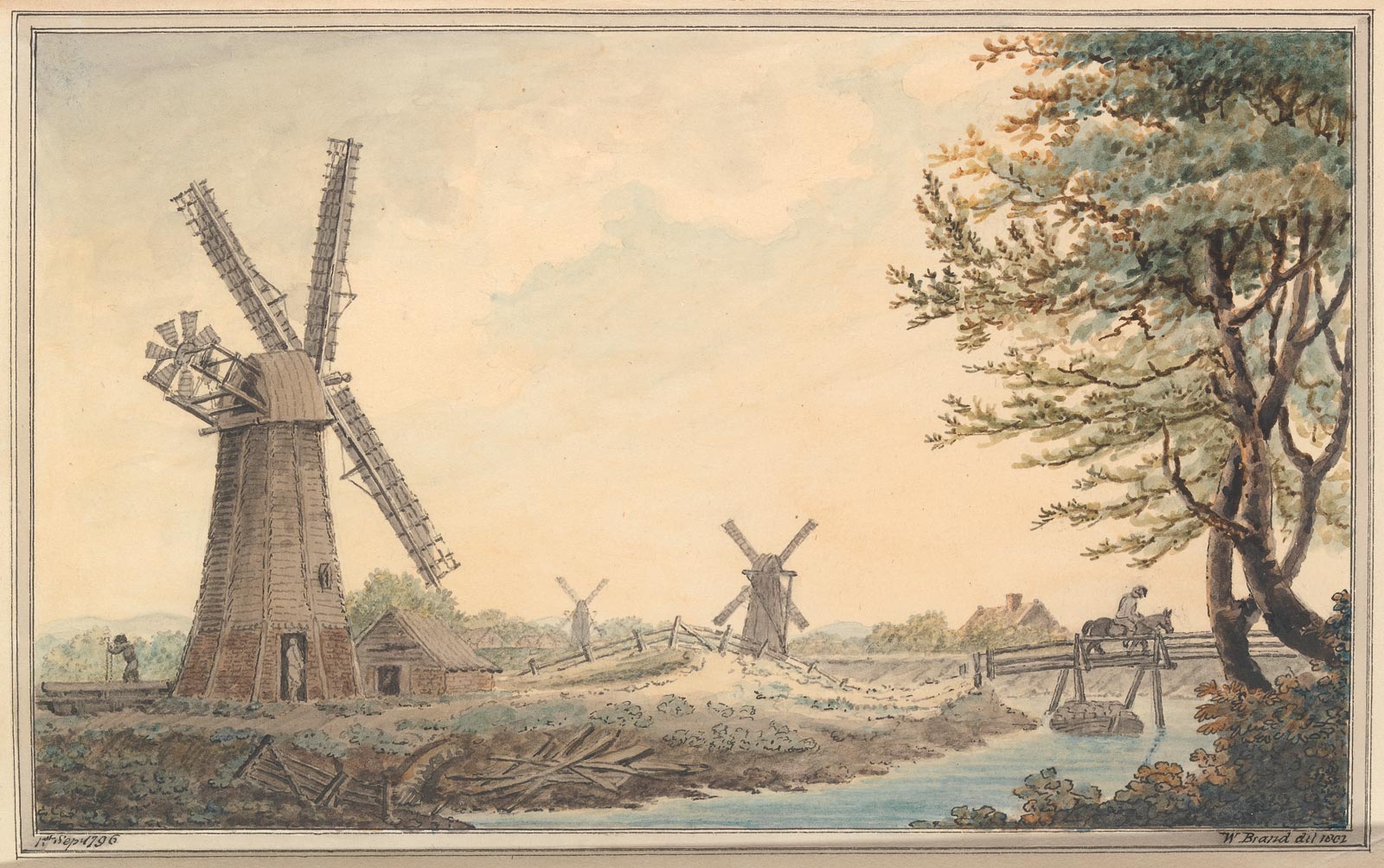
Windmills cluster along the banks of the River Witham near Chapel Hill, Lincolnshire, in this 1796 watercolor sketch by William Brand. As a young man George Motley would have learned the miller’s trade by working in windmills much like these. Chapel Hill was about thirty miles from his home in Covenham St. Bartholomew. (“Sir Joseph Banks’s Fishery Book of the River Witham in Lincolnshire,” Yale Center for British Art, Yale University)
The Motley family’s deep ties to the milling industry extended back to Covenham St. Bartholomew, a small village near the east coast of England in Lincolnshire. There, in September 1834, a son was born to George and Mary Motley. They christened him George, after his father and grandfather.2
The 1841 English census for Covenham St. Bartholomew lists the household of one George Motley, age thirty: his wife, Mary, also thirty; George, six; Frances, four; and Ann, one; along with George the elder’s occupation, “Miller.”3
In those days, watermills would have been impractical in Lincolnshire, which is mostly flat and lacks fast-flowing water. So wind power was harnessed instead — just like it was in Holland — to pump water, saw timber, and grind flour. Hundreds of windmills were scattered about the countryside near young George’s home. Growing up, he would have learned the trade by working in one of those windmills alongside his father.
At the age of nineteen George decided to “seek his fortune across the water” and join a maternal uncle who operated a water-powered flour mill in Canada.4
His first attempt to cross the Atlantic ended in disaster when his ship, the Black Hawk, ran headlong into a “perfect hurricane” two weeks out of Liverpool. Within hours the wind sheared off all three masts, tore up the deck and allowed “the water to flow down a perfect avalanche” into the hold. Steerage passengers were set to work bailing and pumping. It was only by extraordinary good fortune that passing ships encountered the sinking vessel and stopped to help. Incredibly, all of the passengers and crew aboard the Black Hawk, some 858 souls, were rescued.5
George sailed back to Falmouth on the eastbound barque Caroline along with 124 other survivors.6 Undaunted, he returned to Liverpool that fall, boarded the packet Andrew Foster, and once again was bound for the New World. This time his ship managed to limp into New York harbor after an arduous seventeen-day crossing that included yet another gale.7 He would have marked his twentieth birthday on the high seas.
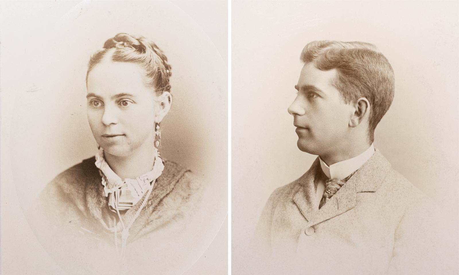
Ann Jane Haughton Motley and George Motley, photographed soon after their arrival in Rochester. (Rochester Museum & Science Center)
After landing in New York, George would have made his way north to join his uncle in Belleville, Ontario. But before long his uncle’s mill failed and “he was sunk again — only a month or so after he had married a seventeen-year-old orphan girl, Ann Jane Haughton, a native of Montreal.”8
Suddenly in need of work and no doubt determined to break his string of bad luck, George, along with Ann, her sister Ellen (“Nelly”), and brother-in-law William Kingston, packed up and moved across the border to Rochester, New York, a bustling mill town known as the Flour City. Soon George was working at the Frankfort Mills on Brown’s Race.9
Flour City
The white settlers who arrived at the falls of the Genesee in the early nineteenth century were eager to exploit the river’s potential as a source of power. But development came in fits and starts, impeded by war and the wild country that surrounded and isolated the struggling settlement. By 1823 seven commercial mills were in operation in or near the village of Rochesterville. That year they ground 64,114 barrels of flour for export on the Erie Canal.10
The canal would accelerate Rochester’s transformation from village to city. As its population grew — from 1,502 in 1820 to 36,403 in 1850 11— water power drove all sorts of industries: triphammers, clothing works, and oil mills; factories for the manufacture of nails, window sashes, barrels, and pails.12 And, of course, flour mills: Fed by winter wheat harvested in the Genesee Valley, Rochester’s flour mills increased in size and number. By 1850, twenty-two mills were manufacturing more than 600,000 barrels of flour annually.13
But Rochester’s career as the Flour City would be brief. Raised in soil depleted by careless farming and ravaged by insects, the Genesee Valley’s wheat harvests by the late 1850s were in free fall.14 The canal itself turned out to be a mixed blessing. It allowed Rochester’s mills to replace local wheat with grain from Ohio and points west, but it also encouraged large-scale milling to take root near the rich and rapidly expanding wheatfields of the prairie states. Minneapolis, Milwaukee, St. Louis, and even nearby Buffalo all surpassed Rochester, taking advantage of low shipping rates on the Erie and other canals (and soon, railroads) to move their product to Eastern markets.
George Motley would have been aware of these developments as he worked his way up at the Frankfort Mills. His faith in the industry must have never wavered, though, for in 1863 he bought a stake in the company.15 He was ambitious and smart, and seemed to understand that the new firm of Moseley & Motley would have to grow and innovate to weather the Rochester milling industry’s inevitable decline. In 1871 he patented a new method to extract the heart of the wheat berry during the milling process, which enhanced the whiteness and texture of the flour.16 He later traveled to Europe to investigate roller milling, which used porcelain or steel rollers instead of the traditional flat millstones, and introduced the new process to Rochester. Meanwhile, the company bought another mill and began operating under the trade name of Flour City Mills.17
Family
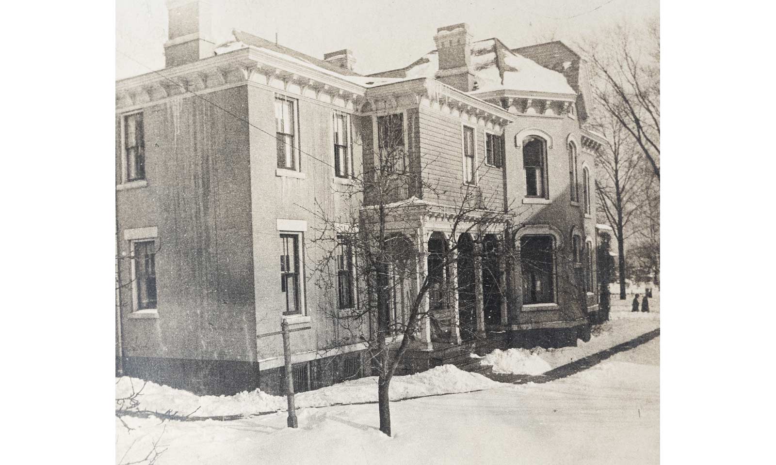
The Motley homestead on Lake Avenue in Rochester was built in 1872. Street numbers were updated as the city grew. Originally at 44 Lake Avenue, the address changed to 96 Lake Avenue in 1884, then to 120 Lake Avenue in 1901. (Rochester Museum & Science Center)
George and Ann Motley settled down to domestic life. Large families were the order of the day and theirs would be no exception. The first child to arrive was Ida, in December 1857. She was followed by Alice, Addie, and Lily, then (finally, in September 1868) a boy, christened George after his father. Then, three more daughters: Eleanor (“Nellie”), Maude (born November 16, 1872), and Jessie. A second son, Albert (“Bert”), was born in September 1877.
To house his expanding family, George in 1872 built a fine brick home on upscale Lake Avenue within walking distance of the mill. The family moved in that October, five weeks before Maude was born.18
In the summer of 1877 Ida married Charles Edwin Angle, who soon went to work for his father-in-law at the mill. The young newlyweds — both were twenty years old — set up housekeeping on Frank Street, just a few blocks west. Addie married a banker, Edward Andrews Webster, in the spring of 1881. They too settled nearby, in a modest frame house on Phelps Avenue. Edward also joined the company, which was gradually becoming a family business.19
George and Ann Motley were members of the Brick Presbyterian Church on North Fitzhugh Street. The striking Romanesque Revival edifice was home to one of the oldest congregations in Rochester. Each Sunday they worshiped alongside many of the city’s most influential families, listening to sermons delivered by the Rev. James B. Shaw. In 1880 George was elected trustee.20
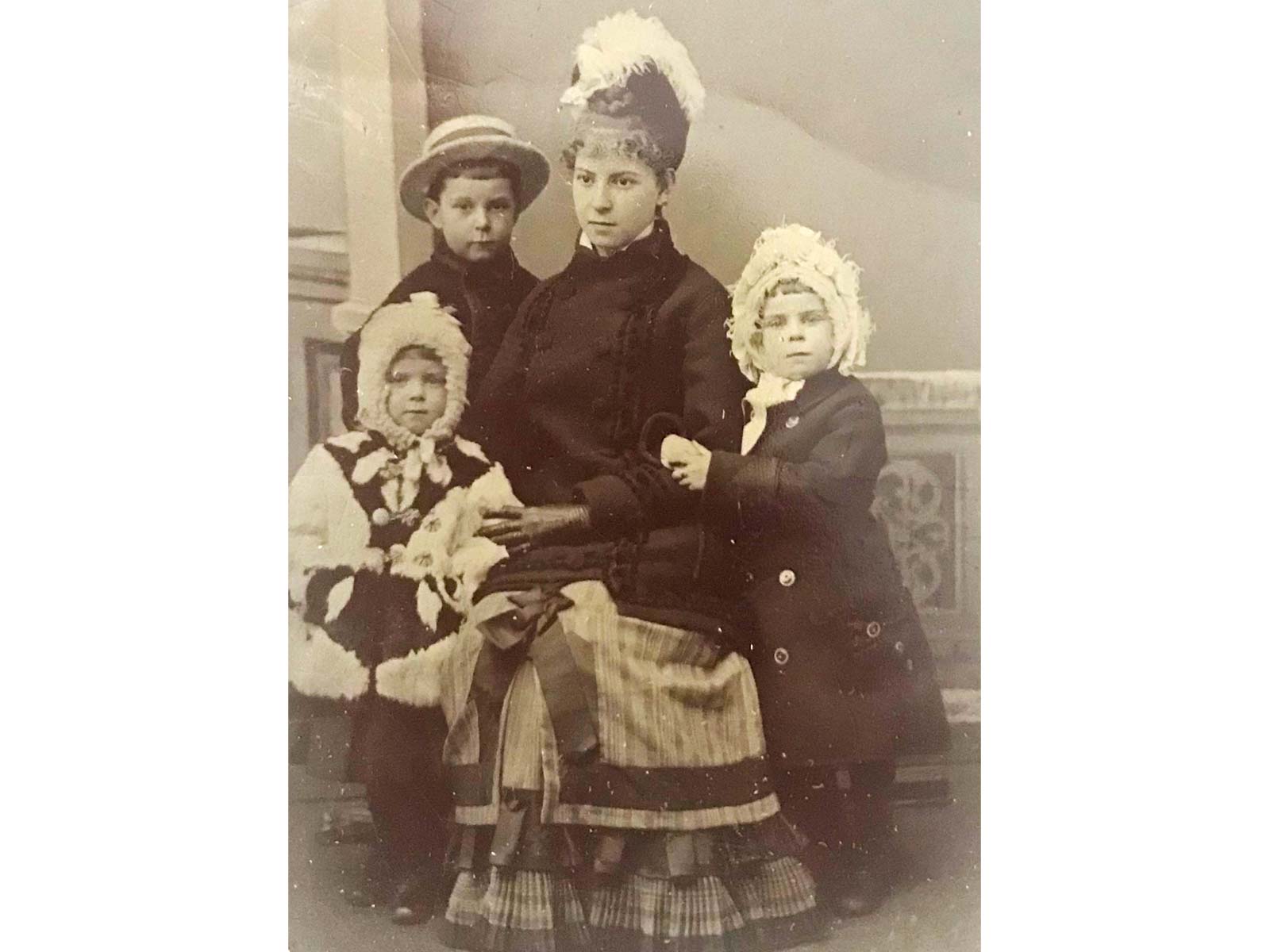
Ida Motley is surrounded by a few of her younger siblings in this undated tintype: Eleanor (“Nellie”), at left in a straw hat; Jessie, left; and Maude, right. (Courtesy of James Pendleton)
By then George Motley had become a successful businessman. He was a pillar of the Rochester milling community and president of the New York State Millers’ Association. Already wealthy, he still had a long career ahead of him. But by 1881 his health was failing; he died, suddenly, at home that Christmas Eve. The cause was heart failure brought on by Bright’s Disease, or inflammation of the kidneys. He was forty-seven years old.21
His death was the second calamity to strike the Motley household that December. Four days earlier, seven-year-old Jessie had died of diphtheria.22
There is no telling what immediate effect this double shock had on the close-knit Motley family. But in the long term George’s departure may have cut short the education of his younger children.
Three of the older children, beginning with Ida in 1872, had attended the Rochester Free Academy, the city’s public high school. Ida did not complete her coursework there, but Alice and Addie did: both graduated in 1876. Young George and Nellie would enroll in 1884. By that December George would drop out to work at the mill; Nellie would go on to graduate four years later. But it seems the remaining children — Lily, Maude, and little Bert — would never attend secondary school. In January 1885 Lily would note that “Maude has not been to school in several months.”23
It’s likely that George Motley had been the force behind his children’s schooling. His own experience may have convinced him of the value of a rigorous education, and he seemed intent on opening up the world to his children. In 1878 he had taken Alice and Addie, still in their teens, on his trip to Europe.24 There is no reason to doubt that he would have shared similar experiences with their younger siblings. For Maude, who was naturally bright and curious, the tragedy of her father’s death would be compounded by the loss of those opportunities.
Life at “96”
Life gradually resumed a routine in the Motley home at 96 Lake Avenue. Though Maude’s formal schooling had ended, she and Bert continued their lessons under the watchful eye of their sister Alice. She had married in 1883 and lived with her husband, John C. Woodbury, across the street.
“I don’t think the fact of Bert and Maude coming to recite to me each morning has been chronicled here,” wrote Alice in March 1885, “They have been coming for some time now, and I think have progressed considerably.” One of her charges, she noted, had a habit of taking shortcuts: “Maude has very quick perceptions but, from that very fact, is much inclined to slur over things and try to grasp the meaning or answer, without any preliminary work.”25
Alice recorded her thoughts on teaching in a journal titled “Chronicle of the Motley Family with Its Branches.” A collaborative effort, it was passed around so each of the children could document their lives a few weeks at a time. The older girls contributed almost all the entries, beginning with Addie on January 1, 1885: “New Year’s Day. Last night we watched the old year out and the new year in. . . . All the family were at our house, 46 Phelps Ave. to tea and we had a very pleasant evening.”26
From then till August 22, when the entries stop, “Chronicle of the Motley Family” opens a window into the lives of an extended upper-class family at the height of Rochester’s Gilded Age.
While Maude attended lessons at Miss Nelson’s Dancing School and accompanied her mother on social calls, her older siblings went on with their own lives. Each day the men worked at the mill, with Sundays off for church and the weekly family dinner at “96.” The women’s days were spent shopping, taking classes in the new fad of china painting, and managing their households. (“Our new ‘domestic’ arrived to-day,” noted Lily on May 8. “Her name is ‘Louise’; she has terra-cotta hair.”)27
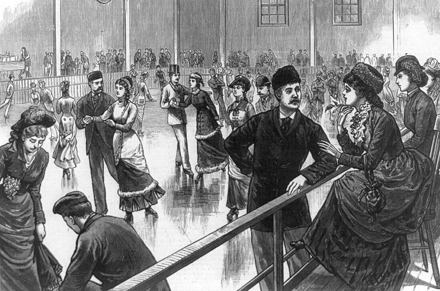
New roller-skating rinks built in Rochester in the 1880s shared some of the features of this fashionable rink in Washington, D.C., including its spacious interior and raised platform for spectators. The article accompanying this illustration in the March 16, 1885, issue of Frank Leslie’s Illustrated Newspaper noted that “the rink is large enough for a regimental drill-room, and under the bright lights and over the polished asphalt floor, the crowds of swaying, swinging and gliding figures have the prettiest possible effect.” (Library of Congress)
Evenings were spent in each other’s company. At home there were sing-alongs and endless rounds of euchre, cribbage, and whist. And the grown children, like the twenty-somethings of any era, made it their business to go out and have fun.
Rochester was more than willing to oblige. Its lively theater season featured performances by the era’s brightest stars. There were minstrel shows and dancing horses. In winter, there were sleigh rides and skating at the Crystal Ice Rink to music by the Union Cornet Band; in the spring and summer, baseball games between the Rochesters and the Stars of Syracuse and the Buffaloes.
Perhaps best of all there was roller skating. Along with the rest of the country, Rochester in the mid-1880s was swept up in a roller-skating craze. Roller-skating rinks were quickly built and offered orchestra music and free skate rentals to attract patrons. The Motleys enthusiastically joined in, sometimes visiting their favorite rink on Washington Street several times a week. The rink boasted an iron truss roof and raised seats for spectators. Admission was fifteen cents.28
Finally, there was church. The Motleys religiously attended Sunday service at the Brick Church, stayed for Sunday School, and often returned again for services during the week. Their lives were anchored by family and church.
Disaster
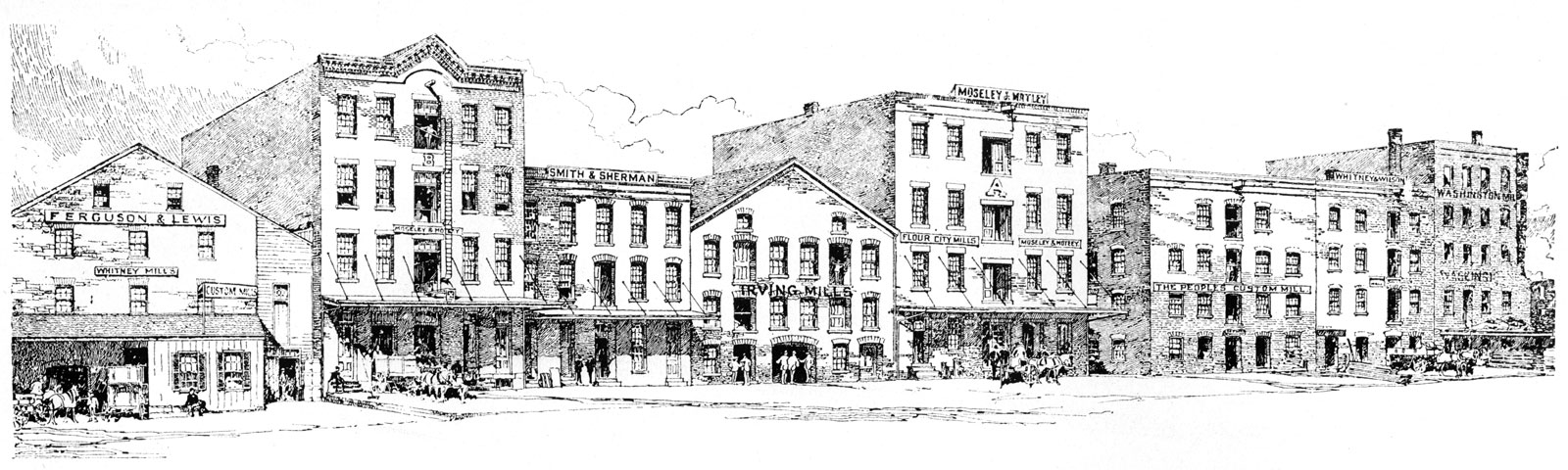
Flour mills lined up along Brown’s Race in Rochester, from left: Whitney Mills, Moseley & Motley Mill “B,” Frankfort Mills, Irving Mills, Moseley & Motley Mill “A,” People’s Custom Mill, Shawmut Mills, and Washington Mills. The gap to the right of the Washington Mills dates the scene sometime after the destruction of the Jefferson and Clinton mills in 1887. (Rochester Historical Society)
In early December 1887 workers blasting a new sewer tunnel on the west side of Rochester fractured a three-inch iron pipe used to deliver naphtha from the nearby Vacuum Oil Company refinery to the Municipal Gas Works about a mile and a half north.29 The gas works used naphtha, a highly explosive petroleum byproduct, to manufacture illuminating gas.
Shortly after noon on Wednesday, December 21, the refinery began sending a large order of naphtha through the pipe. But instead of going to the gas works, it escaped from the broken pipe into the sewer.30
The sewer extended north to Platt Street. There it connected to another that ran east to Mill Street, where several mills, including those of the Moseley & Motley Milling Company, were lined up along the edge of a cliff over the Genesee River. There the sewer tunnel jogged north and dove beneath the Jefferson Mills before exiting from the face of the cliff.31
Around 1 p.m. workers in factories along Mill Street noticed “a queer smell.”
At 3 p.m. the manhole in front of the Jefferson Mills exploded, shattering windows two blocks away and hurling the cover and paving stones high into the air. Workers poured from nearby mills and factories and crowded around the crater, gaping at the flames and black smoke belching out. It was, in the words of a newspaper report the next day, like looking into the “Mouth of Hell.”
Then came the second explosion, more terrible than the first.
To those who witnessed it, the detonation seemed to lift the Jefferson Mills — a substantial stone building — completely off its foundation. When it came crashing down the front wall tottered and collapsed, taking the rest of the building with it.
The explosion blasted stones and barrels of flour into the street and scattered the onlookers gathered there. Among them was Addie’s husband Edward A. Webster, who worked as a bookkeeper at the Moseley & Motley mill. At the sound of the first explosion he had dashed into the street, only to be flung violently against a wall by the second. Suffering a broken arm and leg, and who knows what other internal injuries, he was taken to the city hospital. He died soon after he arrived.32
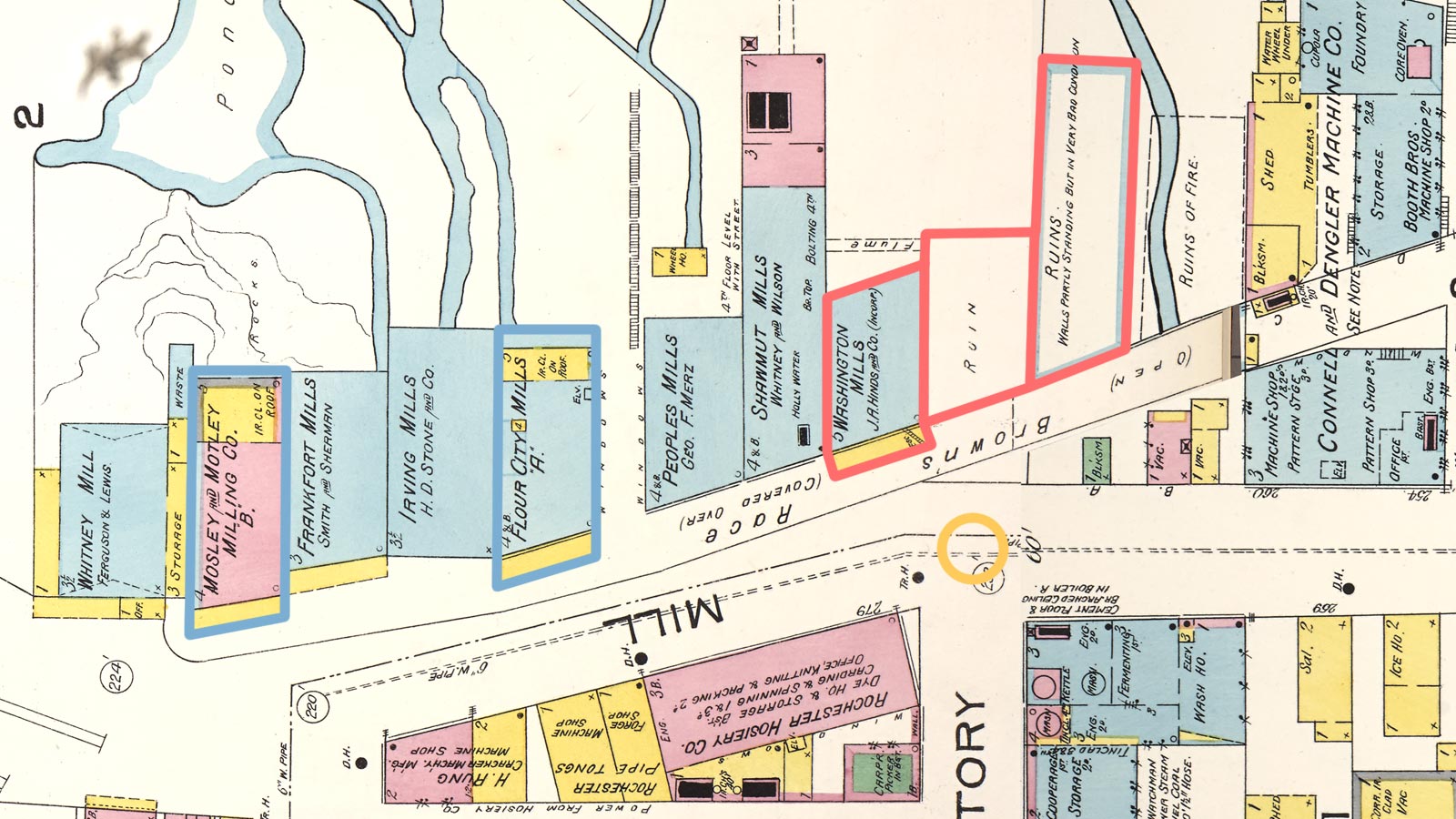
This detail from the 1892 Sanborn Fire Insurance map of Rochester shows the mills along Brown’s Race. North is to the left. The locations of the three mills destroyed by the naphtha explosion are outlined in red; a gold circle shows the approximate location of the crater. Nearly five years after the disaster only the Washington Mills have been rebuilt. The other two lots, where previously stood the Jefferson Mills (center) and Clinton Mills (right), are marked as ruins. (The lot immediately to the south, marked “Ruins of fire,” was the location of a factory that had burned some years earlier and was not involved in the 1887 explosion.) The two mills belonging to the Moseley & Motley Milling Company are outlined in blue. (Base map from Library of Congress.)
The interior of the Clinton Mills, south of the Jefferson Mills, was also demolished by the explosion. Fire engulfed the ruins of both buildings and spread to the Washington Mills to the north. The city’s entire fire department had responded to the disaster; the flames would not be extinguished until Thursday evening.33
Though the scale of this disaster exceeded anything that had preceded it, many mills had been destroyed by fire over the course of Rochester’s history. The flour dust that permeated the air inside them was inherently combustible and easily ignited by the tiniest flame or spark from a millstone. It was an acceptable risk; new mills had always been built to replace the ones that were lost.
Not this time. Of the three buildings that were destroyed — the Jefferson, Washington, and Clinton mills — just one, the Washington Mills, would be rebuilt. It would burn down again twelve years later.34 From now on the number of mills in Rochester would gradually diminish.
But for now, anyway, the Moseley & Motley buildings had been spared. And Addie Motley Webster was a widow at the age of twenty-six.
Maude
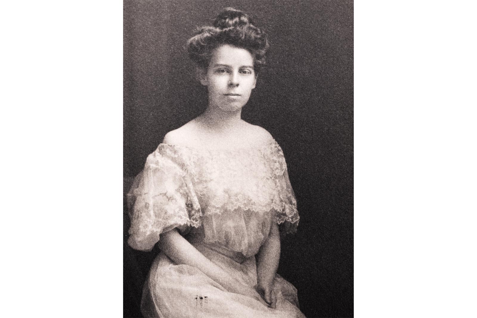
This undated photo is very likely a picture of Maude Motley taken around 1890, when she would have been in her late teens or early twenties. (Rochester Museum & Science Center)
Life at the Motley homestead was changing — the carefree days of the Chronicle were becoming more distant with each passing year. Lily in 1889 married banker Albert Fenn. The 1892 New York state census tallied the remaining occupants of 96 Lake Avenue: Ann, now fifty-six; George, twenty-three; Nellie, twenty-one; Maude, nineteen; Albert, fourteen; and domestic servant Louisa Kaltie, a twenty-year-old immigrant from Germany.35
Maude’s journal from these years documents a busy schedule of charity events, garden parties and country-club luncheons. She enjoyed cycling, alone or with friends, in nearby Seneca Park. Summers were spent with her sisters and their families at Kennebunk, Maine, where Alice had purchased a beachfront cottage.
She was in her mid-twenties, an age when most women would have been contemplating married life. But while it is difficult to detect any sign of a suiter among the pages of her journal, her lack of interest is readily apparent. “Invited to the University Junior Prom,” she jotted in February 1896. “But decided not to go.”36
Instead, Maude devoted her attention to subjects that must have seemed more important. She attended classes in art and architecture taught by Mrs. E. H. Hall, art committee chair for the local chapter of the Women’s Educational and Industrial Union, and a course on Greek sculpture at the Brick Church Institute.
She began a lifelong love affair with music and theater. Rochester did not yet have a professional symphony or opera company, so she made do. She attended “musicales” — informal gatherings in private homes that featured presentations and recitals — and patronized touring productions at the Lyceum Theatre. For serious theater, there were annual trips to Boston, Philadelphia, London (in 1894), and, especially, New York City.
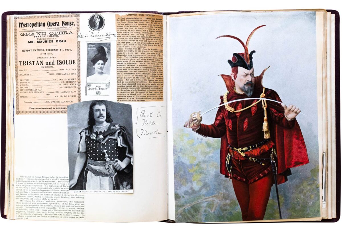
Maude Motley was an avid theatergoer for much of her life. From 1891 to 1916 she documented hundreds of performances that she attended in a scrapbook titled “The Players.” The Metropolitan Opera in New York City was a favorite venue: These pages include clippings and photographs from the February 11, 1901, performance of Wagner’s “Tristan und Isolde,” with Jean de Reszke and Lillian Nordica in the title roles, and a large color photograph of Edouard de Reszke as Méphistophélès in Charles Gounod’s “Faust,” performed at the Met a few days later. (Maude Motley, “The Players” [scrapbook], from the collection of the Rochester Public Library Local History & Genealogy Division)
A 10-day trip to New York in January 1900 with her friend Ella Thayer may have been typical. Chaperoned by Ella’s father, Rochester banker George W. Thayer, the two women stayed at the Waldorf Astoria, sightseeing during the day and attending theater and opera performances nearly every evening: Emma Calvé in Carmen and Lillian Nordica in Die Walküre at the Metropolitan Opera; The Maneuvers of Jane at Daly’s Theatre and Wheels Within Wheels at Hoyt’s. The highlight: Ben-Hur at the Broadway Theatre, a 3½-hour spectacle in which the story’s iconic chariot race was staged on treadmills with real horses. “To-night — Ben-Hur!” reads the scrawled entry in her journal. “A great day.”37
Yet reading may have been more important to Maude than anything else. She read constantly. References to books are sprinkled throughout her journal. Visits to Reynold’s Library are mentioned. Many times she just writes: “Staid at home. Read and sewed.”
“A fine day,” she wrote in March 1899. “Read Kipling to-night.” April 1900: “Am reading Balzac.” Later that year: “Read Plutarch’s Lives. Very high mind.”
She read novels by James Lane Allen (The Rule of Law), William Makepeace Thackeray (The Virginians), and Mrs. Humphrey Ward (possibly Helbeck of Bannisdale, though she doesn’t say).
The nonfiction books that she read reveal a curious and wide-ranging mind. George Iles’s Flame, Electricity and the Camera opens with a series of plates demonstrating three-color process printing and ends with an appendix titled “The Golden Age of Science.” Chapters include “The Higher Teachings of Fire,” “Multiplex Telegraphy,” and “Photography and Electricity as Allies.”
She read John Fiske’s two-volume history The Discovery of America as well as his ruminations on pantheism in The Idea of God as Affected by Modern Knowledge.
Leader Scott’s The Cathedral Builders: The Story of a Great Masonic Guild argues that the Comacine Masters, an obscure guild that arose in northern Italy after the fall of the Roman Empire, preserved the empire’s architectural traditions during the Middle Ages and propagated them throughout Western Europe. Leader Scott was the pen name of Lucy Emily Baxter, a British expatriate who lived in Florence, Italy. The thoroughness of her investigations into medieval history, art, and technology — and the lucid prose she employed in explaining them — may have given Maude an important role model that she could turn to later.
Turn, turn
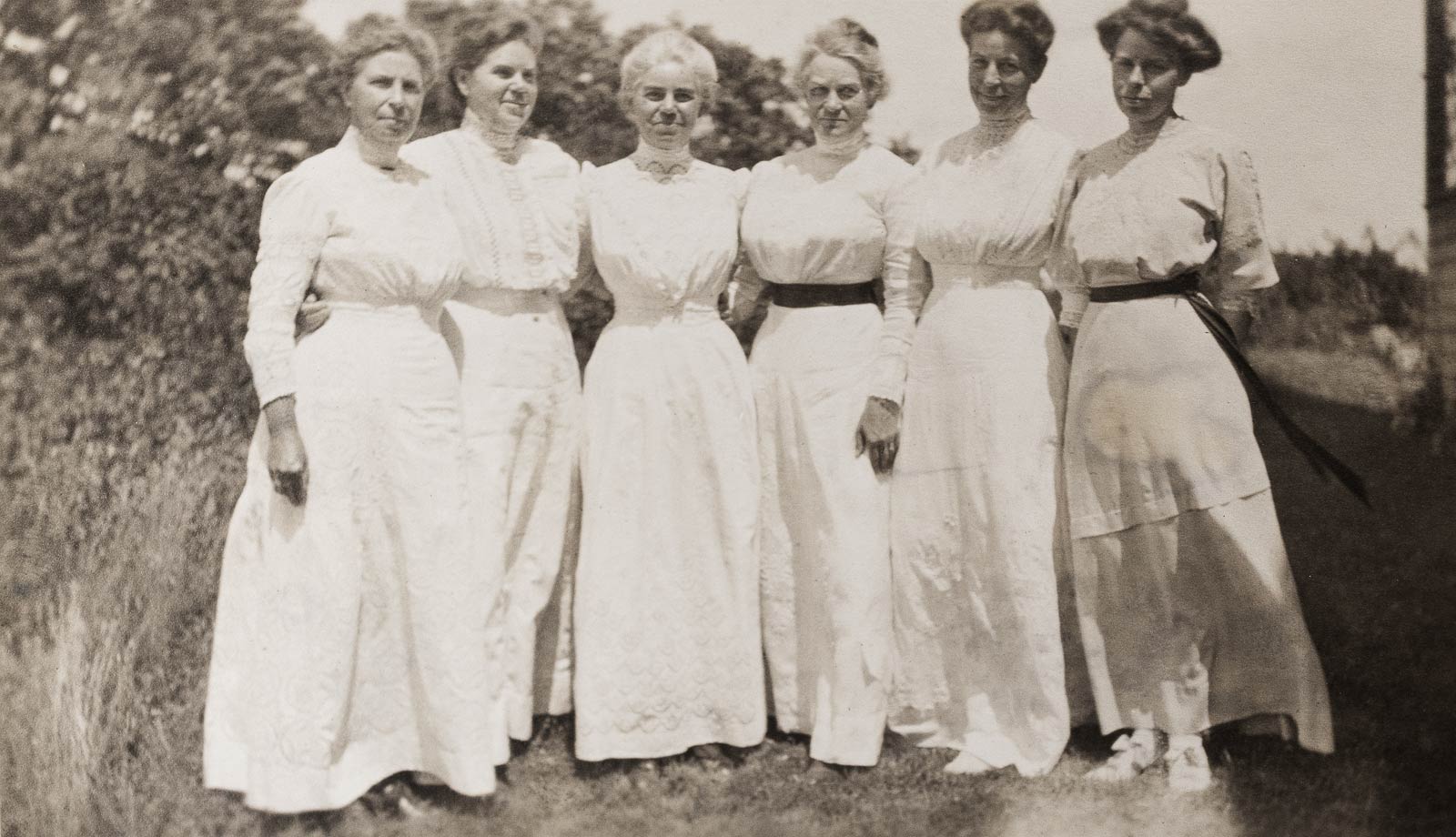
The six Motley sisters at Kennebunk Beach, Maine, sometime around the turn of the century. From left: Ida, Alice, Addie, Lily, Nellie, and Maude. The picture was taken by Alice’s daughter, Margaret Woodbury Strong. (Rochester Museum & Science Center)
In 1893 Nellie married businessman Albert B. Eastwood; four years later George married Mary Bater Farley. The big brick homestead on Lake Avenue was emptying out. Addie had moved back, though, and the 1900 census includes her along with Ann, Maude, Albert, twenty-three-year-old Irish servant Ellen Collins, and a forty-five-year-old schoolteacher named Jennie Brown.38 Ann had begun to rent out spare rooms, perhaps to help cover expenses.39
The house soon would be emptier: In December 1905 Ann Haughton Motley died at the age of sixty-seven. Years before in the “Chronicle of the Motley Family” Alice had written: “She is the Mother, and I don’t think can be matched by anyone, unless a possible exception in the case of Aunt Nelly.”40 Now she was gone.
Ann’s extended family had become part of the fabric of Rochester. As secretary and manager of the Moseley & Motley Milling Company, Charles Angle ran the business and, in 1897, was elected president of the Chamber of Commerce.41 George and Albert Motley worked in sales.42 Charles, Albert Fenn, and John C. Woodbury were on the board of the Alliance Bank.43 Albert Eastwood ran a shoe company with his father.44 The women continued their charity work and kept the social life of the family on track.
Meanwhile, the millstones of Rochester continued to turn. In January 1902 the Democrat and Chronicle estimated that the city’s annual flour output had peaked a few years earlier at about 1.3 million barrels; by 1901 mill closings had reduced this to 870,000 barrels, of which more than a third was manufactured by Moseley & Motley.45 Impressive as this sounds, Rochester’s flour output was but a fraction of that produced in the midwest. Mills in Minneapolis, alone, were grinding out 400,000 barrels per week, with total output for 1901 approaching 16 million barrels.46
Market pressure along with wheat rationing and government controls introduced during World War I would take a toll. So too the economic downturn in Europe after the war, which would depress flour exports. One by one, Rochester’s remaining mills would close. By 1925 only five would remain and annual production would fall to 100,000 barrels.47 The writing was on the wall.
The war
Within days of the United States’ declaration of war in April 1917 the Rochester Federation of Women’s Clubs began offering classes and enrolling volunteers for service work.48
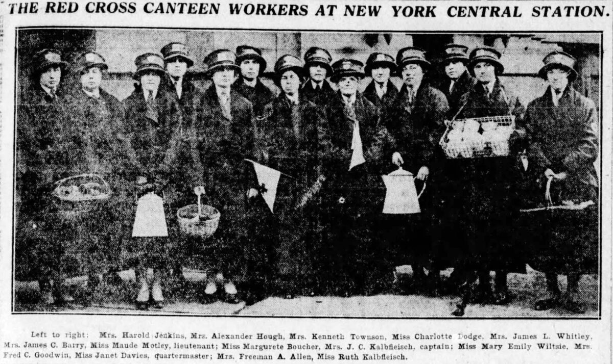
Maude volunteered to work at the Red Cross canteen at the New York Central railroad station downtown, handing out hot coffee, lunches, cigarettes, postcards and other amenities to troops passing through on their way to the front and, after the Armistice, returning home.49
Lieutenant Maude Motley, center, stands with other Red Cross Canteen volunteer workers at Rochester’s New York Central Station in this photograph, published January 30, 1919, in the Rochester Democrat and Chronicle. They are wearing uniforms based on those used by the Red Cross Motor Corps. (Newspapers.com, https://www.newspapers.com/image/135386066)
Her most direct connection to the conflict might have been through the military service of Harold Motley Kingston, a relative on her mother’s side of the family. Harold had joined the National Guard as a cavalryman in 1916 and was called to service in the regular army the next year. Through it all he faithfully wrote to his older cousin, whom he sometimes addressed as “Aunt Maude.” He signed his letters with a nickname, “Jim.”
Writing from Fort Sill, Oklahoma, on October 22, 1918, “Jim” described the effects of the flu epidemic and his increasing impatience to get to the front. “We are not allowed to leave our quarters because of the Spanish flu. They have taken every precaution here against the officers catching it, and we have had very few deaths. . . . I have been assigned to the 59th Field Artillery, but I am going to make a strong break for the new Cavalry regiments that are expected to go overseas after the first of the year. Cavalry for me every time. I can’t see this wagon soldier stuff at all. My kingdom for one good cavalry charge.”50
The war ended three weeks later. Instead of heading to France and “one good cavalry charge,” Harold was sent to Central America to guard the recently completed Panama Canal.
“A Living Church”
By 1920 Addie and Maude were all that remained of the Motley family residing in the original residence on Lake Avenue. Even though they continued to rent out the extra rooms, the house had become too large for the two of them.
Their sister Lily had continued to live at 57 Ambrose Street, a block away, after her husband Albert Fenn passed away in 1910. In August 1920 Lily died, leaving the house vacant. Addie and Maude were nothing if not practical. Lily’s home was the perfect size. They moved in the following year.51
There they would live, two single middle-aged women of independent means. Domestic servants took care of the household chores. Addie eventually would get a driver’s license and a Packard sedan.52 For her part Maude seems to have carefully invested her burgeoning inheritance while spending her extra money mostly on two things.
The first was books. Rare and collectible books were purchased from the Brick Row Book Shop on East 47th Street in New York City. A statement from April 1924 lists works by the Romantic poets, a 1785 first edition (“very scarce”) of The Poetical Works of Samuel Johnson, and James Boswell’s two-volume Life of Samuel Johnson (another first edition, “in old calf”).53 Ordinary books were acquired locally at Scrantom’s. A September 1924 invoice lists forty purchases from the previous month, including Shelley and the Romantics, Story of the Volsungs and Nibelungs, Lord Jim, Shakespeare’s England, and volumes on English, French, and German bookplates.54
Maude Motley’s personal bookplate, created by engraver Robert Eunson, who also designed a bookplate for Maude’s sister Alice Motley Woodbury. (Maude Motley, “The Players” [scrapbook], from the collection of the Rochester Public Library Local History & Genealogy Division)
The last three are evidence of the second thing Maude spent her money on: bookplates. For most people these old labels, displaying the owners’ names and glued to the inside covers of books, hardly warranted a second glance. But the designs often included illustrations by master engravers, and Maude, recognizing them as fine art, began to amass a large collection.
Her chief interests continued to be history, architecture, music and, of course, her church. That year they all would come into play with the publication of A Living Church: The First Hundred Years of the Brick Church in Rochester. As co-editor her name and title, “Chairman of the Historical Committee,” are prominently displayed on the book’s title page; a second title, chair of the Committee on Historical Papers, is listed by her name in the appendix. She would have had free access to the church’s records — a trove of primary documents extending back to 1825 — as she helped to organize and edit the book. Much of it would have been written by co-editor and assistant pastor Gerard B. F. Hallock and other contributors. But there are places where Maude’s voice can be heard: the character sketches of Hallock and other church leaders; the historical chapter, “Beginnings”; and the architectural chapter, “Buildings,” contributed by another writer but “amplified” by the editors.55
Centennial
Another much bigger anniversary was coming down the pike: the centennial of Rochester’s 1834 incorporation. Ambitious plans, somewhat dampened by the Great Depression, were being made. The Rochester Historical Society would do its part by publishing a four-volume series titled the Centennial History of Rochester, New York. The books, to be edited by City Historian Edward R. Foreman, would be issued annually beginning in 1931.
Founded in the 1880s, the Rochester Historical Society by 1922 had amassed a large collection of documents and artifacts. That year it began to publish papers drawn from this collection in an annual series of books, paid for by members who contributed to a special fund. Among the donors were Maude’s sister Ida Motley Angle, her brother-in-law Albert B. Eastwood, and Maude herself.56
The projected Centennial History would be integrated into this Publication Fund Series. But unlike previous installments it would not consist of existing papers and lectures. Instead, as Foreman wrote in the forward to the first volume, it would be filled with fresh material: “These books will be the composite work of men and women of special knowledge . . . being qualified by education, training and experience, to speak with authority upon the subject discussed.”
Foreman himself wrote much of Volume 1, including chapters on “French Penetration of the Genesee Country” and “Crown Grants and Early Land Claims Affecting the Rochester Region.”57
Other contributors included Arthur C. Parker, director of the Rochester Museum of Arts and Sciences; Herman LeRoy Fairchild, professor emeritus of geology at the University of Rochester; Arthur E. Sutherland, former justice of the New York State Supreme Court; United States meteorologist Jesse L. Vanderpool; and Nathaniel S. Olds, an authority on city and regional planning as well as on the history of western New York.
These men wrote about early exploration and settlement, treaties and land grants, and the region’s physical terrain and climate. But Rochester’s flour milling industry also was an essential part of the story, and it couldn’t be put off. The first volume would be titled Beginnings. It belonged there.
But who would write it?
“The Romance of Milling”
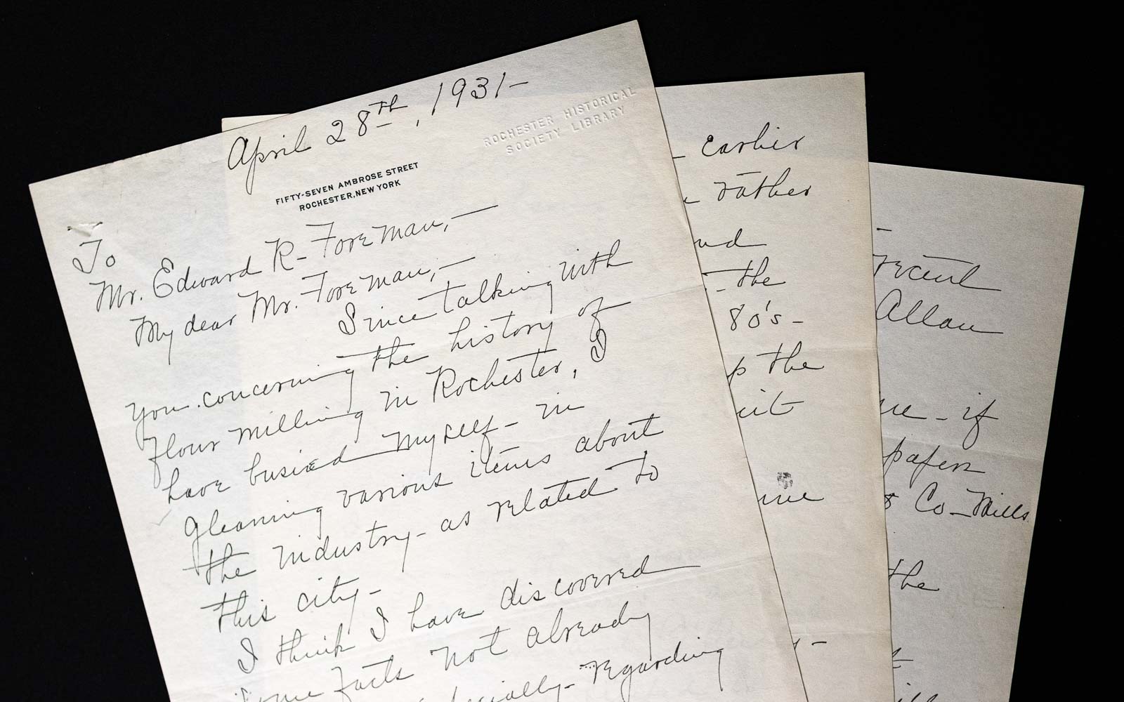
In an April 28, 1931, letter to City Historian Edward R. Foreman, Maude Motley continued an earlier discussion “concerning the history of flour milling in Rochester.” By mid-May she would begin writing her essay for the first volume of the Centennial History of Rochester, New York. (Rochester Historical Society)
Along with its collections and publication work, the historical society had long functioned as a social club. Maude and other members all moved in the same circles. She and Foreman no doubt were acquainted, and given her interest it should come as no surprise that they already had had conversations about flour milling by the time she wrote to him in April 1931.
“My dear Mr. Foreman,” she began. “Since talking with you concerning the history of flour milling in Rochester, I have busied myself in gleaning various items about the industry, as related to this city. I think I have discovered some facts not already covered — especially regarding the middle periods.”
“My idea would be to write a unified article touching lightly on the earlier epochs, these having been rather well taken care of — and treating more specifically the decades ’60s, ’70s and ’80s. Then, you could re-vamp the whole thing, later, to suit your requirements.”
She inquired about historical documents and closed with a question: “Can you give me a hint as to when this article will be wanted?”58
The book was scheduled to go on press before the end of the year. Foreman’s answer would have been something along the lines of: Immediately, if not sooner.
No further correspondence between Maude and Foreman has come to light, so we don’t know if her suggestion — that Foreman “re-vamp the whole thing later” — ever came to fruition. Given the compressed time frame and Foreman’s many responsibilities, it seems unlikely that he would have written (or rewritten) more than a brief passage here or there.
However that may be, the chapter’s title would be pure Maude Motley.
The phrase “the romance of milling” had already shown up a few times in print. It had been used as the title of a 1907 article in The Canadian Magazine.59 But a recent appearance on the front page of National Miller may have been the one that caught her eye.
“No matter what shifts in the marts of trade commerce compels, to Minneapolis goes the distinction of being the seat of the industry in this country,” pontificated the author, I. E. Diffenderfer. “Minneapolis will always be regarded by millers here as Rome was regarded by all Romans, and as Pittsburgh is regarded by all iron and steel men. It will represent much of the romance of milling, and much of the achievement in milling, and finally, it will represent the pioneer spirit that was the guiding force in the development of milling as an industry.”60
To Maude, these would have been fighting words. Diffenderfer and National Miller had dismissed the achievements of her beloved city — “the greatest milling center of the world” — without so much as a nod. Perhaps she saw her essay as a way to set the record straight: “The Romance of Milling: With Rochester the Flour City.”
“All hands Motleying”
Maude met with Foreman at the city historian’s office on the morning of Monday, May 11, to discuss her proposed chapter on milling.61
The office was in Edgerton Park, just a few blocks from Maude’s home. Besides Foreman, it employed a staff of three: James M. Angle, editor and, at age eighty-two a living, breathing encyclopedia of local history; and stenographers Annie H. Croughton, a sixty-one-year-old English immigrant, and Elizabeth V. Hill, who was in her early thirties. Most of the work of compiling, editing, proofreading, and indexing the first volume of The Centennial History of Rochester would rest upon their collective shoulders.
In regards to Maude, the most pressing tasks were to copy primary documents and help with additional research. They wasted no time. The office diary for the next day, May 12, includes the large, scrawled entry: “All hands on Mills.”62
Over the following weeks the diary entries continue: “Mills — Research”; “Miss Motley in re: information on milling — took autograph letter folders and typewritten sheets”; “Finished and took Miss Motley ms. on milling. A. H. C.” All the while the staff worked on inventories and other publications, shelved books, and handled the myriad other tasks that constituted the daily business of an historian’s office. (“Someone lost Vol. VIII from library [on] Hudson Ave.,” runs one rather plaintive diary entry. “Called to know how much another would cost $5.00.”)63
Maude’s initial drafts began to arrive by mid-June. They were probably written in longhand and would need to be typed up. The typescript would then be compared to the original, edited, and corrected.
The work went on through the summer’s sweltering heat, which peaked at 99 degrees on July 2. Maude continued to drop off sections as she completed them. By the end of that month — less than twelve weeks since that May 11 meeting — she submitted the last part.64
Meanwhile the contract had been signed with local printer Canfield & Tack. Parts of the book were already being set into type. The office staff now would be juggling those galley proofs as they edited, fact-checked, and corrected Maude’s manuscript, which had grown to be, by far, the longest chapter in the book. As August and September wore on it was corrected, copied, and compared again.
Deadlines were pressing and Foreman’s overworked staff was getting a little punch-drunk.
The diary entry for Monday, September 28, reads: “All hands staggering on, wearing Motley and fools-bells.”
For Tuesday, September 29: “All hands Motleying.”
Finally, for Friday, October 2, in giant, red letters: “MOTLEY MOVES to Canfield.”65
Typesetting, proofreading, and indexing the book occupied the office through the middle of March. The first advance copies were delivered on April 2, 1932.
Unbound copies had already been provided to local newspapers, and initial reviews were glowing. The Rochester Democrat and Chronicle declared that the book, which included “65 illustrations and maps” was “as interesting as it was informative.”
The newspaper noted that “Miss Motley’s ‘Romance of Milling,’ is a carefully authenticated history of the milling industry of Rochester, but it is much more than that for she has searched old records for colorful details and incidents which make the early life of the city vividly real.”66
Endings
The Democrat and Chronicle’s brief assessment of Maude’s essay still holds up more than ninety years later. She had read the standard histories of Rochester beforehand, and as she wrote she had the city’s most knowledgeable historians and many important primary documents at her disposal. It is carefully authenticated, and it does make the early life of the city vividly real — not all of it, just those parts related to the milling industry.
“The Romance of Milling” isn’t perfect. Maude was an unabashed community booster who wanted to please her audience, which could lead her to wander off on tangents every now and then. And there are a few factual errors, which is not surprising given the pace at which the chapter was researched, written and edited. But at ninety-one pages it is the length of a short book, and each page is packed with information.
Maude Motley, photographed later in life with Armenia Sprague Kingston, widow of Maude’s cousin George W. Kingston. (Courtesy of James Pendleton)
Nine months after the publication of “The Romance of Milling: With Rochester the Flour City,” Maude Motley’s health failed. After an illness of two weeks she died at home, as her father had, of heart failure. The date was January 5, 1933; she was sixty years old.67
Funeral services were held two days later at her home on Ambrose Street. Burial followed at Rochester’s Mount Hope Cemetery, where she was laid to rest next to her parents and little Jessie.
Edward R. Foreman appended an appreciation to the second volume of the Centennial History, then nearing completion: “Maude Motley will be remembered best as a friend. . . . She left a legacy of good will. During her happy life on earth, she gave kindly greetings to all. She was a genial, cultivated woman, interested in everything about her, always willing to lend a helping hand, and vital in her enjoyment of the great gift of living. . . . She was a citizen of Sunshine Country, whose death makes the world less bright, seen through tear-dimmed eyes.”68
Maude’s estate was valued at $251,992, the bulk of which was invested in bonds and stocks, including nine shares of stock in Moseley & Motley Milling Company worth $9,000. Personal property included “old jewelry of no appreciable value” and a “library of modern and rare books” (which may have included Maude’s bookplate collection) worth $3,100.69
After bequests of $5,000 each to sisters Alice Motley Woodbury and Eleanor Motley Eastwood, and $3,000 each to four nieces and nephews, the balance of the estate after taxes, some $225,000, was left to sister Addie Motley Webster.70
The Motley homestead on Lake Avenue remained in the family as a rental property until Addie, the last surviving sibling, died in 1938. It was then sold and in 1960 demolished to make way for a service station.71 Today the property is occupied by a U-Haul rental office.
Increased competition, aging equipment, and declining sales led the board of the Moseley & Motley Milling Company to sell out in the summer of 1935. The announcement was made on July 10 by company President Wesley M. Angle, grandson of George and Ann Haughton Motley. The mills ran until the following February, when the business closed its doors for good. It was the last mill to shutter at Brown’s Race, and its departure left but one, the VanVechten Mill on Smith Street, operating in the city of Rochester.72
Back of the flour
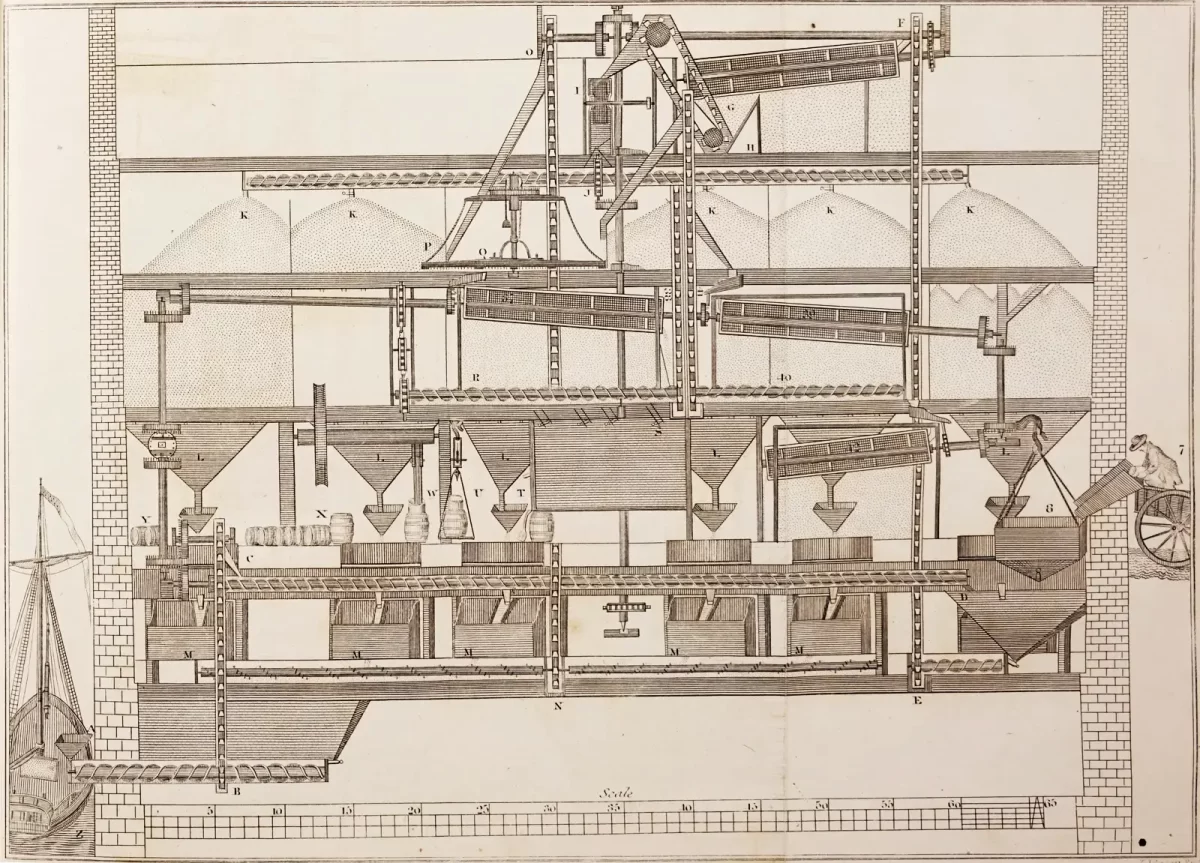
While “The Romance of Milling” is concerned, start to finish, with the business of flour milling, Maude Motley held off on describing the process itself until the very end. She then wrote what may be the chapter’s most eloquent passage. As published, it is a single paragraph. Here, it is divided into four shorter paragraphs — stanzas, if you will — to encourage you to read it in its entirety:
“Nature produced the wheat fields, stored with life-giving energy, and the material that makes brain and muscle. Wheat, however, would avail little had not the mind of man conceived methods to convert the grain into flour. From the golden harvest fields the wheat flows along the arteries of travel, until it reaches the mill, humming with busy machinery grinding thousands of bushels of wheat, and ever eager to receive more.
“The machinery is self-sufficient. No human hand will touch the wheat in its journey through the mill. Endless belts carrying steel buckets convey the grain to the cleaning department, where marvelously devised machines separate all foreign substances from the wheat, such as oats, cockle or corn. The pure wheat is then carried to the scouring machine, where it is thoroughly scoured and brushed.
“Steadfastly the wheat pursues its way to the accompaniment of louder roaring of belts and wheels, which proclaim the mighty rolls. Here the wheat berry is broken open, and from its center, the heart, the choicest part, is extracted and sent on to the grading machines. These centers are then sent to the purifiers, where fans drive out all fiber and fluff. Fascinating to observe are these purifiers through which the wheat centers sift gradually through exquisite silken cloths, like softly falling snow.
“Fine and white it seems already, but the process of purification is not yet complete. The selected uniform centers pass on to the smoothing rolls where they are gradually pulverized into flour. Thence to the reels to be bolted through silk cloths into creamy white flour. Then it proceeds to the packers, where it is packed by machines into sacks and barrels. In the process several lower grades of flour are made, but only the choicest portions of the hard spring wheat are used to produce the high grade patents, so much desired by the trade.”73
Maude, who loved poetry, quoted two poems as she brought her long chapter to a close. One, written by “poet laureate of the Genesee” Thomas Thackaray Swinburn, comes at the very end. The other appears earlier and is much briefer. Its author, whose name she does not mention, was Maltbie Davenport Babcock, a Presbyterian clergyman who had ministered at churches in Baltimore and New York City. His poem, published posthumously in 1901, was later set to music and repurposed as a hymn.74
In hindsight, given Maude’s faith and appreciation for the life-giving qualities of wheat, flour, and bread, Babcock’s verse may have made the better ending.
Back of the loaf is the snowy flour, And back of the flour the mill; And back of the mill is the wheat, and the shower, And the sun, and the Father’s will.75
Maude Motley, “The Romance of Milling: With Rochester the Flour City,” in Edward R. Foreman, editor, Centennial History of Rochester, New York, vol. 1, Beginnings (Rochester, New York: Rochester Historical Society, 1931), 141. Emphasis in original. ↩︎
Maude Motley, The Motley Family in Rochester, N.Y., typescript, n.d.; file People — Motley; Rochester Historical Society, Rochester, New York. “England Births and Christenings, 1538-1975,” database, FamilySearch (https://www.familysearch.org/ark:/61903/1:1:JQPW-T82 : accessed 22 June 2024), George Motley, christening, Covenham St. Mary, Lincolnshire, 28 September 1834. Covenham St. Mary is a neighboring parish of Covenham St. Bartholomew. ↩︎
1841 Census of England, Lincolnshire, Wapentake of Ludborough, Parish of Covenham St. Bartholomew, Louth registration district, Tetney sub-registration district, Enumeration Districts 13 and 14 (part), folio 7, p. 10, lines 3–7, George Motley household; “1841 England Census,” database with images, Ancestry (https://www.ancestry.com/discoveryui-content/view/6728325:8978 : accessed 21 June 2024); citing The National Archives of the UK, HO 107, piece 631, book 15. Ages in the 1841 English census were rounded down to the nearest five years for those fifteen and over: https://www.genuki.org.uk/big/eng/LIN/census. ↩︎
Wesley M. Angle, “The Moseley & Motley Milling Co.,” Genesee Valley Scrapbook 2, no. 1 (1951): 18. ↩︎
“More Shipwrecks! Loss of the Packet-ship Black Hawk,” New-York Daily Times, 18 May 1854, p. 1, cols. 4–5; image copy, Newspapers.com (https://www.newspapers.com/image/20464333 : accessed 15 June 2024). “The American Ship Black Hawk,” The (London) Daily News, 5 May 1854, p. 6, col. 2: image copy, Newspapers.com (https://www.newspapers.com/image/390786734 : accessed 15 June 2024). Sadly, three rescued infants did not survive the return voyage to England. ↩︎
“The American Ship Black Hawk,” p. 6, col. 2. The list of passengers rescued by the Caroline includes “George Mattley, Great Grimsby [Lincolnshire].” ↩︎
“Gales, Disasters, &c.,” Shipping and Commercial List, and New-York Price Current, 4 October 1854, p. 1, col. 8; image copy, Readex: America’s Historical Newspapers (access through participating libraries: accessed 15 June 2024). District of New York–Port of New York, List or Manifest of Passengers, Ship Andrew Foster from Liverpool, 2 October 1854, passenger no. 179, George Motley; “New York, U.S., Arriving Passenger and Crew Lists (including Castle Garden and Ellis Island), 1820-1957,” database with images, Ancestry (https://www.ancestry.com/discoveryui-content/view/1795335:7488 : accessed 15 June 2024) > image 4; citing Passenger Lists of Vessels Arriving at New York, New York, 1820-1897, microfilm publication M237 (Washington, DC: National Archives and Records Administration, n.d.), 675 rolls, roll not specified. ↩︎
Wesley M. Angle, “The Moseley & Motley Milling Co.,” 19. “Register of Marriages in and for the County of Hastings,” George Motley–Ann Jane Houghton, 4 March 1857, p. 168, line 2; “Ontario, Canada, Marriages, 1826–1939,” database with images, Ancestry (https://www.ancestry.com/discoveryui-content/view/3837116:7921 : accessed 15 June 2024) > image 5; citing District Marriage Registers, 1801–1858, microfilm publication MS248 (Toronto, Canada: Archives of Ontario, n.d.), Reel 4. ↩︎
Wesley M. Angle,”The Moseley & Motley Milling Co.,” 19. ↩︎
A Directory for the Village of Rochester (Rochester, New York: Elisha Ely, 1827), 115, “Statistics”; image copy, HathiTrust (https://hdl.handle.net/2027/hvd.hn4grz : accessed 15 June 2024 ) > image 123. ↩︎
A Directory for the Village of Rochester, 119–120, “Miscellaneous Manufacturies”; image copy, HathiTrust (https://hdl.handle.net/2027/hvd.hn4grz : accessed 15 June 2024) > images 127–128. ↩︎
Neal Adams McNall, An Agricultural History of the Genesee Valley, 1790–1860 (Philadelphia: University of Pennsylvania Press, 1952), 148. ↩︎
Wesley M. Angle, “The Moseley & Motley Milling Co.,” 19. ↩︎
“Patent Public Search Basic,” USPTO: United States Patent and Trademark Office, database with images, (https://ppubs.uspto.gov/pubwebapp/static/pages/ppubsbasic.html : accessed 15 June 2024), images, George Motley, “Improvement in Making Flour,” patent file no. 113,079 (1871); original file location not cited. ↩︎
Wesley M. Angle, “The Moseley & Motley Milling Co.,” 19. ↩︎
“Chronicle of the Motley Family with Its Branches,” 1, entry by Addie Motley Webster; file Unidentified 3, box Motley Family Photos & Documents; Rochester Museum & Science Center, Rochester, New York. ↩︎
Maude Motley, “The Romance of Milling,” p. 213. The Rochester Directory (Rochester, New York: Drew, Allis, 1884), pp. 83, 528, Charles E. Angle and Edward A. Webster; image copy, Rochester Public Library (https://www.libraryweb.org/rochcitydir/images/1884/1884complete.pdf : accessed 16 June 2024). ↩︎
G. B. F. (Gerard Benjamin Fleet) Hallock and Maude Motley, editors, A Living Church: The First Hundred Years of the Brick Church in Rochester (Rochester, New York: Henry Conolly, 1925), 242; image copy, HathiTrust (https://hdl.handle.net/2027/wu.89072990096) > image 300. Known today as the Downtown United Presbyterian Church, this historic building (destroyed by fire and rebuilt in 1903) remains a Rochester landmark. ↩︎
Maude Motley, “The Romance of Milling,” 212. “Chronicle of the Motley Family,” 8, entry by Lily Motley, 10 January 1885. ↩︎
“Chronicle of the Motley Family,” 8, entry by Lily Motley, 10 January 1885. ↩︎
The Ægis (Rochester, New York: Rochester Free Academy, 1891), pp. 98, 112, 127, 128, 140, Alice Mary Motley, Addie Minnie Motley, Nellie Haughton Motley, Ida Motley, George Motley; image copy, Rochester Public Library (https://www.libraryweb.org/~digitized/yearbooks/Roch_Free_Academy/1891.pdf : accessed 15 June 2024). “Chronicle of the Motley Family,” 6, entry by Lily Motley, 7 January 1885. ↩︎
“Chronicle of the Motley Family,” 11, entry by Alice Motley Woodbury, 12 January 1885. ↩︎
Ibid., 41–42, entry by Alice Motley Woodbury, 25 March 1885. ↩︎
Ibid., 2, entry by Addie Motley Webster, 1 January 1885. ↩︎
“The Finest Rink in the City,” (Rochester, New York) Democrat and Chronicle, 13 September 1884, p. 7, col. 4; image copy, Newspapers.com (https://www.newspapers.com/image/135089973 : accessed 16 June 2024). ↩︎
“Wallace v. Vacuum Oil Company,” New York State Supreme Court, 24 January 1891, The New York Supplement: Containing the Decisions of the Intermediate and Lower Courts of Record of New York State, Permanent Edition, Volume 12, January 22–March 19, 1891 (St. Paul: West Publishing, 1891), 426; image copy, HathiTrust (https://hdl.handle.net/2027/umn.31951t00001842m : accessed 16 June 2024) > image 444. ↩︎
“Naphtha! Terrible Explosion Which Destroys Three Mills,” (Rochester, New York) Democrat and Chronicle, 22 December 1887, pp. 6–7; image copy, Newspapers.com (https://www.newspapers.com/image/135103020 : accessed 16 June 2024). ↩︎
“Flames at Last Subdued,” (Rochester, New York) Democrat and Chronicle, 23 December 1887, p. 6, cols. 5–6; image copy, Newspapers.com (https://www.newspapers.com/image/135103084 : accessed 18 June 2024). ↩︎
1892 New York State Census, First Election District, Ninth Ward, Rochester, Monroe County, unpaginated, 19th page, line 21, Ann J. Motley household; “New York State Census, 1892,” database with images, FamilySearch (https://www.familysearch.org/ark:/61903/3:1:S3HT-DRJ3-SQG : accessed 16 June 2024) > image 11; citing “county offices, New York.” ↩︎
Maude Motley, “A Line a Day” journal, 1896–1900, unpaginated, entry for 18 February 1896; folder 10, box 132, Subseries B, Series VI, Margaret Woodbury Strong Collection; The Strong National Museum of Play, Rochester, New York. ↩︎
Maude Motley, “A Line a Day” journal, entry for 18 January 1900. ↩︎
1900 U.S. Census, Monroe County, New York, population schedule, enumeration district (ED) 65, sheet 1-A, house no. 8, family no. 9, Ann J. Motley household; “United States Census, 1900,” database with images, FamilySearch (https://www.familysearch.org/ark:/61903/3:1:S3HT-6SDS-FBG : accessed 16 June 2024) > image 1; citing NARA microfilm publication T623, roll not specified. ↩︎
“To let — Very desirable furnished front and side rooms,” classified advertisement, (Rochester, New York) Democrat and Chronicle, 11 March 1902, p. 5, col. 6; image copy, Newspapers.com (https://www.newspapers.com/image/135279464/ : accessed 16 June 2024). ↩︎
“Chronicle of the Motley Family,” 48, entry by Alice Motley Woodbury, 8 April 1885. ↩︎
Wesley M. Angle, “The Moseley & Motley Milling Co.,” 20. “Annual Meeting of Chamber Commerce [sic],” (Rochester, New York) Democrat and Chronicle, 7 December 1897, p. 12, cols. 5–6; image copy, Newspapers.com (https://www.newspapers.com/image/135284244 : accessed 16 June 2024). ↩︎
Wesley M. Angle, “The Moseley & Motley Milling Co.,” 23. ↩︎
“Alliance Bank,” advertisement, (Rochester, New York) Democrat and Chronicle, 5 May 1900, p. 14, cols. 1–2; image copy, Newspapers.com (https://www.newspapers.com/image/135242722 : accessed 16 June 2024). ↩︎
“Boot and Shoe Company Incorporated,” (Rochester, New York) Democrat and Chronicle, 3 August 1899, p. 8, col. 4; image copy, Newspapers.com (https://www.newspapers.com/image/135231987 : accessed 29 June 2024. ↩︎
“The Flour Mills of Rochester,” (Rochester, New York) Democrat and Chronicle, 2 January 1902, p. 8, col. 7; image copy, Newspapers.com (https://www.newspapers.com/image/135248279 : accessed 16 June 2024). ↩︎
“Flour Milling in the Northwest,” The New York Times, 5 January 1902, p. 43, cols. 1–2; image copy, Newspapers.com (https://www.newspapers.com/image/20376207 : accessed 16 June 2024). “More ‘Waning’,” The Minneapolis Journal, 3 January 1902, p. 4, col. 2; image copy, (https://www.newspapers.com/image/76275453 : accessed 16 June 2024). ↩︎
“Women Enroll to Prepare for War-Time Work,” (Rochester, New York) Democrat and Chronicle, 13 April 1917, p. 22, col. 7; image copy, Newspapers.com (https://www.newspapers.com/image/135339603 : accessed 16 June 2024). ↩︎
“Canteen System Organized More Than a Year Ago,” (Rochester, New York) Democrat and Chronicle, 3 June 1918, p. 15, col. 4; image copy, Newspapers.com (https://www.newspapers.com/image/135359210 : accessed 16 June 2024). ↩︎
Harold Motley Kingston to Maude Motley, letter, 22 October 1918, privately held by James Pendleton, Marblehead, Massachusetts, 2024. This item was among a collection of letters passed from Maude Motley (1872–1933), Pendleton’s first cousin (three times removed), to her first cousin (once removed) Esther Kingston (1897–1989) to her daughter Susan H. Nottingham (1941–2009), from whom the current owner inherited it in 2017. ↩︎
Invoice no. 7820, The Brick Row Book Shop, 25 April 1924; folder 2, box 133, Subseries B, Series VI, Margaret Woodbury Strong Collection; The Strong National Museum of Play, Rochester, New York ↩︎
Statement of Account, Scrantom’s, 1 October 1924; folder 2, box 133, Subseries B, Series VI, Margaret Woodbury Strong Collection; The Strong National Museum of Play, Rochester, New York. ↩︎
Hallock, G. B. F. (Gerard Benjamin Fleet) and Maude Motley, editors, A Living Church: the First Hundred Years of the Brick Church In Rochester (Rochester, N.Y.: Henry Conolly, 1925); image copy, HathiTrust (https://hdl.handle.net/2027/wu.89072990096 : accessed 17 June 2024). ↩︎
“Publication Patrons of the Rochester Historical Society,” [in Edward R. Foreman, editor,] Publications of the Rochester Historical Society: Publication Fund Series, vol. 1 (Rochester, New York: Rochester Historical Society, 1922), unpaginated front matter; image copy, HathiTrust (https://hdl.handle.net/2027/njp.32101076898301 : accessed 25 June 2024) > images 7, 9, and 12. ↩︎
Confusingly, volumes 1–4 of The Centennial History of Rochester, New York are also volumes 10–13 of the Publication Fund Series. ↩︎
Maude Motley to Edward R. Foreman, letter, 18 April 1931; file Motley, Maude, box Me–Mot, Autograph Letters; Rochester Historical Society, Rochester, New York. ↩︎
Randolph Carlyle, “The Romance of Milling,” The Canadian Magazine (November 1907): 65–74; image copy, HathiTrust (https://hdl.handle.net/2027/hvd.32044100137678 : accessed 17 June 2024) > images 77–86. ↩︎
I. E. Diffenderfer, “This Sweet Humidity,” National Miller 29 (May 1924): 11–12, 64, specifically 11; image copy, HathiTrust (https://hdl.handle.net/2027/pst.000019090986 : accessed 17 June 2024) > images 431–432, 484. ↩︎
1931 office diary, p. 131, 11 May 1931; Office Diaries, People — Foreman, Edward R; Rochester Historical Society, Rochester, New York. ↩︎
Ibid., pp. 271, 272, 275, 28–29 September and 2 October 1931. ↩︎
“Growth of Rochester is Detailed in History to be Issued in April,” (Rochester, New York) Democrat and Chronicle, 26 March 1932, p. 15, cols. 2–3; image copy, Newspapers.com (https://www.newspapers.com/image/135406676 : accessed 17 June 2024). ↩︎
“Funeral Tomorrow for Maude Motley,” (Rochester, New York) Democrat and Chronicle, 6 January 1933, p. 16, col. 4; image copy, Newspapers.com (https://newspapers.com/image/135185493 : accessed 16 June 2024). Brick Church records give January 4 as the date of her death: “Names of Members: Brick Church,” Rochester, New York, 1832–1940, unpaginated ledger arranged alphabetically by last name, entry for Maude Motley; “U.S., Presbyterian Church Records, 1701–1970,” database with images, Ancestry (https://www.ancestry.com/discoveryui-content/view/1500376264:61048 : accessed 18 June 2024) > image 180; citing “Register_deaths_1832–1840,” accession no. V Mi46 R58914rm V.3, “US, Presbyterian Church Records, 1701–1907,” Presbyterian Historical Society, Philadelphia, Pennsylvania. ↩︎
Edward R. Foreman, “Historiettes,” in Centennial History of Rochester, New York, vol. 2, Home Builders (Rochester, New York: Rochester Historical Society, 1932), p. 339. ↩︎
Transfer Tax Deposition, 27 February 1933, Monroe County, New York, Surrogate’s Court, File 1933–843, Maude Motley Last Will and Testament and related documents, digital scan of microfilm copy; microfilm not cited. Adjusting for inflation, the total value of the estate would be more than $6 million in 2024. “CPI Inflation Calculator,” U.S. Bureau of Labor Statistics (https://www.bls.gov/data/inflation_calculator.htm, accessed 16 June 2024.) ↩︎
Transfer Tax Deposition, 27 February 1933, Monroe County, New York, Surrogate’s Court, File 1933–843, Maude Motley Last Will and Testament and related documents. ↩︎
“Flour Mills Sold, Old Industry Goes,” (Rochester, New York) Democrat and Chronicle, 11 July 1935, p. 17, col. 3; image copy, Newspapers.com (https://www.newspapers.com/image/135214185 : accessed 17 June 2024). ↩︎
“Give Us This Day Our Daily Bread” in Thoughts for Every-Day Living: From the Spoken and Written Words of Maltbie Davenport Babcock (New York: Charles Scribner’s Sons, 1901), 167; imaged at HathiTrust (https://hdl.handle.net/2027/ia.ark:/13960/t2697kf38 : accessed 15 June 2024) > image 195. Maude Motley may have encountered Babcock’s poem as a hymn during services at the Brick Church. Her version differs slightly from Babcock’s original, which is used here. ↩︎
The four-story Red Mill (center right) is prominently featured in this detail from a hand-drawn, early 19th-century map of Rochester. North is to the right. The Genesee River flows from left to right, with artificial mill races branching off either side to supply water power to several mills and factories. On the west side of the river (top), from left: the sawmill of John C. Rochester and Harvey Montgomery; and the sawmill and Red Mill of Ely & Co. On the east side, from left: Hervey Ely’s two sawmills; the clothworks; the paper mill built in 1818 by Derrick Sibley and Harvey Gilman; William Atkinson’s Yellow Mill, built in 1817; an unidentified mill; and William Johnson’s oil and woolen mills, built in 1818. The map’s origin and date are uncertain. The lack of any reference to the Erie Canal and aqueduct would seem to place it before the summer of 1821; however, the unidentified mill may be Hervey Ely’s Etna Mill, completed in 1822. (Rochester Historical Society)
The raising of the Red Mill was cause for celebration in the Hundred Acre Tract.
Finished in 1815, the four-story structure became the first gristmill on the tract since Ebenezer Allan’s failed effort twenty years before. Allan’s mill employed one pair of crudely carved millstones; the Red Mill’s large overshot wheel powered four.1 Supplied with grain harvested on the Genesee Flats and shipped north in Durham boats,2 it was intended to put Rochesterville on the map.
“It was the greatest thing that had been done for the locality and, for years, that mill continued to grind the ‘grists’ that crowded to its doors from far and near,” wrote Maude Motley, who would be born decades later into a prominent Rochester milling family. “It was not unusual for men waiting their turn for grinding to spend the whole night in that first red mill, beguiling the time by telling stories and drinking.”3
Four years earlier, the future had not seemed so bright.
In late 1811 the Hundred Acre Tract was nearly untouched wilderness. Near a shelf of natural rock by the Upper Falls, the pitiful remains of Allan’s mills lay crumbling into the earth. His sawmill had been swept away by a freshet in 1803 — a harbinger of things to come — and the gristmill had burned four years later.4
Nathaniel Rochester, then 59 years old, spent several weeks patiently laying out a city that for the moment existed only in his imagination. He then hired a neighbor, Enos Stone, as his agent and returned to his farm in Dansville. Stone purchased the first lot that November.5
More than anyone, Rochester understood the tract’s waterpower potential and wished to take advantage of it by building his own mill there. But he was broke.
“I have been to the Falls of Genesee lately, and laid out & sold some more lots, say about twenty-five in all,” he wrote that November to his brother-in-law. “And for want of funds to build a good Merchant Mill there, I have leased a Mill seat for ten years, which will contribute very much to the improvement of the Town & neighborhood.”6
Rochester did not specify who had taken the lease. But an earlier letter from his partner Charles Carroll offers a clue: “We have no hesitation in acceding to the offer of Genl. M’Clure & Mr. Cameron to erect a merchant mill on any part of our Estate.”7
“Genl. M’Clure & Mr. Cameron” likely would have been George McClure and Dugald Cameron of Bath, Steuben County. McClure, a miller and farmer, “also became the local postmaster, county judge, state legislator, and a brigadier general in command of the county militia.”8 Any plans he may have had for the Hundred Acre Tract would have been interrupted by the War of 1812; his part in that did not go well and ended with him shouldering much of the blame for the burning of Buffalo.
Ely & Co.
Meanwhile, the war had put a stranglehold on the Hundred Acre Tract. McClure’s contract having fallen through (if indeed there ever was one), Rochester and his partners were ready to find someone else who could build a gristmill, demonstrate the site’s potential, and kick its development into gear.
They had good reason to press ahead. Competing settlements at the Middle and Lower Falls — Hanford’s Landing and Franklin to the north, and Carthage to the northeast — threatened to siphon off settlers and surpass Rochesterville. At any moment Enos Stone, in Brighton on the opposite bank, might begin selling lots adjacent to the river that, after the construction of a raceway, could be used as mill seats.
Gristmills at the Genesee Falls would have used a system developed in the late 1780s by Oliver Evans of Newport, Delaware, who combined existing technology with machines of his own invention to grind, dry, sift, and pack finished flour into barrels — the first automated assembly line. The process, for which he received one of the nation’s first patents, dramatically reduced waste and the labor required to mill grain. In his book describing the new process, “The Young Mill-Wright & Miller’s Guide,” he calculated that it could save a mill operator $298 a year. “A mill that made 40 barrels a day, required four men and a boy,” he wrote. “Two men are now sufficient.” (Library of Congress.)
The appearance in 1813 of two brothers from West Springfield, Massachusetts, provided the catalyst that Rochester and his partners needed.
The Ely brothers — Elisha was 32, Hervey, 22 — arrived brimming with self-confidence and determination. They had practical experience in water-powered manufacturing: Elisha and his older half-brother, Alexander, had operated a wool-carding mill in Massachusetts.9 The Elys opened a store on Buffalo Street and erected a sawmill that would commence business the following spring.10 Then Elisha Ely applied for and received water rights for seven years on the primitive raceway and negotiated a lease for a lot on which to build a gristmill.11
The terms of the lease have not surfaced, but Rochester may have sweetened the deal by making it rent-free, at least initially.12 At any rate, the Elys and their partner Josiah Bissell Jr. proceeded to build their four-story mill and finished it with a coat of red paint.
Rochester, Fitzhugh, and Carroll remained steadfast in their commitment not to sell any mill seats in the Hundred Acre Tract. Not even to family: Nathaniel Rochester, whose son John C. Rochester and son-in-law Harvey Montgomery built a sawmill near the Red Mill, retained ownership of the property and required a lease for the mill.13
After building a store, a sawmill, and a gristmill in the Hundred Acre Tract, Ely & Co. hedged their bets in 1815 by purchasing two lots from Stone.14 They also leased a third lot that included a sawmill;15 two years later Hervey Ely would build a second, larger sawmill next to it.16 North of the sawmills stood a carding machine and woolen clothworks with a yard full of tenter bars on which the fulled cloth was stretched to dry.17
Stone’s efforts to develop his Brighton property had been haphazard. Contracts drawn up for the mill lots he sold included a section committing him to build a raceway to supply water to them. But he never got around to building it. William Atkinson used the lots he occupied to store lumber and barrels while he waited for the water that someday would power a mill.18
Advertising placed by Elisha Johnson in newspapers throughout the northeast United States, including the July 7, 1817, edition of the Rochester Telegraph, mentioned the water lots (mill lots) that were for sale and made special note of the canal (raceway) that he had built to supply water to them. (FultonHistory.com.)
“The capitalist and the man of enterprize”
So things stood until 1817, when Elisha Johnson arrived at the Genesee Falls.
A Yankee from Wells, Vermont, Johnson had relocated as a young man to western New York, where he found work as a surveyor.19 He had come to the Falls at the behest of the founders of Carthage, and for them Johnson laid out a classic New England town with a promenade along the edge of the gorge and a central square.20
When he was finished he may have looked south to Enos Stone’s farm and sensed an opportunity.
Exhibiting some skill as an entrepreneur as well as a surveyor, Johnson negotiated the purchase of Stone’s farm and a mortgage (financed by Stone) that would allow him to pay off its $10,000 price over ten years with no interest. The terms of the mortgage also required Johnson to build the millrace that Stone had for so long put off.21 Johnson then sold a fifty percent stake in his purchase to a group of Canandaigua investors. They agreed to pay Johnson $10,000 in several installments over five years with interest, and to pay half of his mortgage to Stone. The investors — Orson Seymour, Harris Seymour, and Punderson B. Underhill — also agreed to pay for half of the new raceway.22
Mortgaged to the hilt, Johnson did not stop there. He made a proper survey, laying down streets, town lots, mill seat lots, and a public square.23 (He later would have the resulting map professionally engraved and printed.) He opened a land office on his new Main Street and, to attract purchasers, placed ads in newspapers across the Northeast. When he boasted in the advertisement that “there is no village in the western country . . . which offers to the capitalist and the man of enterprize so many inducements for settlement, as Rochester,” he may have had himself in mind.24
He also began blasting a channel for the long-awaited raceway.
It was a massive and expensive undertaking. The dam and raceway — four feet deep, up to 60 feet wide, and a thousand feet long — would reportedly end up costing $12,000. By the end of the year the raceway extended to lot No. 4, on which Atkinson’s new mill, painted bright yellow and containing three run of stones, could now open for business.25
The Yellow Mill, built by William Atkinson in 1817, survived into the 1830s when it was owned by Meech, Rice & Co. In 1838 Henry O’Reilly included an engraving of it in his book “Settlement in the West: Sketches of Rochester; with Incidental Notices of Western New York.” In the engraving it is dwarfed by the much larger Crescent Mills of Thomas Emerson, built in 1835. (Internet Archive.)
More development followed. In 1818 Derick Sibley and partner Harvey Gilman purchased mill seat lot No. 8, built a three-story paper mill, and were soon making newsprint for the Rochester Telegraph.26On lot Nos. 1 and 2, north of the Yellow Mill, Johnson’s younger brother William opened a flax-seed oil mill and a woolen mill.27
East side, west side
Ten days after buying Enos Stone’s Brighton farm, Johnson had written to Nathaniel Rochester with a business proposition:
“In the course of this week I propose adopting a plan of opperation in relation to the water priviledges opposite to yours at this place . . . & considering that a plan ought to be adopted that would be mutually for our interests & believing some improvement may be made that would particularly be for your benefit, makes me anxious to see you at this place the latter part of this week.”28
Johnson’s “plan of opperation” involved the construction of a mill dam across the river above the Upper Falls. The dam would impound the water and divert it into the raceways on both banks. The water would be shared fifty-fifty. Johnson also may have proposed sharing the cost of building guard gates on each of the races as well as a few property adjustments. We do not know, because the terms of the contract have not survived. But either they were not clearly defined or there was willful misunderstanding of what they meant, because the agreement and the dam would become a source of vexation and conflict for years to come.
Charles Carroll would forever remain suspicious of Johnson. Months later, after the troubles began, he would confess that when Johnson made his proposal “I suspected something sinister, for ‘timeo Danaos & dona ferentes’ & I wanted no compromise or terms with them.”29
Detail from a map of Rochester, possibly drawn by Elisha Johnson around 1820, shows the mill seat lots on either side of the Genesee River with the steps of the Upper Falls in between: Johnson and his partner Orson Seymour’s properties on the east side; and Rochester, Carroll, and Fitzhugh’s properties on the west side. (Rochester Historical Society.)
Competition from Johnson may have prompted a suggestion by Rochester to improve the raceway on his side by moving it slightly west, where it would extend further along the natural rock shelf. “It would give us more fall,” he wrote to his partners, “and more Mill Seats.”30 Rochester, Carroll, and Fitzhugh that summer signed an agreement to divide up the remaining unsold properties in the Hundred Acre Tract.31
Unlike Rochester and his partners, Johnson had no qualms about selling the mill seats he had so meticulously plotted out. His goal was to make a quick profit and they were immediately put on the market.
The different approaches may have been partly cultural. Rochester, Carroll, and Fitzhugh, southerners all, traced their lineage back to a traditional society where most property was controlled by an aristocracy of land-owning families and worked by slave labor.
Johnson was from New England, where the colonial tradition of owning land in common had given way to individual fee-simple ownership. Combined with an unabashed preoccupation with making money, this could sometimes result in extreme land speculation schemes. Oliver Phelps and Nathaniel Gorham, fellow New Englanders who had been the first to try their hand at real estate in western New York, had purchased millions of acres but soon after had to surrender a large part of their investment and sell out. Johnson’s project was much smaller scale, but it was a still a calculated risk.
There also was a physical difference between the two sides. Johnson’s mill seats and raceway were protected by a high, stony bank. Those on the west side were built on a low alluvial deposit that sloped gradually up to the rocky shelf on which the village of Rochesterville was laid out. Wittingly or not, Rochester and his partners were erecting their industrial infrastructure — raceway, mills, and warehouses — in a flood zone.32
“Low down as the bed of the river — to the rock”
The Genesee’s last major flood had been in 1803, before the area had been settled. That was the one that had carried off the remains of Ebenezer Allan’s sawmill.33
Now the river struck again.
The Freshet of 1817 would be widely reported as one of the worst floods in memory. The weather system that spawned it covered much of the country, raising rivers and spreading misery from the Ohio to the Susquehanna.34
In western New York the rain began falling on Friday, October 31, and it did not abate until the following Sunday morning. By then the Genesee River had spilled over its banks and inundated the flats between Geneseo and Leicester. The torrent damaged the toll bridge between those settlements and swept away fields of corn and wheat ready for harvest. At Avon two wagons and their teams were lost when the ferry carrying them became fouled against a bridge. At Allen’s Creek an entire flock of sheep was carried off. And in Leicester several families had to be rescued by boat, with one family desperately removing their cabin roof for use as a raft.35
A few days later the crest reached Rochesterville. It flooded the raceways, undermined John Rochester’s sawmill, and washed away several feet of the riverbank near the west end of the bridge, taking several structures with it.
“The river has continued to rise since you left here,” John C. Rochester wrote to his father on November 7. “It’s taken away the shop built by Curtis & 1 part & all the under work of my saw mill. . . . The village has been constantly busy securing the West end of the Bridge & Mr. Johnson’s race towards the head which broke away two or three times.”36
As the water subsided the extent of the damage became clear. “It has worn away very little above the race,” John wrote. But “the land where Curtises shop the Slaughter house & store is extremely washed away . . . low down as the bed of the river — to the rock.”37
The November 19 edition of the Geneva Gazette summed it up. “At Rochester, two buildings were swept away, and considerable damage done to the mills, dams, &c. by the late flood.”38
Charles Carroll at once recognized a longer-term consequence of the flood — bad publicity — and was quick to assign blame. He was certain that the damage had been aggravated by the height of the new mill dam and hinted that Johnson may have built it that way on purpose. “We have already in public estimation sustained irreparable injury by the report of the destruction of the mills & the inundation of the Village,” he wrote. “It is all important to us, & the more we suffer in the eyes of the Public, the better for Brighton. I have learnt enough of Yankees to dread & fear their wiles & offers . . . Take heed my frd or they will be yr ruin.”39
The worst flood in Rochester’s history struck in March 1865. Buildings and other encroachments in the Genesee River were blamed for the inundation, which swept over the Main Street Bridge and undermined the foundations of buildings on both banks. This photograph looks west across the river with Main Street in the foreground. The six-story structure at the far left is the New Red Mill, built in 1822 by Harvey Montgomery and Thomas H. Rochester — a rare and perhaps unique example of one of the original Upper Falls gristmills surviving long enough to be photographed. It would be demolished five years later to make way for new construction. (From the collection of the Rochester Public Library Local History & Genealogy Division.)
The flood of 1817 would be followed by many others. When high water again threatened his raceway in early February 1819, a weary Nathaniel Rochester begged Elisha Johnson for help: “I have been busily engaged since I wrote you last with four Irishmen endeavoring to secure the guardlock with frozen sod and some stones, having nothing else to do it with, and I fear they will do no good. . . . I am very low in spirit, and know not what to do for the best.”40
Rochester and his fellow citizens were being schooled in the river’s annual rhythm: high water in late fall, high water again in winter or early spring (often accompanied by ice), and a dry spell that spanned late summer and early fall. It was a harsh lesson. The dry season coincided with the grain harvest, the busiest time for the village’s nascent milling industry. Then the mills needed every drop of water they could get. The dam would stay.
The floods of 1817 and 1819 had other consequences.
Perhaps exhausted by the worry and effort needed to protect and maintain his property, and beset with unrelated financial problems, the now 67-year-old Nathaniel Rochester redoubled his efforts to liquidate his remaining real estate holdings in the Hundred Acre Tract. This included his mill seats, beginning with lot No. 12 near the west end of the bridge, which was divided between Thomas Morgan’s nail factory and blacksmith William Cobb’s triphammer mill.41
In 1822, Rochester, Fitzhugh and Carroll signed a new partition agreement to merge and reorganize the mill lots.42 The lease for John C. Rochester’s sawmill was assumed by Rochester’s son-in-law, Jonathan Child, who also bought its lot, No. 6, along with several other properties.43 Rochester sold neighboring lot No. 5 to his son Thomas H. Rochester and other son-in-law Harvey Montgomery.44 On it they constructed the tract’s second gristmill. It, too, was painted red, and became known as the New Red Mill.45 Finally, the original Red Mill and its lot, No. 2, were sold to Ebenezer S. Beach.46
“The most safe and cheap passing of the Genesee river”
The floods also may have influenced the Erie Canal commissioners’ decision in late 1819 to build a stone aqueduct across the Genesee River.
The idea of building an aqueduct had been around at least since 1811, when it was mentioned in the canal commissioners’ first annual report to the state legislature.47 But since then James Geddes, the engineer most familiar with Rochester, had recommended using a slackwater crossing instead.48 When he completed his survey of the Western Section in 1816, that is what was shown on his map and described in his report to the Canal Commission.49
Slackwater crossings sometimes were used to traverse rivers that obstructed the line of the canal. The canal would be connected to the river, which was dammed below the crossing to create a pond of still water on which boats could safely cross. Guard locks on both sides of the crossing would lower the boats to the level of the river and prevent it from flooding the canal during periods of high water. The horse or mule teams that towed the boats would cross on a timber bridge.
They were seen as simpler alternatives to aqueducts. But tying unpredictable rivers to the canal was risky. Destructive floods could render a crossing unusable and might damage the canal. Dry spells might strand boats and back up traffic for weeks.
But it was understood that Geddes’s 1816 survey was subject to change. Three years later, as the canal commissioners prepared to let contracts for the Western Section, fresh survey teams were dispatched.50 The team led by engineer Canvass White would begin at Rochester and head east. He was specifically instructed by Commissioner Myron Holley to “ascertain carefully where the Genesee could best be crossed.”51
When he visited Rochester that summer, White may have viewed firsthand some of the lingering evidence of the recent floods and realized that it was high time to scrap the notion of a water-level crossing and build an aqueduct instead. If he needed more encouragement, all he had to do was take a good look at Elisha Johnson’s raceway. It pointed like an arrow to the base of the Upper Falls, where the water was shallow and the rocky riverbed would make a perfect foundation for a large masonry structure.
The state had granted almost unlimited power to the canal commissioners to seize any property they needed to complete the canal.52 Elisha Johnson had already done the hard work of blasting a channel that could now serve as the eastern approach to an aqueduct that would cross the river in the very heart of the village. It was just the right size. All they had to do was take it.
Which is what they did. To compensate Johnson, a new raceway would be built parallel to the canal in the bed of the river.53
At the October meeting of the canal commissioners in Utica, Chief Engineer Benjamin Wright reported on the results of the new surveys and offered three options for the canal route between the Seneca and Genesee rivers. The second option, Wright noted, included “the advantages of the most safe and cheap passing of the Genesee river, by an aqueduct near the bridge at Rochester, where rock-bottom to the river and stone for the structure are at hand.”54 The commissioners selected this option by a vote of three to one.55 At last the way was clear.
By then the Canal Commission and its cadre of self-taught engineers had been toiling away on the Erie Canal for more than two years. They were justifiably proud of what they had accomplished and this may have influenced their decision. A stone aqueduct over the Genesee River would comprise “the greatest mass of mason work contained in any one structure” on the canal.56
They were confident they could build it. Why not try?
Documents of the Assembly of the State of New-York, Seventy-Seventh Session, vol. 2 (Albany: C. Van Benthuysen, 1854), doc. no. 63: “Communication from the Canal Appraisers in Relation to the Claims of Jacob Graves and Others, Mill Owners, at Rochester,” p. 59, transcription of a statement by Hervey Ely; imaged at HathiTrust (https://hdl.handle.net/2027/uiug.30112105707969 : accessed 12 December 2023) > image 599. ↩︎
Henry E. Rochester, “The Genesee River and Western New York,” Publications of the Rochester Historical Society (Rochester, New York: Rochester Historical Society, 1892), 1:67. ↩︎
Maude Motley, “The Romance of Milling: With Rochester the Flour City,” Centennial History of Rochester, New York, ed. Edward R. Foreman (Rochester, New York: Rochester Historical Society, 1931), 1:175. ↩︎
William F. Peck, Semi-Centennial History of the City of Rochester (Syracuse, New York: Mason & Co., 1884), 78. ↩︎
Colonel Nathaniel Rochester’s Account Book [1811–1822]; Nathaniel Rochester Papers; Rochester Historical Society, Rochester, New York; Rochester Public Library microfilm Rr333.333 R676c; Rochester Public Library, Rochester, New York. ↩︎
Nathaniel Rochester to Elie Beatty, letter, 19 November 1811; Nathaniel Rochester Papers; Rochester Historical Society, Rochester, New York. ↩︎
Charles Carroll to Nathaniel Rochester, letter, 17 August 1811; Nathaniel Rochester Papers; Rochester Historical Society, Rochester, New York. ↩︎
Alan Taylor, The Civil War of 1812: American Citizens, British Subjects, Irish Rebels, & Indian Allies (New York: Knopf, 2010), 247. ↩︎
“Pittsfield Factory,” Pittsfield (Massachusetts) Sun, 7 June 1806, p. 3, col. 4; image copy, Newspapers.com (https://www.newspapers.com/image/531979706 : accessed 21 November 2023). ↩︎
Howard L. Osgood, “Rochester: Its Founders and Its Founding,” Publications of the Rochester Historical Society, Publication Fund Series (Rochester, New York: Rochester Historical Society, 1922), 1:67. ↩︎
Nathaniel Rochester to William Fitzhugh, 18 June 1814, letter; Nathaniel Rochester Papers; Rochester Historical Society, Rochester, New York. ↩︎
Hervey Ely to Nathaniel Rochester, letter, 12 March 1823; Nathaniel Rochester Papers; Rochester Historical Society, Rochester, New York. ↩︎
Nathaniel Rochester to Harvey Montgomery and John C. Rochester, sawmill lease agreement, 14 March 1816; Nathaniel Rochester Papers; Rochester Historical Society, Rochester, New York. ↩︎
Ontario County, New York, Land Records, Liber 25:326, Enos Stone to Hervey Ely, Elisha Ely, and Josiah Bissel Jr., 17 January 1814; consulted as “United States, New York Land Records, 1630-1975,” database with images, FamilySearch (https://familysearch.org/ark:/61903/3:1:3QSQ-G9WH-N9MJ-K : accessed 21 November 2023), Ontario > Deeds 1815-1816 vol. 24-25 > image 432 of 511; citing Ontario County Clerk’s Office, Canandaigua, New York. ↩︎
Documents of the Assembly of the State of New-York, Seventy-Seventh Session, vol. 2 (Albany: C. Van Benthuysen, 1854), doc. no. 63, pp. 223–225, transcription of Enos Stone to Hervey Ely, Elisha Ely, and Josiah Bissell Jr., 1 May 1815; imaged at HathiTrust (https://hdl.handle.net/2027/uiug.30112105707969 : accessed 12 December 2023) > images 763–765. ↩︎
Documents of the Assembly of the State of New-York, Seventy-Seventh Session, vol. 2 (Albany: C. Van Benthuysen, 1854), doc. no. 63, p. 59, transcription of a statement by Hervey Ely; imaged at HathiTrust (https://hdl.handle.net/2027/uiug.30112105707969 : accessed 12 December 2023) > image 599. ↩︎
Ontario County, New York, Land Records, Liber 23:240, Isaac Stone to Elisha Cobb, 1 January 1814; consulted as “United States, New York Land Records, 1630-1975,” database with images, FamilySearch (https://familysearch.org/ark:/61903/3:1:3QS7-99WH-J145 : accessed 21 November 2023) Ontario > Deeds 1814-1815 vol 22-23 > image 418 of 601; citing Ontario County Clerk’s Office, Canandaigua, New York. ↩︎
Documents of the Assembly of the State of New-York, Seventy-Seventh Session, vol. 2 (Albany: C. Van Benthuysen, 1854), doc. no. 63, p. 59, transcription of testimony by Everard Peck; imaged at HathiTrust (https://hdl.handle.net/2027/uiug.30112105707969 : accessed 12 December 2023) > image 616. ↩︎
John S. Minard, Allegany County and Its People: A Centennial Memorial History of Allegany County, New York (W. A. Fergusson & Co.: Alfred, New York, 1896), 56. ↩︎
Susan Huntington Hooker, “The Rise and Fall of Carthage,” Publications of the Rochester Historical Society, Publication Fund Series (Rochester, New York: Rochester Historical Society, 1922), 2:207. ↩︎
Ontario County, New York, Land Records, Liber 28:98, Enos Stone and Clarisa his wife to Elisha Johnson, 6 May 1817; consulted as “United States, New York Land Records, 1630-1975,” database with images, FamilySearch (https://familysearch.org/ark:/61903/3:1:3QS7-99WH-J7L7 : accessed 21 November 2023), Ontario > Deeds 1817-1818 vol 28-29 > image 54 of 571; citing Ontario County Clerk’s Office, Canandaigua, New York. Ontario County, New York, Mortgages, 8:375, Elisha Johnson and Betsy [sic] his wife to Enos Stone, 6 May 1817, consulted as “United States, New York Land Records, 1630-1975,” database with images, FamilySearch (https://familysearch.org/ark:/61903/3:1:3QS7-L9WX-SWRT : accessed 21 November 2023), Ontario > Mortgages 1814-1817 vol 7-8 > image 498 of 644; citing Ontario County Clerk’s Office, Canandaigua, New York. ↩︎
Ontario County, New York, Land Records, Liber 28:417, Elisha Johnson and Betsey his wife to Punderson B. Underhill, Harris Seymour, and Orson Seymour, 24 July 1817; consulted as “United States, New York Land Records, 1630-1975,” database with images, FamilySearch (https://familysearch.org/ark:/61903/3:1:3QS7-99WH-J4X8 : accessed 21 November 2023), Ontario > Deeds 1817-1818 vol 28-29 > image 217 of 571; citing Ontario County Clerk’s Office, Canandaigua, New York. ↩︎
The public square would become Rochester’s Washington Square Park. ↩︎
“Land Office,” The New-York Columbian, 6 January 1818, p. 3, col. 1; image copy, Readex: America’s Historical Newspapers (access through participating libraries : accessed 14 November 2023). ↩︎
A Directory for the Village of Rochester: Containing the Names, Residence and Occupations of All Male Inhabitants Over Fifteen Years of Age in Said Village, on the First of January, 1827. To Which is Added, a Sketch of the History of the Village, from 1812 to 1827 (Rochester, New York: Elisha Ely, 1827), 92. ↩︎
Ontario County, New York, Land Records, Liber 33:245, Elisha Johnson and Betsey his wife and Orson Seymour and Caroline Maria his wife to Harvey Gilman and Derick Sibley, 14 May 1819, consulted as “United States, New York Land Records, 1630-1975,” database with images, FamilySearch (https://familysearch.org/ark:/61903/3:1:3QSQ-G9WH-KKSJ : accessed 21 November 2023), Ontario > Deeds 1818-1819 vol 32-33 > image 452 of 544; citing Ontario County Clerk’s Office, Canandaigua, New York. Gilman and Sibley’s Paper Mill, The Rochester (New York) Telegraph, 13 October 1818, p. 2, col 5; image copy, NYS Historic Newspapers (https://nyshistoricnewspapers.org/?a=d&d=rot18181013-01.1.2&e=——-en-20–1–txt-txIN———- : accessed 21 November 2023). ↩︎
Elisha Johnson to Nathaniel Rochester, letter, 16 May 1817; Nathaniel Rochester Papers; Rochester Historical Society, Rochester, New York. ↩︎
Timeō Danaōs et dōna ferentēs: “I fear the Greeks even when bearing gifts,” quoting Virgil’s Aeneid; Charles Carroll to Nathaniel Rochester, letter, 6 November 1817; Nathaniel Rochester Papers; Rochester Historical Society, Rochester, New York. ↩︎
Nathaniel Rochester to Charles Carroll and William Fitzhugh, letter, 29 September 1817; Nathaniel Rochester Papers; Rochester Historical Society, Rochester, New York. ↩︎
Genesee County, New York, Land Records, Liber 11:160, Charles Carroll, William Fitzhugh, and Nathaniel Rochester, 13 August 1817; consulted as “United States, New York Land Records, 1630-1975,” database with images, FamilySearch (https://familysearch.org/ark:/61903/3:1:3QS7-L9WR-KZ85 : accessed 21 November 2023), Genesee > Deeds 1817-1818 vol 10-11 > image 354 of 538; Genesee County Clerk’s Office, Batavia, New York. ↩︎
Documents of the Assembly of the State of New York, Eighty-Ninth Session, vol. 5 (Albany: C. Wendell, 1866), doc. no. 117: “Report of the Commissioners Appointed to Investigate the Causes of the Inundation of the City of Rochester in March, 1865,” p. 18; imaged at HathiTrust (https://hdl.handle.net/2027/coo.31924093488496 : accessed 12 December 2023) > image 1132. ↩︎
William F. Peck, Landmarks of Monroe County, New York (Boston: Boston History Company, 1895), 148. ↩︎
Ohio River Rises 40 Feet, Hampden Federalist (Springfield, Massachusetts), 4 December 1817; Readex: America’s Historical Newspapers (access through participating libraries: accessed 18 November 2023). Susquehannah Swelled to an Unusual Height, (New York) Commercial Advertiser, 15 November 1817; Readex: America’s Historical Newspapers (access through participating libraries: accessed 18 November 2023). ↩︎
“Destructive Flood,” (Cooperstown, New York) Watch-Tower, 27 November 1817, p. 3, col. 1, from the Genesee Farmer; image copy, Readex: America’s Historical Newspapers (access through participating libraries: accessed 14 November 2023). ↩︎
John C. Rochester to Nathaniel Rochester, letter, 7 November 1817; Nathaniel Rochester Papers; Rochester Historical Society, Rochester, New York. ↩︎
John C. Rochester to Nathaniel Rochester, letter, 10 November 1817; Nathaniel Rochester Papers; Rochester Historical Society, Rochester, New York. ↩︎
Charles Carroll to Nathaniel Rochester, letter, 9 November 1817; Nathaniel Rochester Papers; Rochester Historical Society, Rochester, New York. ↩︎
Nathaniel Rochester to Elisha Ely, letter, 4 November 1819; Nathaniel Rochester Papers; Rochester Historical Society, Rochester, New York. ↩︎
Genesee County, New York, Land Records, Liber 14:180, Nathaniel Rochester to Thomas Morgan, 9 November 1819; consulted as “United States, New York Land Records, 1630-1975,” database with images, FamilySearch (https://familysearch.org/ark:/61903/3:1:3QS7-89WR-ZJ7L : accessed 22 November 2023), Genesee > Deeds 1818-1823 vol 14-15 > image 391 of 607; citing Genesee County Clerk’s Office, Batavia, New York. Monroe County, New York, Land Records, Liber 28:473, Nathaniel Rochester to William Cobb, 9 November 1819; consulted as “United States, New York Land Records, 1630-1975,” database with images, FamilySearch (https://familysearch.org/ark:/61903/3:1:3QS7-99WF-Q3V : accessed 22 November 2023), Monroe > Deeds 1833-1834 vol 28 > image 485 of 595; Monroe County Clerk’s Office, Rochester, New York. ↩︎
Monroe County, New York, Land Records, Liber 2:117, Charles Carroll, Nathaniel Rochester, and William Fitzhugh, 19 September 1822; consulted as “United States, New York Land Records, 1630-1975,” database with images, FamilySearch (https://familysearch.org/ark:/61903/3:1:3QS7-99WF-7ZZW : accessed 22 November 2023), Monroe > Deeds 1822-1823 vol 2 > image 120 of 550; Monroe County Clerk’s Office, Rochester, New York. ↩︎
Monroe County, New York, Land Records, Liber 2:131, Nathaniel Rochester and Sophia, his wife, to Jonathan Child, 8 October 1822; consulted as “United States, New York Land Records, 1630-1975,” database with images, FamilySearch (https://familysearch.org/ark:/61903/3:1:3QS7-89WF-7D4K : accessed 22 November 2023), Monroe > Deeds 1822-1823 vol 2 > image 134 of 550; Monroe County Clerk’s Office, Rochester, New York. ↩︎
Monroe County, New York, Land Records, Liber 2:256, Nathaniel Rochester and Sophia, his wife, to Harvey Montgomery and Thomas H. Rochester, 25 December 1822; consulted as “United States, New York Land Records, 1630-1975,” database with images, FamilySearch (https://familysearch.org/ark:/61903/3:1:3QS7-L9WF-789D : accessed 22 November 2023), Monroe > Deeds 1822-1823 vol 2 > image 259 of 550; Monroe County Clerk’s Office, Rochester, New York. ↩︎
Monroe County, New York, Land Records, Liber 1:208, Charles Carroll and Ann his wife, William Fitzhugh and Ann his wife, and Nathaniel Rochester and Sophia his wife to Ebenezer S. Beach, 14 August 1821; consulted as “United States, New York Land Records, 1630-1975,” database with images, FamilySearch (https://familysearch.org/ark:/61903/3:1:3QSQ-G9WF-Q7SK : accessed 22 November 2023), Monroe > Deeds 1821-1822 vol 1 > image 211 of 749; Monroe County Clerk’s Office, Rochester, New York. ↩︎
Laws of the State of New York, in Relation to the Erie and Champlain Canals, vol. 1 (Albany: E. and E. Hosford, 1825), 61, 66; imaged at HathiTrust (https://hdl.handle.net/2027/hvd.hwsr1t : accessed 12 December 2023) > images 79, 84. ↩︎
Myron Holley to Henry O’Reilly, letter, 18 December 1837, in O’Reilly, Settlement in the West. Sketches of Rochester; with Incidental Notices of Western New-York (Rochester: William Alling, 1838), 220. ↩︎
Laws of the State of New York . . . Canals, vol. 1, p. 360: “An Act Respecting Navigable Communications, Between the Great Western and Northern Lakes, and the Atlantic Ocean,” sect. 3; imaged at HathiTrust (https://hdl.handle.net/2027/hvd.hwsr1t) > image 384. ↩︎
Documents of the Assembly of the State of New-York, Sixty-Second Session, vol. 5 (Albany: E. Croswell, 1839), doc. no. 283: “Report of the Committee on Canals and Internal Improvements on the Several Memorials of Hervey Ely, Wm. Fitzhugh, Jonathan Child, Thomas Kempshall, Joseph Strong, Maltby Strong and John T. Potter,” p. 5–6, transcription of mill owners’ memorial; imaged at HathiTrust (https://hdl.handle.net/2027/uc1.b2998836 : accessed 12 December 2023) > images 435–436. ↩︎
This early depiction of the Middle Falls of the Genesee River at Rochester, New York, was sketched by French naturalist Charles Alexandre Lesueur in 1816. This waterfall at 96 feet was the highest of the area’s four falls, and along with the others was quickly exploited for its industrial potential. The large building at the upper right is a gristmill built in 1807 by Englishman Charles Harford. (Charles Alexandre Lesueur, “Genesee River,” Rochester, New York. Gray wash and pencil — 20 x 13 cm. Muséum d’histoire naturelle, Le Havre, inv. no. 39059r.)
The Genesee River is the star of the show when it comes to the early history of Rochester. All the other players come and go, but the river is always there.
Rising in the northern highlands of Pennsylvania, the Genesee drops some 2,000 feet on its way to Lake Ontario. Much of the descent occurs over two sets of magnificent waterfalls, one in Letchworth State Park, the other in downtown Rochester. It is named after the Seneca word for the surrounding landscape, often translated as “beautiful valley.” But the Seneca themselves from long familiarity and use had many names for the river. One was particularly appropriate — “river of many falls.”1
“They call this River Casconchiagon,” wrote the Jesuit priest and explorer Pierre François Xavier de Charlevoix in a letter home to France in May 1721. He had reached an outpost on the Niagara River and met “M. de Joncaire, Captain in the Troops of New France,” who gave him this first-person account of the river, which lay some distance to the east:
“Two Leagues from its Mouth, we are stopped by a Fall which appears to be sixty Feet high, and one hundred and forty Yards wide. A Musket Shot higher, we find a second of the same Width, but not so high by two thirds. Half a League further, a third, one hundred Feet high, good Measure, and two hundred yards wide. After this, we meet with several Torrents; and after having sailed fifty Leagues further, we perceive a fourth fall, every way equal to the third.”
The good Father Charlevoix, who must have paddled past the river on his voyage west, ruefully wrote that he would have visited it himself if only he “had been sooner informed of its Singularity.”2
In 1788 a syndicate controlled by Oliver Phelps and Nathaniel Gorham purchased the preemption rights to western New York, allowing them to negotiate the purchase of the land from the Seneca Nation. Short of funds, Phelps and Gorham could acquire clear title to only about 2.6 million acres. This map detail shows the northern part of their purchase, including the Mill Lot Tract west of the Genesee (“Geneseo”) River. The Middle and Lower falls are marked on the map, along with Ebenezer Allan’s gristmill and sawmill. (Rare Books, Special Collections, and Preservation/River Campus Libraries, University of Rochester)
A hundred acres and a waterfall
The Genesee Country would be opened to white settlement within a couple of generations of Charlevoix’s visit. During the American Revolution the indigenous occupants, the Senecas, were defeated by the Continental soldiers of General John Sullivan, their fields and villages laid to waste. Afterward, when those soldiers returned home, their accounts of the fertile country to the west caught the ears of speculators eager to make another kind of killing.
A group of investors led by Oliver Phelps and Nathaniel Gorham in 1788 purchased the preemption rights to western New York, allowing them to negotiate with the Senecas who, in principal, still held title to the soil.
The Senecas, unwilling to part with all of their territory, sold everything east of the Genesee, about 2.6 million acres, for $5,000 or a little more than five cents an acre. In a concession to Phelps they included a diagonally shaped tract west of the river, about twelve miles by twenty-four, for use as a “mill lot.” In return, Phelps promised to establish a sawmill and gristmill to serve native inhabitants and white settlers alike.3
An Indian trader named Ebenezer Allan agreed to operate the mills, and Phelps sold or gave to him a smaller tract of one hundred acres on which to build them.
Allan’s tract was adjacent to a stretch of rocky ledges and rapids known as the Upper Falls, so named because they were the first in a series of four cataracts over which the Genesee River tumbled on its way to Lake Ontario. The Upper Falls dropped a mere 14 feet – nothing compared to the mighty 96-foot-high Middle Falls a half-mile downstream. If you were to visit downtown Rochester today you would find no sign of them. But in the early 19th century the power they could generate was sufficient to drive many mills and factories.4
Allan turned out to be a poor millwright. His crudely constructed mills were inefficient and inaccessible to early settlers, and in 1792 he sold the falls tract and moved away. The tract passed through several hands before being contracted for purchase in 1803 by Nathaniel Rochester, William Fitzhugh, and Charles Carroll, three Maryland businessmen visiting on a tip from a local land agent. Impressed with the tract’s potential, they signed a contract, agreeing to buy the hundred acres for $1,750 to be paid in five annual installments.5
It was a cold-eyed real-estate investment that may have been underwritten in part by Rochester’s slave-trading business back home.6
“A nest egg for Posterity”
At first, none of the three partners was willing to relocate to the new property. Rochester established a large farm, complete with gristmill, sawmill, and paper mill, at Dansville, about 40 miles south. Carroll and Fitzhugh remained in Maryland, leaving to him the hands-on management of their “estate.”
In the late summer of 1811 Rochester surveyed the purchase, plotting it out as a simple grid. He envisioned a mercantile future for his “paper city” and omitted a town square and located property reserved for civic functions (such as a future courthouse) away from the community center. That space instead was filled with narrow, high-priced lots to encourage commercial use.7
All was done in consultation with Carroll and Fitzhugh. In a long, advice-filled missive to Rochester, Carroll urged him to hold back any property suitable for water-powered industry: “We perfectly accord with you in sentiment as to the advantage of laying out a Town & selling building lots . . . & this you are fully authorized to do, but by no means to sell any ground that can in any possible manner or shape injure or interfere with any scites [sic] or situations for water works.”8
Heeding Carroll’s words, Rochester reserved a large undivided parcel adjacent to the Upper Falls that could accommodate several mills and warehouses. He named it, simply, “Mill Yard.”
Nothing “should induce us to divest ourselves of the fee in any part of that Property,” Carroll had emphasized. “We hold it as a nest egg for Posterity . . . & scarcely any given sum would weigh with me one moment to divide or part with it.”9
For the three partners, this was the money lot.
Five years after its founding, the struggling settlement at the Falls of the Genesee remained a motley arrangement of muddy tracks, tree stumps, and free-range pigs. Even so, this first artistic rendering of the Hundred Acre Tract — made in 1816 by French naturalist Charles Alexandre Lesueur and wryly titled “City on Genesee River at the Fall” — hints at the growth and prosperity soon to come. The view looks southwest from today’s Four Corners in downtown Rochester. The track running diagonally from left to right, grandly named Buffalo Street, is today’s West Main Street. The large building at the left is the original Red Mill built by Hervey Ely and his partners in 1814. A smaller building, drawn across the page gutter, may be the sawmill built by John C. Rochester and Harvey Montgomery in 1815. One of the cascades of the Upper Falls can be seen immediately to its left. (Charles Alexandre Lesueur, “Ville sur Genesee River à la fall,” Rochester, New York. Pencil — 40 x 13 cm. Muséum d’histoire naturelle, Le Havre, inv. no. 39059v + 39060.)
“Their destroying attention”
The Hundred Acre Tract plays an outsize role in the popular history of Rochester. As the village and then city prospered and grew over the course of the 19th century — and it did, spectacularly — the rough outlines of its early years would be worn smooth by the fading memories of its original settlers and their children. But the fact is that for years after its establishment Rochesterville persisted as a remote, rattlesnake-infested foothold in the wilderness, virtually inaccessible to overland travelers. In more ways than one, it was a community on the brink.
The little settlement’s isolation was eased somewhat in 1812 when a wooden bridge was built across the river along Buffalo Street, its main thoroughfare — just in time for the outbreak of hostilities along the Niagara Frontier.
War with Great Britain commenced with much fanfare and bluster that June with a declaration of war by Congress and an invasion of Upper Canada. The campaign, doomed by poor planning and incompetent leadership, drew to a close in December 1813 with American General George McClure penned up in Fort George on the Canadian side of the Niagara River. The British forces closing in included disciplined regulars who had long experience fighting on the Continent and elsewhere for the Empire. McClure, who could muster only about 100 raw United States regulars and Canadian volunteers, made the reasonable decision to retreat to the American side of the river. But before departing he gave the order to burn the nearby village of Newark (now Niagara-on-the-Lake) to the ground, a criminal act that served no purpose and stranded the village’s inhabitants, mostly women and children, in the freezing cold and snow.10
Enraged, the British pursued the Americans across the river and with a ruthless bayonet attack captured Fort Niagara. They then turned south and in retaliation for the immolation of Newark burned the settlements of Lewiston, Youngstown, Manchester (Niagara Falls), Black Rock, and Buffalo, and many isolated homesteads besides.11
The devastation — and fear of the British army’s Native American allies — sent refugees streaming east toward the Genesee River.
“The sufferings of the unfortunate people about Buffaloe [sic] excite the sympathy of all who have heard them,” wrote Fitzhugh to Rochester in early February 1814. “It would seem if the war should continue that every feeling of Humanity would be put to sleep.”12
That spring the settlers of Rochesterville found themselves under attack — or so they thought — when a British squadron unexpectedly appeared off the mouth of the Genesee River. According to a later account “all the male inhabitants of the village, capable of bearing arms (being 33), turned out with the militia of the neighboring towns,” to prevent a landing. But the village’s remoteness from the lake and a lack of satisfactory targets gave the British little incentive to attempt one. After a desultory volley or two the commander, Sir James Yeo, sailed off.13
In other words, Rochesterville likely was spared the fate of the Niagara Frontier because it was still in such a backward state — a detail that was not lost on Rochester and his partners.
“I observed by way of the eastern papers that the Enemy had been at no great distance from our Mill Seat at Genesee Falls,” noted Fitzhugh. “It is well perhaps the village was not improved with mills [and other] buildings which might have claimed their destroying attention.”14
James Geddes and his survey team on July 29, 1816 crossed the Genesee River near Rochesterville, where he recommended taking the canal across the river by way of a slackwater crossing. “It is proposed to pass the Genesee river by a dam ten feet high, with a bridge some distance above it, for a towing path,” he reported. “The place of passing is a few chains south of the village or Rochester.” (Detail from Map 11, Series A0851, New York State Archives. Image courtesy of Craig Williams.)
“They crossed the river yesterday”
The treaty of Ghent was signed at the end of 1814 and within a few weeks hostilities sputtered to a close. By then a few more tentative steps had been taken at the Hundred Acre Tract. A sawmill was raised in 1813, followed the next year by the Red Mill, the tract’s first gristmill since Allan’s failed effort twenty years before.
In the meantime, reports began to filter in from Albany about a new and massive state project. The details were far from certain, but the proposed “monstrous canal,” in Fitzhugh’s words, which would connect the waters of Lake Erie with the Hudson River, had the potential to change everything. “What distance will the canal run from our mill seat?” he asked. “Not far I think by the direction it takes upon the map.”15
Rochester’s reply came a few weeks later: “The route for the Canal . . . crosses the Genesee River on our Land immediately above the falls, about where we forded the River twelve years ago. The advantages that would result to the State of New York, and particularly to this western part of it would be incalculable if it can be accomplished.”16
In a postscript to a brief business letter, dated July 30, 1816 and addressed to Nathaniel Rochester, mill owner Hervey Ely casually notes that “the surveyors for the great Canal” crossed the Genesee River the day before. (Nathaniel Rochester Papers, Rochester Historical Society)
Planning for the canal had started much earlier, but out of necessity it had been set aside during the war. With the arrival of peace it could resume in earnest. After much political wrangling a skeptical state legislature in April 1816 appointed a board of canal commissioners and instructed them to undertake a new set of surveys. The commissioners wasted no time. James Geddes, who led the survey team east from Tonawanda Creek near Buffalo, was soon approaching the Genesee River.
Hervey Ely, one of the builders of the Red Mill, broke the news to Nathaniel Rochester in a postscript to a letter written July 30, 1816: “P.S. The surveyors for the great Canal are now here, they crossed the river yesterday about 100 yards above the head of the race.”17
Once again the Genesee River was front and center. It wasn’t finished with Rochesterville. Not by a long shot.
Pierre François Xavier de Charlevoix. Letters to the Dutchess of Lesdiguieres (London: Goadsby, 1763), 144. ↩︎
Howard L. Osgood, “The Title of the Phelps and Gorham Purchase,” Publications of the Rochester Historical Society (Rochester, NY: Rochester Historical Society, 1891), 1:20–23. ↩︎
“Over the years the change in terminology for Rochester’s three waterfalls (originally four) led to much confusion. Going downstream from downtown, the original Upper Falls no longer exists. The old Middle Falls is now the High (or Main, or Upper) Falls, while the Upper Step-Lower Falls is now the Middle Falls and the Lower Step-Lower Falls is currently known as the Lower Falls.” Thomas X. Grasso, “Geology and History of the Rochester Gorge, Part One.” Rochester History 54, no. 4 (Fall 1992), 9. ↩︎
William Farley Peck, History of Rochester and Monroe County, New York: From the Earliest Historic Times to the Beginning of 1907 (New York: Pioneer Publishing Company, 1908), 1:32. ↩︎
Lewis L. Babcock, “The Spoliation of the American Frontier,” chap. 8 in The War of 1812 on the Niagara Frontier (Buffalo, NY: Buffalo Historical Society, 1927), 115–138. ↩︎
William Fitzhugh to Nathaniel Rochester, 2 February 1814, Nathaniel Rochester Papers, Rochester Historical Society. ↩︎
A Directory for the Village of Rochester (Rochester, NY: Ely, 1827), 90, in Franklin Hanford, Notes on the Visits of American and British Naval Vessels to the Genesee River, 1809–1814 (Rochester, NY: Genesee Press, 1911), 11–15. ↩︎
William Fitzhugh to Nathaniel Rochester, 2 February 1814. ↩︎
Tuscarora artist David Cusick in 1827 painted these Iroquois “in diverse costumes,” with two carrying weapons and one holding a pipe. Cusick is thought to have been born around 1780 on the Oneida reservation in central New York. His younger brother, Dennis, also was a watercolor painter; David Cusick, as well, was a veteran of the War of 1812, a physician and an early student of Haudenosaunee oral tradition. His 1828 “Sketches of Ancient History of the Six Nations,” the later editions of which he illustrated, is thought to be the first English-language account of indigenous history and myth written and published by a Native American. (Collection of the New-York Historical Society)
Long before European incomers began pushing their way up the Hudson and then west, the interior of what is now New York state had been settled by a Confederacy of five indigenous nations — the Haudenosaunee or People of the Longhouse. From east to west, these were the Mohawk, Oneida, Onondaga, Cayuga, and Seneca.
The French called them the Iroquois.
Their territory, embracing the Finger Lakes region of modern central and western New York, was covered with forests teeming with wildlife. Hunting, fishing, and agriculture sustained by the rich alluvial soil of the river valleys provided sustenance. The Confederacy provided protection.
This 1851 facsimile map shows the territory of the Six Nations confederacy across present-day western New York state and northern Pennsylvania. The original was produced in 1771 by Guy Johnson for William Tryon, the governor of the colony of New York. The Six Nations or Haudenosaunee were allies of the British during their colonial wars with France in the 17th and early 18th centuries. (The New York Public Library)
The Confederacy was “the most powerful and sophisticated Indian nation north of the Aztecs,” notes Woodward A. Wickham, writing for the Institute of Current World Affairs in 1973. He continues:
“Besides securing domestic peace among the Five Nations, the Iroquois eventually dominated all other Indian states from the St. Lawrence River to the Tennessee, and from the Atlantic Ocean to the Mississippi. The Confederacy homeland included the major east-west trail (now the New York Thruway), the eastern Great Lakes, and the headwaters of all four major river systems: the Delaware, Susquehanna, Ohio, and St. Lawrence. When Europeans settled the Atlantic coast, the Iroquois controlled all communication between them and the western tribes. The Iroquois of the Confederacy were the first Indians to acquire guns without being eradicated in the process, and soon grew rich through trade, raiding, and selling protection to Europeans and tributary Indians.”
In 1722 the Tuscarora, an Iroquois-speaking people who had fled their Carolina homeland to escape white incursion and warfare, were accepted into what now became the Six Nations. By then the Confederacy had endured for three centuries.
But the Haudenosaunee could not prevent European settlement around their perimeter. Caught between the British to the east and the French to the north and west, they were forced to choose sides. Their alliance with the British Crown worked to their benefit during the imperial wars of the 17th and early 18th centuries. But it proved disastrous once the colonies declared their independence.
The Confederacy itself was broken. The Oneidas and Tuscaroras joined the rebellious colonies and turned against their brethren to the west.
Part of a hand-drawn 1779 campaign map depicts Sullivan’s march through the Genesee Valley from east to west in the vicinity of present-day Geneseo, New York. Six campsites are shown, dated Sept. 9 (right) through Sept. 14-15 (left). Sullivan’s forces suffered their worst setback of the expedition not far from here when a small detachment was surrounded and destroyed by a larger force of native warriors and British Rangers. Undeterred, Sullivan’s main force loitered long enough to complete its grim mission before turning home. “The whole Army was immediately engaged in destroying the Crops,” Sullivan reported in a letter to Washington. “The Corn was gathered and burnt in Houses and in Kilns, that the Enemy might not reap the least advantage from it, which method we have pursued in every other place. . . . I am persuaded except one Town situated near the allegany [sic] about 57 Miles from Chenessee — there is not a single Town left in the Country of the five nations.” (Library of Congress/Geography and Map Division)
Scorched earth
For the Senecas the war all but ended in 1779, when George Washington finally turned his attention to the brutal conflict that had sputtered and raged for years along the New York and Pennsylvania frontier. The escalating cycle of atrocities and reprisals carried out between the Senecas and their Loyalist allies and the white settlers of the region could no longer be ignored. Washington’s response was to send an expeditionary force into the heart of the Seneca’s country. The invaders were to conduct a scorched-earth campaign and show their enemies no mercy.
“Sir,” wrote Washington to Major General John Sullivan on May 31. “The expedition you are appointed to command is to be directed against the hostile tribes of the six nations of Indians, with their associates and adherents. The immediate objects are the total destruction and devastation of their settlements and the capture of as many prisoners of every age and sex as possible. It will be essential to ruin their crops now in the ground and prevent their planting more.”
The Sullivan Expedition was one of the largest independent Continental operations of the war. That August a force of about 3,200 regulars and militia marched into Confederacy territory. The Senecas, along with their native and Loyalist allies, lost a single engagement at Newtown (present-day Elmira) and then retreated, unable to offer an effective defense. Following Washington’s orders, Sullivan’s force moved into the Genesee country, systematically destroying villages, burning fields, and slaughtering livestock.
When the campaign ended the native survivors sought refuge near the British forts along the Niagara frontier. That winter their numbers were further depleted by sickness and starvation.
In 1781 the fate of the Six Nations was sealed by the Continental and French victory at far-away Yorktown, Virginia. In signing the Treaty of Paris two years later the British ceded much of their North American empire to their former colonies. The treaty made no mention of the Haudenosaunee, some of whom made their way to join the British in Canada. Those who remained on the United States side of the new border were simply abandoned.
One of the prime causes of the American Revolution had been hunger for western land. British colonial policy had barred settlement beyond the Appalachians. Now the door was flung wide open. Thousands of veterans who had participated in the Sullivan campaign had returned to New England and elsewhere and were spreading word of the fertile country of the Genesee. There for the taking.
The Treaty of Fort Stanwix, signed in 1784, one year after the end of the Revolutionary War, was one of the earliest treaties between the new federal government and representatives of the Six Nations. Its four brief articles set out to reward the Oneida and Tuscarora nations, which had fought alongside the Continentals, and to punish those who had allied themselves with the British. The full Six Nations council refused to ratify the treaty, however, and its provisions were overridden by later federal treaties, particularly the 1794 Treaty of Canandaigua. It might be said that, ultimately, these U.S. treaties were worth little more than the parchment they were written on, as New York state and private interests routinely ignored federal law in their drive to push the Haudenosaunee off their land and, if possible, out of the state. (National Archives)
Interlocking forces
In his book Conspiracy of Interests: Iroquois Dispossession and the Rise of New York State historian Lawrence M. Hauptman defines three “interlocking forces . . . that helped create an urban industrial corridor in the heart of Iroquoia”: land, transportation, and national defense.
Of these, transportation meant roads, of course, but also canals: first, the waterway improvements of the Western Inland Lock Navigation Company; later, the much larger and more disruptive Grand Canal that would connect the Hudson River to Lake Erie.
Many of the men who populate the histories of these canals — including Philip Schuyler, Peter B. Porter, and DeWitt Clinton — were unscrupulous in their dealings with the Six Nations. In their eyes the Senecas and their allies were broken enemies that could be swept aside in the rush to open western New York to white settlement.
They applied the same policy to their nominal allies, the Oneidas, whose territory lay across a natural east-west communications corridor and included the Great Carrying Place, the strategic portage that connected the headwaters of the Mohawk River with Wood Creek and, in turn, the Atlantic coast to the Great Lakes.
State politicians and speculators (who were often one and the same) ignored the weak federal government and its laws regulating trade and land sales between settlers and native peoples and set about depriving the Oneidas of their home. The ink had hardly dried on their illegal “treaties” before the surveyors arrived and workers for the Western Inland Lock Navigation Company began clearing Wood Creek.
On Lake Erie, state and private actors chipped away at the large Seneca reservation at Buffalo Creek — which had also become a home for native refugees from across the Confederacy — clearing the way for the western terminus of the Erie Canal and the future growth of the city of Buffalo.
By the 1820s the people of the Six Nations would be boxed into reservations scattered around New York state, having fought an increasingly hopeless rear-guard action against a powerful array of private and state interests. They had been outnumbered, riven by internal divisions, and betrayed by the very missionaries and agents who ostensibly had been sent to protect them. Vast tracts of forest, lakes, and river bottomland had been surrendered for a pittance.
But they were not entirely defeated. Unlike the indigenous peoples of the southern United States, the people of the Six Nations successfully resisted removal. There would be no northern counterpart to the Trail of Tears. Only the Oneida Nation — which split in two with the larger part moving to Wisconsin and later Ontario, Canada — would consider abandoning their homeland. The rest remained.
But they had been pushed out of the way of the Erie Canal.
A lone freighter is towed across the Seneca River near Montezuma, New York. The view looks east from the west bank of the river. (Copyright 2022 by Steve Boerner.)
The towpath bridge at Montezuma stretches across the sluggish waters of the Seneca River in the early morning hours of June 15, 1824. It has been in regular use since the previous season, allowing packets, freighters, and other Erie Canal boats to navigate the entire distance from Albany to Brockport, about twenty miles west of Rochester.
This slackwater crossing carried the Erie Canal west to the margins of the Cayuga marshes, where water levels were at the mercy of the river and the nearby Canandaigua Outlet. Traffic on the canal would be plagued by unusually low water later that year.
As the Canal Commissioners were to report, “[s]ome inconvenience was, however, experienced in crossing the Cayuga marshes . . . on the subsidence of these streams in the latter part of the season, the water in the canal was reduced below its proper height, and loaded boats frequently detained.”
A guard lock under construction on the west bank would help maintain the canal’s water level across the marsh. But problems at the slackwater crossing itself dogged engineers until it could be replaced by an aqueduct in 1856.
The unshaded freighter model, viewed in Blender’s 3D workspace.
The freighter in the scene is a model of one of the early 19th-century canal boats recently discovered at the bottom of Seneca Lake. The bridge is based on a description published in an early canal commissioners’ report and an 1825 watercolor sketch by John Henry Hopkins. Its southwest-to-northeast alignment, and a date near summer solstice, allowed me to indulge in a long-wished-for opportunity to set a scene at sunrise.
Another river crossing will be the theme of the next scene, one set further west and, for the canal engineers, much more ambitious.
Episcopalian bishop and packet boat passenger John Henry Hopkins sketched the Seneca River towpath bridge in his notebook in November, 1825, shortly after the Erie Canal opened. The handwritten note reads “Montezuma, the canal and elevated tow path across the Cayuga Marsh.” (Hopkins Family Papers, William L. Clements Library, The University of Michigan)
As James Geddes, Esq., found himself exploring the rivers of central New York in late 1808 on behalf of the state legislature, he believed he had come across a unique opportunity.
He already was familiar with the territory. A native of Carlisle, Pennsylvania, Geddes had settled near Onondaga Lake in 1793. He had been attracted by reports of brine springs in the area, and soon formed a company to manufacture salt. Eventually the community of Geddes grew up around the salt works, and he went on to become a lawyer, justice of the peace, and state assemblyman.
Along the way he had also taken up surveying, and proved to be so adept at this essential frontier skill that he was employed as an assistant to the state surveyor general, Simeon De Witt. So it was in 1808 he was selected to survey potential routes for a western canal.
But not necessarily an Erie canal. Even though the state legislature had directed De Witte to explore a direct route from the Hudson to Lake Erie, the resulting commission dismissed that as impractical. Instead, it allocated $600 for surveys of two other routes: From Oneida Lake to Oswego, and a shorter one to bypass Niagara Falls and connect lakes Erie and Ontario. Canals built along these routes would enable western navigation to the upper Great Lakes by way of Lake Ontario.
Almost as an afterthought, the commission instructed Geddes to explore an interior route west from Oneida Lake to Lake Erie. But the first two surveys, which had higher priority, consumed the entire summer and most of his budget.
James Geddes’ 1808 survey — more of an inspection — from Oneida Lake to Lake Erie proved the practicality of an inland route for the proposed western canal. (Engraving from “Onondaga, Or, Reminiscences of Earlier and Later Times,” by Joshua Victor Hopkins Clark, 1849/Wikimedia Commons)
Sustained by a $75 supplemental appropriation, Geddes finished a hurried inspection of an interior route — in the course of which he encountered the Oneida and Seneca rivers and, he believed, a rare opportunity. Here, he reported, there would be no need to dig a canal, because those streams could be improved and made navigable to canal traffic. As he wrote the following January in a report to the state legislature, they comprised an “extensive piece of inland navigation which nature has almost finished to our hand.”
Geddes’ observation, while correct, was far ahead of his time. Such large-scale engineering was well beyond the reach of the early 19th century. With one notable exception — Tonawanda Creek near Buffalo — no natural streams would be integrated into the original Erie Canal. The rest of the distance would be covered by a hand-dug channel.
He did get many things right, including this: An inland route to Lake Erie was practical and perhaps the best option. Any route through Lake Ontario risked diverting commercial traffic to Canadian ports, he wrote, and quoted “a correspondent” to add that “an inland canal would always be safe in the event of a war with Great Britain.”
As if to prove his point, in June 1812 the United States declared war against its estranged mother country. Western New York and its Great Lakes coastline, from Buffalo to Sackets Harbor, became a major theater of the conflict.
Plans for the great western canal were put on hold. But important lessons were learned. During the war, not only was commercial lake traffic disrupted, the American military found out just how difficult and expensive it was to transport arms, ammunition, and other supplies to western New York. Existing roads were woefully inadequate. Improved transportation — such as a canal — was needed.
By 1816 surveying parties had charted a course for the canal across most of New York. Approaching from east and west, their surveys met at the Seneca River near Montezuma. (Plottings of surveys for the Erie Canal in 1816 and 1817. 1816. Buffalo History Museum.)
East meets west
After the war, as politicians in Albany squabbled and plotted, a consensus began to emerge around the need for an inland route to Lake Erie. In 1816 new survey teams were sent out, led by men who now had a better idea of what they were up against.
For reasons partly administrative, partly political, the proposed canal was divided into western, middle, and eastern sections. Geddes led the survey team for the western section, starting at the headwaters of Tonawanda Creek and heading east. The team charting the middle section, led by Benjamin Wright, began at Rome and headed west. The surveys met at the Seneca River, the boundary between the two sections.
Boundary — and now a barrier. Instead of being a “piece of inland navigation” generously furnished by nature, the wide river was simply in the way.
An Erie Canal aqueduct, built of stone and wood, crosses the Mohawk River near Crescent, New York. (“Bereisung der Vereinigten Staaten von Nordamerika, mit besonderer hinsicht auf den Erie-canal,” von A. Duttenhofer, 1835. Courtesy of Frank E. Sadowski Jr./The Erie Canal, eriecanal.org)
Walking on water
There were two ways to cross a stream that obstructed the canal’s path.
The first, and most common, was to construct an aqueduct. These were sometimes referred to as “water bridges” and were built in much the same way as road bridges. Some were built completely of stone, such as the aqueducts at Little Falls and Rochester. More often the abutments and piers were built of stone but the trunk, or canal channel, was made of wood planks. The aqueduct at Crescent, New York, which crossed the Mohawk River, was built this way. Using wood was less expensive and it worked well enough.
The second method was called a slackwater crossing. A dam was built across the stream, creating a pool of still or “slack” water. A narrow, wooden towpath bridge would then be built across the pool so animal teams could tow the boats across. The Schoharie Creek crossing at Fort Hunter was made this way, and this is how engineers originally planned to cross the Genesee River at Rochester. Guard locks were usually built on either side of the crossing to maintain the water level in the canal itself.
The elevated towpath bridges across the Seneca River and Canandaigua Outlet are shown on maps prepared during an extensive survey of New York’s canal system in the 1830s and 1840s. Two guard locks, built to protect the canal from the fluctuating levels of the rivers, appear at either end of the maps. (New York State Archives, A0848-77, Canal System Survey Maps, 1832-1843, Map nos. E5-19, E5-20.)
To the early canal planners, the Seneca River must have seemed the perfect candidate for a slackwater crossing. In their 1817 annual report, in which the canal commissioners described the previous year’s surveys, they reported that “[a] bridge 10 chains long, across the Seneca river, is all that remains to connect this [the western] section with that which includes the route between this river and Rome.” The bridge they described was a towpath bridge.
Ten chains equals 660 feet, and the commissioners may have considered this distance too great to be crossed by an aqueduct. Or they feared the muddy bottom of the river was too soft to support one. Or, simply, the slow-moving, shallow waters of the Seneca may not have seemed like much of an obstacle.
So contractors drove pilings and built the towpath bridge. Two, in fact: one over the Seneca River and a second over the nearby Canandaigua Outlet. The projected length of 660 feet for the Seneca bridge turned out to be 1,440 feet. For some reason — perhaps because of the slow current, or because it might complicate plans to drain the adjacent marsh — a dam was never constructed downstream of the crossing.
A few disintegrating pilings are all that remain of the early 19th-century towpath bridge across the Seneca River at Montezuma. (Photo by Steve Boerner)
It was, it seems, a compromise. And soon enough it became apparent that it might not have been such a good idea.
The Seneca was a temperamental river whose depth fluctuated several feet over the course of the year. It could flood the adjacent marshlands one month and become too shallow to navigate the next. Even when it was at its “normal” depth, a channel had to be dredged parallel to the towpath bridge to accommodate the 3½-foot draft of the canal boats. This channel constantly silted over and groundings became so common that a lighter — a scow onto which canal boats could offload part of their freight — was stationed at the crossing to keep traffic moving. The crossing became the Achille’s Heel of the canal.
The Richmond Aqueduct over the Seneca River is dismantled in 1917 to make way for the Barge Canal enlargement. (New York State Archives. State Engineer and Surveyor. Barge Canal construction photographs. 11833-97. )
Full circle
The solution was to construct an aqueduct. The Richmond Aqueduct, at 894 feet one of the longest structures on the canal, in 1856 replaced the slackwater crossing and carried the newly enlarged Erie Canal across the Seneca. At last, canawlers would no longer be subject to the whims of the river.
Sixty-one years later the aqueduct itself would be dismantled to make way for the New York State Barge Canal enlargement. By the early 20th century steam power, dynamite, and reinforced concrete had made possible James Geddes’ early 19th-century dream. The Seneca River and its neighbors were tamed, deepened, and turned into navigable streams, becoming at last that “extensive piece of inland navigation which nature has almost finished to our hand.”
“Conestoga Wagon,” painted by Newbold Hough Trotter in 1883. Original is in the State Museum of Pennsylvania. (Photograph by Ad Meskens/Wikimedia Commons)
The Erie Canal was built across an early American landscape increasingly crisscrossed by turnpike roads.
The rough, privately built highways threaded their way through narrow valleys as they made their way into the interior of New York and Pennsylvania. Gradually, they enabled trade between far-flung frontier settlements and the port cities of the east coast.
In New York state, the public “readily subscribed for building turnpikes. . . . Good roads increased the flow of emigrants,” wrote Rufus Grider in a lecture that he presented before the Herkimer County Historical Society in 1897. “The great wagons now became larger and more numerous; 4, 5, 6, 7, 8, and teams with 9 horses traveled on the Mohawk turnpike. The teams ‘were continuous.’”
Detailed drawings of a Conestoga wagon appeared in Bulletin 218 of the United States National Museum, published in 1959. (Smithsonian Libraries)
The great wagons were Conestoga wagons, also known as Pennsylvania wagons. They were immense freight carriers, up to 18 feet long, 12 feet high and pulled by teams of large draft horses. A fabric cover, stretched over wooden bows set at rakish angles, extended poke-bonnet style over the front and rear of the bed. This protected the cargo from inclement weather and gave the Conestoga its distinctive profile.
That profile was enhanced by the graceful, boat-shaped curve of the wagon bed, which swept up to terminate at a jaunty angle over the rear wheels. The curved shape was functional because it caused loose freight to shift to the center of the bed when the wagon encountered steep or rough terrain.
The Conestogas are often confused with the prairie schooners that, later in the 19th century, carried settlers across the Great Plains. For the most part, those were farm wagons outfitted with canvas covers. The Conestoga was a heavy-duty freight carrier that originated in Pennsylvania in the mid-18th century. It could carry six to eight tons of cargo — or more. It was the semi-truck of the pre-canal era.
Front and rear running gear with the bed removed to show the brake handle (next to rear left wheel), brake assembly, front and rear axletrees, hounds (the wishbone-shaped structures), and wheels. (Model and rendering by Steve Boerner)
A few weeks ago I came across detailed plans of a Conestoga wagon published in Bulletin 218 of the United States National Museum in 1959. The drawings accompanied “Conestoga Wagons in Braddock’s Campaign, 1755,” a paper by Don H. Berkebile that described the wagons’ role in the failed British campaign to Fort Duquesne (now Pittsburgh) during the French and Indian War.
I’m fascinated by the technology of that period and wanted to understand how these sturdy freight-carriers were put together. What better way to do that than to build a digital model?
The wagons were not mass produced, of course. They were made to order by local carpenters and blacksmiths. Though they followed the same pattern, each wagon was unique.
Conestoga model in the Blender 3D workspace, with the cover removed to show the bows and sideboards. (Model by Steve Boerner)
The wagon maker’s trade “was governed by tradition and he took pride in his work,” wrote John Omwake in Conestoga Six-Horse Bell Teams of Eastern Pennsylvania. “Each mortise was a tight fit; corners which added weight and not strength were pared down and beveled; one piece was exactly like its counterpart on the other side of the wagon; although spokes were fashioned from split pieces by hand there was no apparent difference between them; where two pieces came together, the fit was perfect and the curves symmetrical. This careful workmanship had much to do with the admiration the wagon received when it rolled down the road with the eyes of the world upon it.”
Omwake’s little book, self-published in 1930 for private distribution, appears to be the most authoritative account that we have of these impressive vehicles. It is packed with anecdotes and interesting information, particularly about how the wagons were built.
Quad view in the Blender workspace shows top, front, side, and perspective views of the completed model, with a human-size figure for scale. (Model by Steve Boerner)
For example, the passage describing the process of building the wagon wheels goes on for several pages, ending with the fitting of the iron tire:
“Then came the great day when the tire was laid out flat on iron or stone supports and a fire built around it until it was quite hot (hot enough to char wood); then it was lifted on to the wheel lying horizontally upon a buck, and quickly driven over the felloe [rim] and as quickly quenched with pouring water. Cooling was completed in a cooling trough, in which the wheel hung and revolved. All the neighborhood would come to watch the shrinking of the tire, for the flames and smoke, the hurrying of hammering, the volumes of hissing steam, were a fine sight.”
The harnesses for many wagons included small racks of bells mounted above each horse’s head. (Which must have given a distinctive sound to their approach.) When a driver came to grief and required help from a passing wagon, his rescuer traditionally received payment in the form of these bells. “I’ll be there with bells on” was another way to say you would be arriving at your destination from a successful trip.
Finished Conestoga model, shaded in Quixel Mixer and rendered in Terragen. (Model and rendering by Steve Boerner)
The Conestoga had no front seat for the driver. Instead, he walked alongside or rode the left wheel horse, as shown in the painting at the top of this post. A “lazy board” attached to the left side of the bed provided an extra seat. Sometimes hitchhikers would be allowed to ride along here, provided they minded the brake handle when called upon.
Because the driver rode on the left side, he passed oncoming vehicles to the right. Several sources mention that this is why, today in the U.S., we drive on the right side of the road.
I have no immediate use for the model, but it may eventually find its way into an Erie Canal scene — along with a six-horse team with bells on.