The raising of the Red Mill was cause for celebration in the Hundred Acre Tract.
Finished in 1815, the four-story structure became the first gristmill on the tract since Ebenezer Allan’s failed effort twenty years before. Allan’s mill employed one pair of crudely carved millstones; the Red Mill’s large overshot wheel powered four.1 Supplied with grain harvested on the Genesee Flats and shipped north in Durham boats,2 it was intended to put Rochesterville on the map.
“It was the greatest thing that had been done for the locality and, for years, that mill continued to grind the ‘grists’ that crowded to its doors from far and near,” wrote Maude Motley, who would be born decades later into a prominent Rochester milling family. “It was not unusual for men waiting their turn for grinding to spend the whole night in that first red mill, beguiling the time by telling stories and drinking.”3
Four years earlier, the future had not seemed so bright.
In late 1811 the Hundred Acre Tract was nearly untouched wilderness. Near a shelf of natural rock by the Upper Falls, the pitiful remains of Allan’s mills lay crumbling into the earth. His sawmill had been swept away by a freshet in 1803 — a harbinger of things to come — and the gristmill had burned four years later.4
Nathaniel Rochester, then 59 years old, spent several weeks patiently laying out a city that for the moment existed only in his imagination. He then hired a neighbor, Enos Stone, as his agent and returned to his farm in Dansville. Stone purchased the first lot that November.5
More than anyone, Rochester understood the tract’s waterpower potential and wished to take advantage of it by building his own mill there. But he was broke.
“I have been to the Falls of Genesee lately, and laid out & sold some more lots, say about twenty-five in all,” he wrote that November to his brother-in-law. “And for want of funds to build a good Merchant Mill there, I have leased a Mill seat for ten years, which will contribute very much to the improvement of the Town & neighborhood.”6
Rochester did not specify who had taken the lease. But an earlier letter from his partner Charles Carroll offers a clue: “We have no hesitation in acceding to the offer of Genl. M’Clure & Mr. Cameron to erect a merchant mill on any part of our Estate.”7
“Genl. M’Clure & Mr. Cameron” likely would have been George McClure and Dugald Cameron of Bath, Steuben County. McClure, a miller and farmer, “also became the local postmaster, county judge, state legislator, and a brigadier general in command of the county militia.”8 Any plans he may have had for the Hundred Acre Tract would have been interrupted by the War of 1812; his part in that did not go well and ended with him shouldering much of the blame for the burning of Buffalo.
Ely & Co.
Meanwhile, the war had put a stranglehold on the Hundred Acre Tract. McClure’s contract having fallen through (if indeed there ever was one), Rochester and his partners were ready to find someone else who could build a gristmill, demonstrate the site’s potential, and kick its development into gear.
They had good reason to press ahead. Competing settlements at the Middle and Lower Falls — Hanford’s Landing and Franklin to the north, and Carthage to the northeast — threatened to siphon off settlers and surpass Rochesterville. At any moment Enos Stone, in Brighton on the opposite bank, might begin selling lots adjacent to the river that, after the construction of a raceway, could be used as mill seats.
The appearance in 1813 of two brothers from West Springfield, Massachusetts, provided the catalyst that Rochester and his partners needed.
The Ely brothers — Elisha was 32, Hervey, 22 — arrived brimming with self-confidence and determination. They had practical experience in water-powered manufacturing: Elisha and his older half-brother, Alexander, had operated a wool-carding mill in Massachusetts.9 The Elys opened a store on Buffalo Street and erected a sawmill that would commence business the following spring.10 Then Elisha Ely applied for and received water rights for seven years on the primitive raceway and negotiated a lease for a lot on which to build a gristmill.11
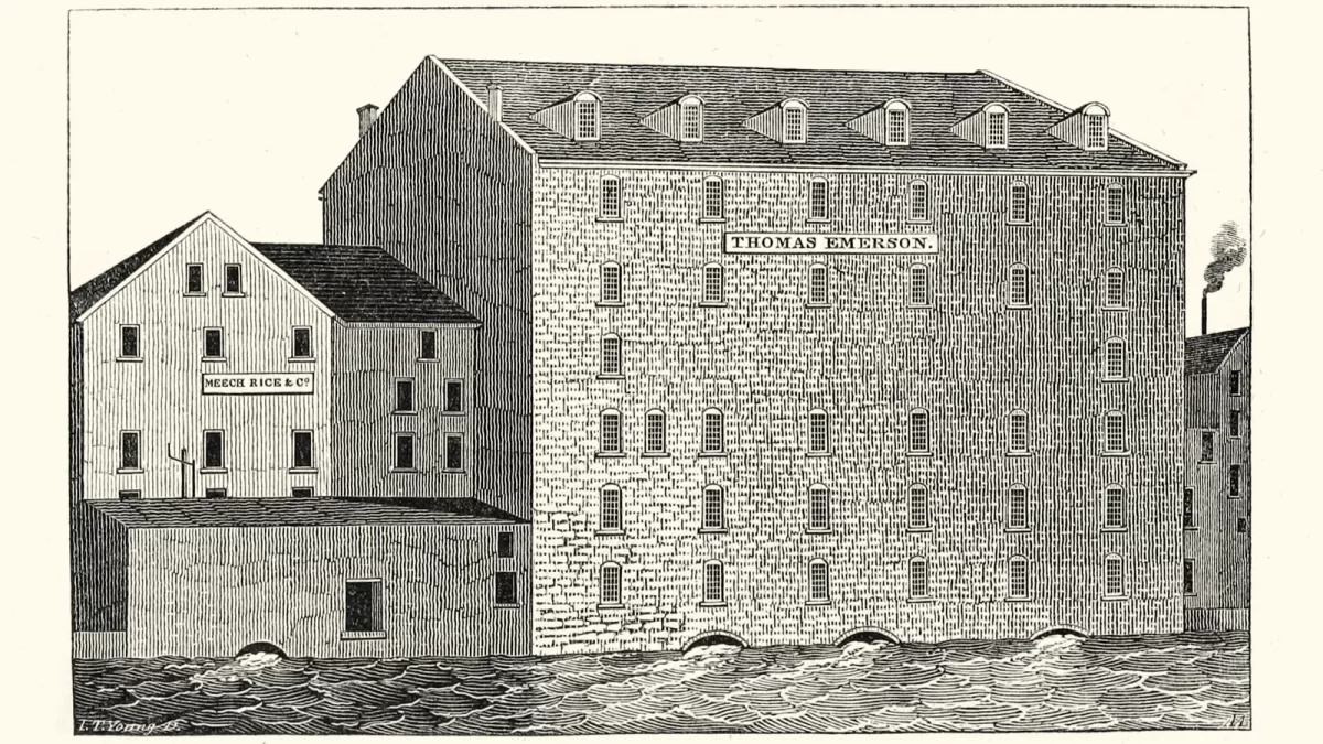
The terms of the lease have not surfaced, but Rochester may have sweetened the deal by making it rent-free, at least initially.12 At any rate, the Elys and their partner Josiah Bissell Jr. proceeded to build their four-story mill and finished it with a coat of red paint.
Rochester, Fitzhugh, and Carroll remained steadfast in their commitment not to sell any mill seats in the Hundred Acre Tract. Not even to family: Nathaniel Rochester, whose son John C. Rochester and son-in-law Harvey Montgomery built a sawmill near the Red Mill, retained ownership of the property and required a lease for the mill.13
After building a store, a sawmill, and a gristmill in the Hundred Acre Tract, Ely & Co. hedged their bets in 1815 by purchasing two lots from Stone.14 They also leased a third lot that included a sawmill;15 two years later Hervey Ely would build a second, larger sawmill next to it.16 North of the sawmills stood a carding machine and woolen clothworks with a yard full of tenter bars on which the fulled cloth was stretched to dry.17
Stone’s efforts to develop his Brighton property had been haphazard. Contracts drawn up for the mill lots he sold included a section committing him to build a raceway to supply water to them. But he never got around to building it. William Atkinson used the lots he occupied to store lumber and barrels while he waited for the water that someday would power a mill.18
“The capitalist and the man of enterprize”
So things stood until 1817, when Elisha Johnson arrived at the Genesee Falls.
A Yankee from Wells, Vermont, Johnson had relocated as a young man to western New York, where he found work as a surveyor.19 He had come to the Falls at the behest of the founders of Carthage, and for them Johnson laid out a classic New England town with a promenade along the edge of the gorge and a central square.20
When he was finished he may have looked south to Enos Stone’s farm and sensed an opportunity.
Exhibiting some skill as an entrepreneur as well as a surveyor, Johnson negotiated the purchase of Stone’s farm and a mortgage (financed by Stone) that would allow him to pay off its $10,000 price over ten years with no interest. The terms of the mortgage also required Johnson to build the millrace that Stone had for so long put off.21 Johnson then sold a fifty percent stake in his purchase to a group of Canandaigua investors. They agreed to pay Johnson $10,000 in several installments over five years with interest, and to pay half of his mortgage to Stone. The investors — Orson Seymour, Harris Seymour, and Punderson B. Underhill — also agreed to pay for half of the new raceway.22
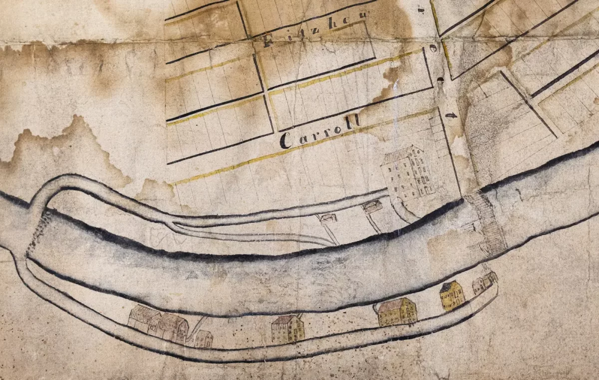
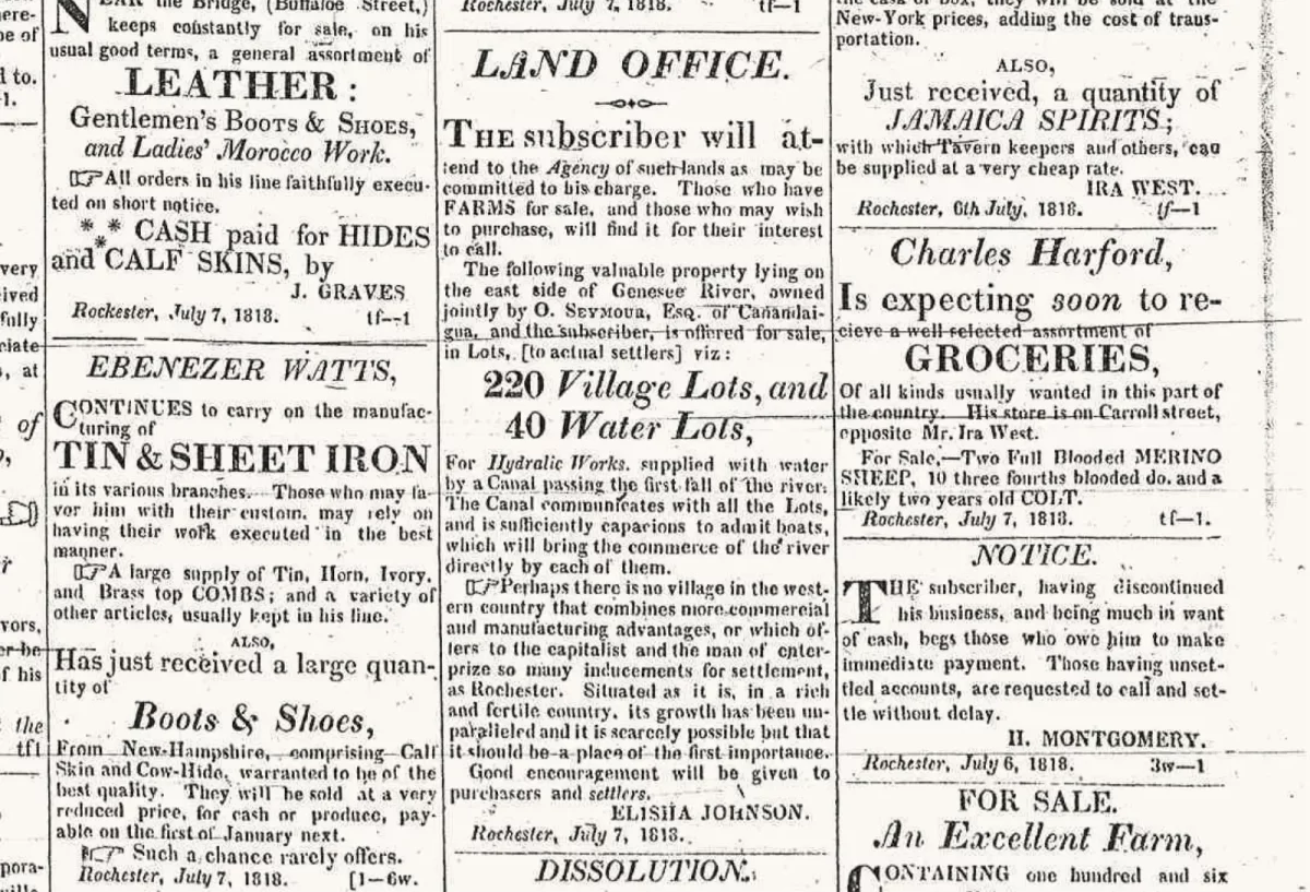
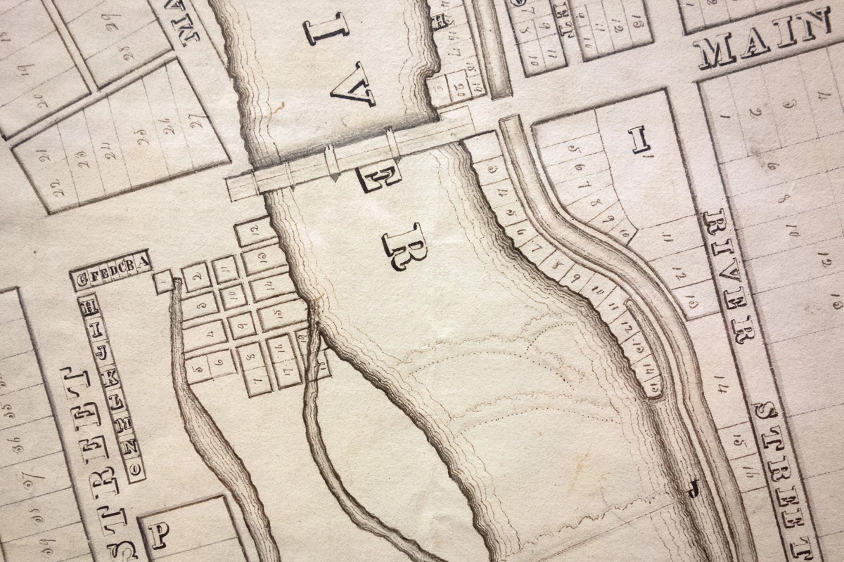
Mortgaged to the hilt, Johnson did not stop there. He made a proper survey, laying down streets, town lots, mill seat lots, and a public square.23 (He later would have the resulting map professionally engraved and printed.) He opened a land office on his new Main Street and, to attract purchasers, placed ads in newspapers across the Northeast. When he boasted in the advertisement that “there is no village in the western country . . . which offers to the capitalist and the man of enterprize so many inducements for settlement, as Rochester,” he may have had himself in mind.24
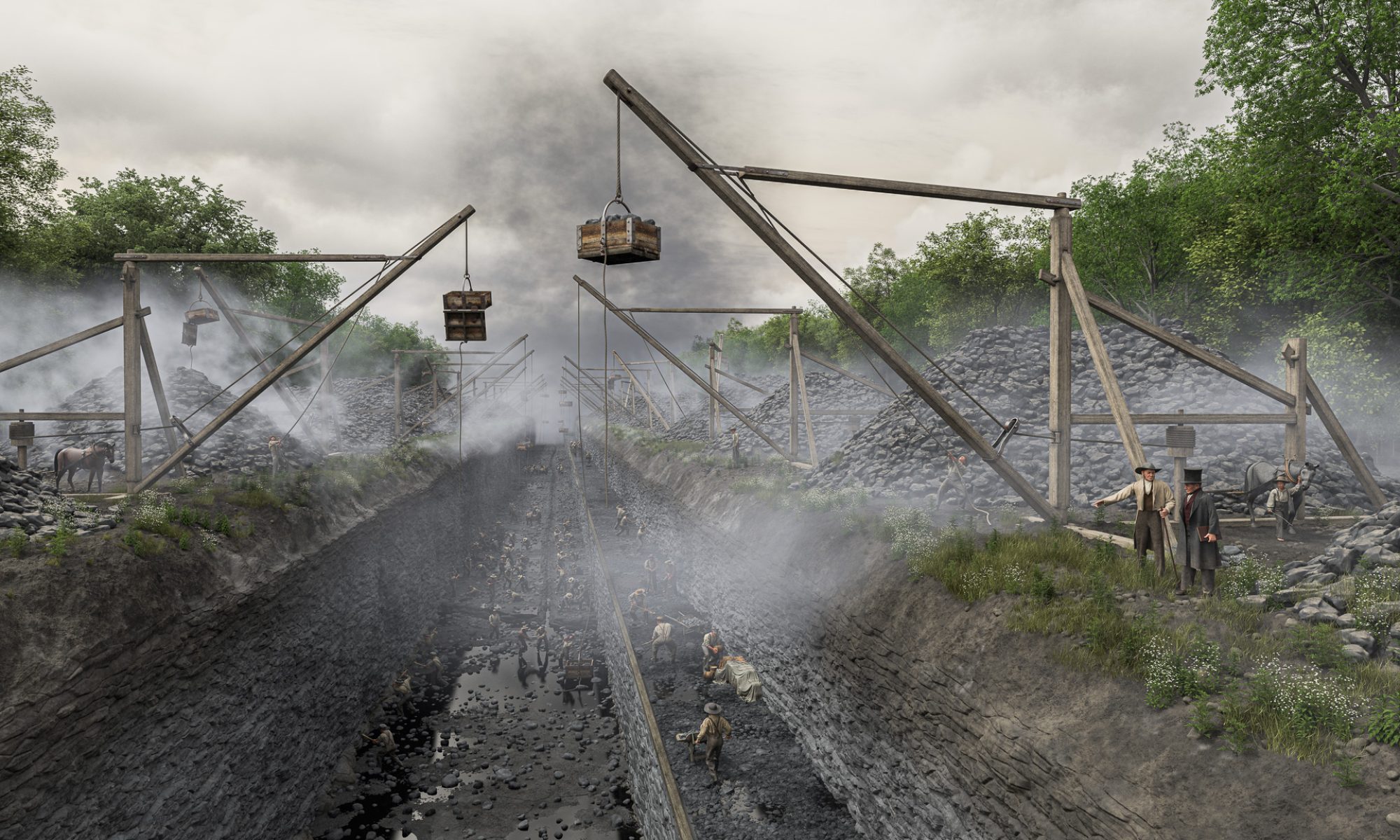
He also began blasting a channel for the long-awaited raceway.
It was a massive and expensive undertaking. The dam and raceway — four feet deep, up to 60 feet wide, and a thousand feet long — would reportedly end up costing $12,000. By the end of the year the raceway extended to lot No. 4, on which Atkinson’s new mill, painted bright yellow and containing three run of stones, could now open for business.25
More development followed. In 1818 Derick Sibley and partner Harvey Gilman purchased mill seat lot No. 8, built a three-story paper mill, and were soon making newsprint for the Rochester Telegraph.26 On lot Nos. 1 and 2, north of the Yellow Mill, Johnson’s younger brother William opened a flax-seed oil mill and a woolen mill.27
East side, west side
Ten days after buying Enos Stone’s Brighton farm, Johnson had written to Nathaniel Rochester with a business proposition:
“In the course of this week I propose adopting a plan of opperation in relation to the water priviledges opposite to yours at this place . . . & considering that a plan ought to be adopted that would be mutually for our interests & believing some improvement may be made that would particularly be for your benefit, makes me anxious to see you at this place the latter part of this week.”28
Johnson’s “plan of opperation” involved the construction of a mill dam across the river above the Upper Falls. The dam would impound the water and divert it into the raceways on both banks. The water would be shared fifty-fifty. Johnson also may have proposed sharing the cost of building guard gates on each of the races as well as a few property adjustments. We do not know, because the terms of the contract have not survived. But either they were not clearly defined or there was willful misunderstanding of what they meant, because the agreement and the dam would become a source of vexation and conflict for years to come.
Charles Carroll would forever remain suspicious of Johnson. Months later, after the troubles began, he would confess that when Johnson made his proposal “I suspected something sinister, for ‘timeo Danaos & dona ferentes’ & I wanted no compromise or terms with them.”29
Competition from Johnson may have prompted a suggestion by Rochester to improve the raceway on his side by moving it slightly west, where it would extend further along the natural rock shelf. “It would give us more fall,” he wrote to his partners, “and more Mill Seats.”30 Rochester, Carroll, and Fitzhugh that summer signed an agreement to divide up the remaining unsold properties in the Hundred Acre Tract.31
Unlike Rochester and his partners, Johnson had no qualms about selling the mill seats he had so meticulously plotted out. His goal was to make a quick profit and they were immediately put on the market.
The different approaches may have been partly cultural. Rochester, Carroll, and Fitzhugh, southerners all, traced their lineage back to a traditional society where most property was controlled by an aristocracy of land-owning families and worked by slave labor.
Johnson was from New England, where the colonial tradition of owning land in common had given way to individual fee-simple ownership. Combined with an unabashed preoccupation with making money, this could sometimes result in extreme land speculation schemes. Oliver Phelps and Nathaniel Gorham, fellow New Englanders who had been the first to try their hand at real estate in western New York, had purchased millions of acres but soon after had to surrender a large part of their investment and sell out. Johnson’s project was much smaller scale, but it was a still a calculated risk.
There also was a physical difference between the two sides. Johnson’s mill seats and raceway were protected by a high, stony bank. Those on the west side were built on a low alluvial deposit that sloped gradually up to the rocky shelf on which the village of Rochesterville was laid out. Wittingly or not, Rochester and his partners were erecting their industrial infrastructure — raceway, mills, and warehouses — in a flood zone.32
“Low down as the bed of the river — to the rock”
The Genesee’s last major flood had been in 1803, before the area had been settled. That was the one that had carried off the remains of Ebenezer Allan’s sawmill.33
Now the river struck again.
The Freshet of 1817 would be widely reported as one of the worst floods in memory. The weather system that spawned it covered much of the country, raising rivers and spreading misery from the Ohio to the Susquehanna.34
In western New York the rain began falling on Friday, October 31, and it did not abate until the following Sunday morning. By then the Genesee River had spilled over its banks and inundated the flats between Geneseo and Leicester. The torrent damaged the toll bridge between those settlements and swept away fields of corn and wheat ready for harvest. At Avon two wagons and their teams were lost when the ferry carrying them became fouled against a bridge. At Allen’s Creek an entire flock of sheep was carried off. And in Leicester several families had to be rescued by boat, with one family desperately removing their cabin roof for use as a raft.35
A few days later the crest reached Rochesterville. It flooded the raceways, undermined John Rochester’s sawmill, and washed away several feet of the riverbank near the west end of the bridge, taking several structures with it.
“The river has continued to rise since you left here,” John C. Rochester wrote to his father on November 7. “It’s taken away the shop built by Curtis & 1 part & all the under work of my saw mill. . . . The village has been constantly busy securing the West end of the Bridge & Mr. Johnson’s race towards the head which broke away two or three times.”36
As the water subsided the extent of the damage became clear. “It has worn away very little above the race,” John wrote. But “the land where Curtises shop the Slaughter house & store is extremely washed away . . . low down as the bed of the river — to the rock.”37
The November 19 edition of the Geneva Gazette summed it up. “At Rochester, two buildings were swept away, and considerable damage done to the mills, dams, &c. by the late flood.”38
Charles Carroll at once recognized a longer-term consequence of the flood — bad publicity — and was quick to assign blame. He was certain that the damage had been aggravated by the height of the new mill dam and hinted that Johnson may have built it that way on purpose. “We have already in public estimation sustained irreparable injury by the report of the destruction of the mills & the inundation of the Village,” he wrote. “It is all important to us, & the more we suffer in the eyes of the Public, the better for Brighton. I have learnt enough of Yankees to dread & fear their wiles & offers . . . Take heed my frd or they will be yr ruin.”39
The flood of 1817 would be followed by many others. When high water again threatened his raceway in early February 1819, a weary Nathaniel Rochester begged Elisha Johnson for help: “I have been busily engaged since I wrote you last with four Irishmen endeavoring to secure the guardlock with frozen sod and some stones, having nothing else to do it with, and I fear they will do no good. . . . I am very low in spirit, and know not what to do for the best.”40
Rochester and his fellow citizens were being schooled in the river’s annual rhythm: high water in late fall, high water again in winter or early spring (often accompanied by ice), and a dry spell that spanned late summer and early fall. It was a harsh lesson. The dry season coincided with the grain harvest, the busiest time for the village’s nascent milling industry. Then the mills needed every drop of water they could get. The dam would stay.
The floods of 1817 and 1819 had other consequences.
Perhaps exhausted by the worry and effort needed to protect and maintain his property, and beset with unrelated financial problems, the now 67-year-old Nathaniel Rochester redoubled his efforts to liquidate his remaining real estate holdings in the Hundred Acre Tract. This included his mill seats, beginning with lot No. 12 near the west end of the bridge, which was divided between Thomas Morgan’s nail factory and blacksmith William Cobb’s triphammer mill.41
In 1822, Rochester, Fitzhugh and Carroll signed a new partition agreement to merge and reorganize the mill lots.42 The lease for John C. Rochester’s sawmill was assumed by Rochester’s son-in-law, Jonathan Child, who also bought its lot, No. 6, along with several other properties.43 Rochester sold neighboring lot No. 5 to his son Thomas H. Rochester and other son-in-law Harvey Montgomery.44 On it they constructed the tract’s second gristmill. It, too, was painted red, and became known as the New Red Mill.45 Finally, the original Red Mill and its lot, No. 2, were sold to Ebenezer S. Beach.46
“The most safe and cheap passing of the Genesee river”
The floods also may have influenced the Erie Canal commissioners’ decision in late 1819 to build a stone aqueduct across the Genesee River.
The idea of building an aqueduct had been around at least since 1811, when it was mentioned in the canal commissioners’ first annual report to the state legislature.47 But since then James Geddes, the engineer most familiar with Rochester, had recommended using a slackwater crossing instead.48 When he completed his survey of the Western Section in 1816, that is what was shown on his map and described in his report to the Canal Commission.49
Slackwater crossings sometimes were used to traverse rivers that obstructed the line of the canal. The canal would be connected to the river, which was dammed below the crossing to create a pond of still water on which boats could safely cross. Guard locks on both sides of the crossing would lower the boats to the level of the river and prevent it from flooding the canal during periods of high water. The horse or mule teams that towed the boats would cross on a timber bridge.
They were seen as simpler alternatives to aqueducts. But tying unpredictable rivers to the canal was risky. Destructive floods could render a crossing unusable and might damage the canal. Dry spells might strand boats and back up traffic for weeks.
But it was understood that Geddes’s 1816 survey was subject to change. Three years later, as the canal commissioners prepared to let contracts for the Western Section, fresh survey teams were dispatched.50 The team led by engineer Canvass White would begin at Rochester and head east. He was specifically instructed by Commissioner Myron Holley to “ascertain carefully where the Genesee could best be crossed.”51
When he visited Rochester that summer, White may have viewed firsthand some of the lingering evidence of the recent floods and realized that it was high time to scrap the notion of a water-level crossing and build an aqueduct instead. If he needed more encouragement, all he had to do was take a good look at Elisha Johnson’s raceway. It pointed like an arrow to the base of the Upper Falls, where the water was shallow and the rocky riverbed would make a perfect foundation for a large masonry structure.
The state had granted almost unlimited power to the canal commissioners to seize any property they needed to complete the canal.52 Elisha Johnson had already done the hard work of blasting a channel that could now serve as the eastern approach to an aqueduct that would cross the river in the very heart of the village. It was just the right size. All they had to do was take it.
Which is what they did. To compensate Johnson, a new raceway would be built parallel to the canal in the bed of the river.53
At the October meeting of the canal commissioners in Utica, Chief Engineer Benjamin Wright reported on the results of the new surveys and offered three options for the canal route between the Seneca and Genesee rivers. The second option, Wright noted, included “the advantages of the most safe and cheap passing of the Genesee river, by an aqueduct near the bridge at Rochester, where rock-bottom to the river and stone for the structure are at hand.”54 The commissioners selected this option by a vote of three to one.55 At last the way was clear.
By then the Canal Commission and its cadre of self-taught engineers had been toiling away on the Erie Canal for more than two years. They were justifiably proud of what they had accomplished and this may have influenced their decision. A stone aqueduct over the Genesee River would comprise “the greatest mass of mason work contained in any one structure” on the canal.56
They were confident they could build it. Why not try?
- Documents of the Assembly of the State of New-York, Seventy-Seventh Session, vol. 2 (Albany: C. Van Benthuysen, 1854), doc. no. 63: “Communication from the Canal Appraisers in Relation to the Claims of Jacob Graves and Others, Mill Owners, at Rochester,” p. 59, transcription of a statement by Hervey Ely; imaged at HathiTrust (https://hdl.handle.net/2027/uiug.30112105707969 : accessed 12 December 2023) > image 599. ↩︎
- Henry E. Rochester, “The Genesee River and Western New York,” Publications of the Rochester Historical Society (Rochester, New York: Rochester Historical Society, 1892), 1:67. ↩︎
- Maude Motley, “The Romance of Milling: With Rochester the Flour City,” Centennial History of Rochester, New York, ed. Edward R. Foreman (Rochester, New York: Rochester Historical Society, 1931), 1:175. ↩︎
- William F. Peck, Semi-Centennial History of the City of Rochester (Syracuse, New York: Mason & Co., 1884), 78. ↩︎
- Colonel Nathaniel Rochester’s Account Book [1811–1822]; Nathaniel Rochester Papers; Rochester Historical Society, Rochester, New York; Rochester Public Library microfilm Rr333.333 R676c; Rochester Public Library, Rochester, New York. ↩︎
- Nathaniel Rochester to Elie Beatty, letter, 19 November 1811; Nathaniel Rochester Papers; Rochester Historical Society, Rochester, New York. ↩︎
- Charles Carroll to Nathaniel Rochester, letter, 17 August 1811; Nathaniel Rochester Papers; Rochester Historical Society, Rochester, New York. ↩︎
- Alan Taylor, The Civil War of 1812: American Citizens, British Subjects, Irish Rebels, & Indian Allies (New York: Knopf, 2010), 247. ↩︎
- “Pittsfield Factory,” Pittsfield (Massachusetts) Sun, 7 June 1806, p. 3, col. 4; image copy, Newspapers.com (https://www.newspapers.com/image/531979706 : accessed 21 November 2023). ↩︎
- Howard L. Osgood, “Rochester: Its Founders and Its Founding,” Publications of the Rochester Historical Society, Publication Fund Series (Rochester, New York: Rochester Historical Society, 1922), 1:67. ↩︎
- Nathaniel Rochester to William Fitzhugh, 18 June 1814, letter; Nathaniel Rochester Papers; Rochester Historical Society, Rochester, New York. ↩︎
- Hervey Ely to Nathaniel Rochester, letter, 12 March 1823; Nathaniel Rochester Papers; Rochester Historical Society, Rochester, New York. ↩︎
- Nathaniel Rochester to Harvey Montgomery and John C. Rochester, sawmill lease agreement, 14 March 1816; Nathaniel Rochester Papers; Rochester Historical Society, Rochester, New York. ↩︎
- Ontario County, New York, Land Records, Liber 25:326, Enos Stone to Hervey Ely, Elisha Ely, and Josiah Bissel Jr., 17 January 1814; consulted as “United States, New York Land Records, 1630-1975,” database with images, FamilySearch (https://familysearch.org/ark:/61903/3:1:3QSQ-G9WH-N9MJ-K : accessed 21 November 2023), Ontario > Deeds 1815-1816 vol. 24-25 > image 432 of 511; citing Ontario County Clerk’s Office, Canandaigua, New York. ↩︎
- Documents of the Assembly of the State of New-York, Seventy-Seventh Session, vol. 2 (Albany: C. Van Benthuysen, 1854), doc. no. 63, pp. 223–225, transcription of Enos Stone to Hervey Ely, Elisha Ely, and Josiah Bissell Jr., 1 May 1815; imaged at HathiTrust (https://hdl.handle.net/2027/uiug.30112105707969 : accessed 12 December 2023) > images 763–765. ↩︎
- Documents of the Assembly of the State of New-York, Seventy-Seventh Session, vol. 2 (Albany: C. Van Benthuysen, 1854), doc. no. 63, p. 59, transcription of a statement by Hervey Ely; imaged at HathiTrust (https://hdl.handle.net/2027/uiug.30112105707969 : accessed 12 December 2023) > image 599. ↩︎
- Ontario County, New York, Land Records, Liber 23:240, Isaac Stone to Elisha Cobb, 1 January 1814; consulted as “United States, New York Land Records, 1630-1975,” database with images, FamilySearch (https://familysearch.org/ark:/61903/3:1:3QS7-99WH-J145 : accessed 21 November 2023) Ontario > Deeds 1814-1815 vol 22-23 > image 418 of 601; citing Ontario County Clerk’s Office, Canandaigua, New York. ↩︎
- Documents of the Assembly of the State of New-York, Seventy-Seventh Session, vol. 2 (Albany: C. Van Benthuysen, 1854), doc. no. 63, p. 59, transcription of testimony by Everard Peck; imaged at HathiTrust (https://hdl.handle.net/2027/uiug.30112105707969 : accessed 12 December 2023) > image 616. ↩︎
- John S. Minard, Allegany County and Its People: A Centennial Memorial History of Allegany County, New York (W. A. Fergusson & Co.: Alfred, New York, 1896), 56. ↩︎
- Susan Huntington Hooker, “The Rise and Fall of Carthage,” Publications of the Rochester Historical Society, Publication Fund Series (Rochester, New York: Rochester Historical Society, 1922), 2:207. ↩︎
- Ontario County, New York, Land Records, Liber 28:98, Enos Stone and Clarisa his wife to Elisha Johnson, 6 May 1817; consulted as “United States, New York Land Records, 1630-1975,” database with images, FamilySearch (https://familysearch.org/ark:/61903/3:1:3QS7-99WH-J7L7 : accessed 21 November 2023), Ontario > Deeds 1817-1818 vol 28-29 > image 54 of 571; citing Ontario County Clerk’s Office, Canandaigua, New York. Ontario County, New York, Mortgages, 8:375, Elisha Johnson and Betsy [sic] his wife to Enos Stone, 6 May 1817, consulted as “United States, New York Land Records, 1630-1975,” database with images, FamilySearch (https://familysearch.org/ark:/61903/3:1:3QS7-L9WX-SWRT : accessed 21 November 2023), Ontario > Mortgages 1814-1817 vol 7-8 > image 498 of 644; citing Ontario County Clerk’s Office, Canandaigua, New York. ↩︎
- Ontario County, New York, Land Records, Liber 28:417, Elisha Johnson and Betsey his wife to Punderson B. Underhill, Harris Seymour, and Orson Seymour, 24 July 1817; consulted as “United States, New York Land Records, 1630-1975,” database with images, FamilySearch (https://familysearch.org/ark:/61903/3:1:3QS7-99WH-J4X8 : accessed 21 November 2023), Ontario > Deeds 1817-1818 vol 28-29 > image 217 of 571; citing Ontario County Clerk’s Office, Canandaigua, New York. ↩︎
- The public square would become Rochester’s Washington Square Park. ↩︎
- “Land Office,” The New-York Columbian, 6 January 1818, p. 3, col. 1; image copy, Readex: America’s Historical Newspapers (access through participating libraries : accessed 14 November 2023). ↩︎
- A Directory for the Village of Rochester: Containing the Names, Residence and Occupations of All Male Inhabitants Over Fifteen Years of Age in Said Village, on the First of January, 1827. To Which is Added, a Sketch of the History of the Village, from 1812 to 1827 (Rochester, New York: Elisha Ely, 1827), 92. ↩︎
- Ontario County, New York, Land Records, Liber 33:245, Elisha Johnson and Betsey his wife and Orson Seymour and Caroline Maria his wife to Harvey Gilman and Derick Sibley, 14 May 1819, consulted as “United States, New York Land Records, 1630-1975,” database with images, FamilySearch (https://familysearch.org/ark:/61903/3:1:3QSQ-G9WH-KKSJ : accessed 21 November 2023), Ontario > Deeds 1818-1819 vol 32-33 > image 452 of 544; citing Ontario County Clerk’s Office, Canandaigua, New York. Gilman and Sibley’s Paper Mill, The Rochester (New York) Telegraph, 13 October 1818, p. 2, col 5; image copy, NYS Historic Newspapers (https://nyshistoricnewspapers.org/?a=d&d=rot18181013-01.1.2&e=——-en-20–1–txt-txIN———- : accessed 21 November 2023). ↩︎
- “Oil Mill . . . Cloth Dressing,” The Rochester (New York) Telegraph, 8 September 1818, p. 3, col. 2; image copy, NYS Historic Newspapers (https://nyshistoricnewspapers.org/?a=d&d=rot18180908-01.1.3&e=——-en-20–1–txt-txIN———- : accessed 21 November 2023). ↩︎
- Elisha Johnson to Nathaniel Rochester, letter, 16 May 1817; Nathaniel Rochester Papers; Rochester Historical Society, Rochester, New York. ↩︎
- Timeō Danaōs et dōna ferentēs: “I fear the Greeks even when bearing gifts,” quoting Virgil’s Aeneid; Charles Carroll to Nathaniel Rochester, letter, 6 November 1817; Nathaniel Rochester Papers; Rochester Historical Society, Rochester, New York. ↩︎
- Nathaniel Rochester to Charles Carroll and William Fitzhugh, letter, 29 September 1817; Nathaniel Rochester Papers; Rochester Historical Society, Rochester, New York. ↩︎
- Genesee County, New York, Land Records, Liber 11:160, Charles Carroll, William Fitzhugh, and Nathaniel Rochester, 13 August 1817; consulted as “United States, New York Land Records, 1630-1975,” database with images, FamilySearch (https://familysearch.org/ark:/61903/3:1:3QS7-L9WR-KZ85 : accessed 21 November 2023), Genesee > Deeds 1817-1818 vol 10-11 > image 354 of 538; Genesee County Clerk’s Office, Batavia, New York. ↩︎
- Documents of the Assembly of the State of New York, Eighty-Ninth Session, vol. 5 (Albany: C. Wendell, 1866), doc. no. 117: “Report of the Commissioners Appointed to Investigate the Causes of the Inundation of the City of Rochester in March, 1865,” p. 18; imaged at HathiTrust (https://hdl.handle.net/2027/coo.31924093488496 : accessed 12 December 2023) > image 1132. ↩︎
- William F. Peck, Landmarks of Monroe County, New York (Boston: Boston History Company, 1895), 148. ↩︎
- Ohio River Rises 40 Feet, Hampden Federalist (Springfield, Massachusetts), 4 December 1817; Readex: America’s Historical Newspapers (access through participating libraries: accessed 18 November 2023). Susquehannah Swelled to an Unusual Height, (New York) Commercial Advertiser, 15 November 1817; Readex: America’s Historical Newspapers (access through participating libraries: accessed 18 November 2023). ↩︎
- “Destructive Flood,” (Cooperstown, New York) Watch-Tower, 27 November 1817, p. 3, col. 1, from the Genesee Farmer; image copy, Readex: America’s Historical Newspapers (access through participating libraries: accessed 14 November 2023). ↩︎
- John C. Rochester to Nathaniel Rochester, letter, 7 November 1817; Nathaniel Rochester Papers; Rochester Historical Society, Rochester, New York. ↩︎
- John C. Rochester to Nathaniel Rochester, letter, 10 November 1817; Nathaniel Rochester Papers; Rochester Historical Society, Rochester, New York. ↩︎
- Two Buildings Swept Away at Rochester, Geneva (New York) Gazette, 19 November 1817, p. 3, col. 1; image copy, NYS Historic Newspapers (https://nyshistoricnewspapers.org/?a=d&d=gg18171119-01.1.3&e=——-en-20–1–txt-txIN———- : accessed 22 November 2023). ↩︎
- Charles Carroll to Nathaniel Rochester, letter, 9 November 1817; Nathaniel Rochester Papers; Rochester Historical Society, Rochester, New York. ↩︎
- Nathaniel Rochester to Elisha Ely, letter, 4 November 1819; Nathaniel Rochester Papers; Rochester Historical Society, Rochester, New York. ↩︎
- Genesee County, New York, Land Records, Liber 14:180, Nathaniel Rochester to Thomas Morgan, 9 November 1819; consulted as “United States, New York Land Records, 1630-1975,” database with images, FamilySearch (https://familysearch.org/ark:/61903/3:1:3QS7-89WR-ZJ7L : accessed 22 November 2023), Genesee > Deeds 1818-1823 vol 14-15 > image 391 of 607; citing Genesee County Clerk’s Office, Batavia, New York. Monroe County, New York, Land Records, Liber 28:473, Nathaniel Rochester to William Cobb, 9 November 1819; consulted as “United States, New York Land Records, 1630-1975,” database with images, FamilySearch (https://familysearch.org/ark:/61903/3:1:3QS7-99WF-Q3V : accessed 22 November 2023), Monroe > Deeds 1833-1834 vol 28 > image 485 of 595; Monroe County Clerk’s Office, Rochester, New York. ↩︎
- Monroe County, New York, Land Records, Liber 2:117, Charles Carroll, Nathaniel Rochester, and William Fitzhugh, 19 September 1822; consulted as “United States, New York Land Records, 1630-1975,” database with images, FamilySearch (https://familysearch.org/ark:/61903/3:1:3QS7-99WF-7ZZW : accessed 22 November 2023), Monroe > Deeds 1822-1823 vol 2 > image 120 of 550; Monroe County Clerk’s Office, Rochester, New York. ↩︎
- Monroe County, New York, Land Records, Liber 2:131, Nathaniel Rochester and Sophia, his wife, to Jonathan Child, 8 October 1822; consulted as “United States, New York Land Records, 1630-1975,” database with images, FamilySearch (https://familysearch.org/ark:/61903/3:1:3QS7-89WF-7D4K : accessed 22 November 2023), Monroe > Deeds 1822-1823 vol 2 > image 134 of 550; Monroe County Clerk’s Office, Rochester, New York. ↩︎
- Monroe County, New York, Land Records, Liber 2:256, Nathaniel Rochester and Sophia, his wife, to Harvey Montgomery and Thomas H. Rochester, 25 December 1822; consulted as “United States, New York Land Records, 1630-1975,” database with images, FamilySearch (https://familysearch.org/ark:/61903/3:1:3QS7-L9WF-789D : accessed 22 November 2023), Monroe > Deeds 1822-1823 vol 2 > image 259 of 550; Monroe County Clerk’s Office, Rochester, New York. ↩︎
- “New Red Mill,” The Rochester (New York) Telegraph, 17 December 1822, p. 3, col. 4; image copy, NYS Historic Newspapers (https://nyshistoricnewspapers.org/?a=d&d=rot18221217-01.1.3&e=——-en-20–1–txt-txIN———- : accessed 22 November 2023). ↩︎
- Monroe County, New York, Land Records, Liber 1:208, Charles Carroll and Ann his wife, William Fitzhugh and Ann his wife, and Nathaniel Rochester and Sophia his wife to Ebenezer S. Beach, 14 August 1821; consulted as “United States, New York Land Records, 1630-1975,” database with images, FamilySearch (https://familysearch.org/ark:/61903/3:1:3QSQ-G9WF-Q7SK : accessed 22 November 2023), Monroe > Deeds 1821-1822 vol 1 > image 211 of 749; Monroe County Clerk’s Office, Rochester, New York. ↩︎
- Laws of the State of New York, in Relation to the Erie and Champlain Canals, vol. 1 (Albany: E. and E. Hosford, 1825), 61, 66; imaged at HathiTrust (https://hdl.handle.net/2027/hvd.hwsr1t : accessed 12 December 2023) > images 79, 84. ↩︎
- Laws of the State of New York . . . Canals, vol. 1, p. 145; imaged at HathiTrust (https://hdl.handle.net/2027/hvd.hwsr1t) > image 163. ↩︎
- Laws of the State of New York . . . Canals, vol. 1, p. 213; imaged at HathiTrust (https://hdl.handle.net/2027/hvd.hwsr1t) > image 235. ↩︎
- Laws of the State of New York . . . Canals, vol. 1, p. 451; imaged at HathiTrust (https://hdl.handle.net/2027/hvd.hwsr1t) > image 475. ↩︎
- Myron Holley to Henry O’Reilly, letter, 18 December 1837, in O’Reilly, Settlement in the West. Sketches of Rochester; with Incidental Notices of Western New-York (Rochester: William Alling, 1838), 220. ↩︎
- Laws of the State of New York . . . Canals, vol. 1, p. 360: “An Act Respecting Navigable Communications, Between the Great Western and Northern Lakes, and the Atlantic Ocean,” sect. 3; imaged at HathiTrust (https://hdl.handle.net/2027/hvd.hwsr1t) > image 384. ↩︎
- Documents of the Assembly of the State of New-York, Sixty-Second Session, vol. 5 (Albany: E. Croswell, 1839), doc. no. 283: “Report of the Committee on Canals and Internal Improvements on the Several Memorials of Hervey Ely, Wm. Fitzhugh, Jonathan Child, Thomas Kempshall, Joseph Strong, Maltby Strong and John T. Potter,” p. 5–6, transcription of mill owners’ memorial; imaged at HathiTrust (https://hdl.handle.net/2027/uc1.b2998836 : accessed 12 December 2023) > images 435–436. ↩︎
- “The Grand Canal,” Geneva (New York) Gazette, 19 November 1819, p. 2, cols. 3–4, from the Albany Register; image copy, NYS Historic Newspapers (https://nyshistoricnewspapers.org/?a=d&d=gg18191110-01.1.2&e=——-en-20–1–txt-txIN———- : accessed 22 November 2023). ↩︎
- Myron Holley to Henry O’Reilly, letter, in O’Reilly, Settlement in the West, 220. ↩︎
- Laws of the State of New York . . . Canals, vol. 2, p. 100; imaged at HathiTrust (https://hdl.handle.net/2027/hvd.hwsr15) > image 136. ↩︎