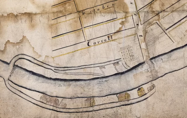
Rochester’s early industrial development is depicted in this detail taken from a hand-drawn, early 19th-century map. North is to the right; the Genesee River flows from south to north, with artificial mill races branching off either side to supply water power to several mills and factories. On the west side of the river (top), from left to right: the sawmill of John C. Rochester and Harvey Montgomery; and the sawmill and the Red Mill of Hervey Ely & Co. On the east side, from left to right: Hervey Ely’s two sawmills and wool carding machine; the paper mill built in 1818 by Derrick Sibley and Harry Gilman; William Atkinson’s Yellow Mill, built in 1817; an unidentified mill; and William Johnson’s oil and woolen mills, built in 1818. The map’s origin and date are uncertain, though the lack of any reference to the Erie Canal and aqueduct would seem to place it before the summer of 1821. The unidentified mill may be Harvey Ely’s Etna Mill, completed in 1822 (and perhaps added to the map then). Also included is a (possibly unique) depiction of the first Buffalo Street bridge, a wooden structure built in 1812 and replaced in 1824. (Rochester Historical Society)


