The Genesee River is the star of the show when it comes to the early history of Rochester. All the other players come and go, but the river is always there.
Rising in the northern highlands of Pennsylvania, the Genesee drops some 2,000 feet on its way to Lake Ontario. Much of the descent occurs over two sets of magnificent waterfalls, one in Letchworth State Park, the other in downtown Rochester. It is named after the Seneca word for the surrounding landscape, often translated as “beautiful valley.” But the Seneca themselves from long familiarity and use had many names for the river. One was particularly appropriate — “river of many falls.”1
“They call this River Casconchiagon,” wrote the Jesuit priest and explorer Pierre François Xavier de Charlevoix in a letter home to France in May 1721. He had reached an outpost on the Niagara River and met “M. de Joncaire, Captain in the Troops of New France,” who gave him this first-person account of the river, which lay some distance to the east:
“Two Leagues from its Mouth, we are stopped by a Fall which appears to be sixty Feet high, and one hundred and forty Yards wide. A Musket Shot higher, we find a second of the same Width, but not so high by two thirds. Half a League further, a third, one hundred Feet high, good Measure, and two hundred yards wide. After this, we meet with several Torrents; and after having sailed fifty Leagues further, we perceive a fourth fall, every way equal to the third.”
The good Father Charlevoix, who must have paddled past the river on his voyage west, ruefully wrote that he would have visited it himself if only he “had been sooner informed of its Singularity.”2
A hundred acres and a waterfall
The Genesee Country would be opened to white settlement within a couple of generations of Charlevoix’s visit. During the American Revolution the indigenous occupants, the Senecas, were defeated by the Continental soldiers of General John Sullivan, their fields and villages laid to waste. Afterward, when those soldiers returned home, their accounts of the fertile country to the west caught the ears of speculators eager to make another kind of killing.
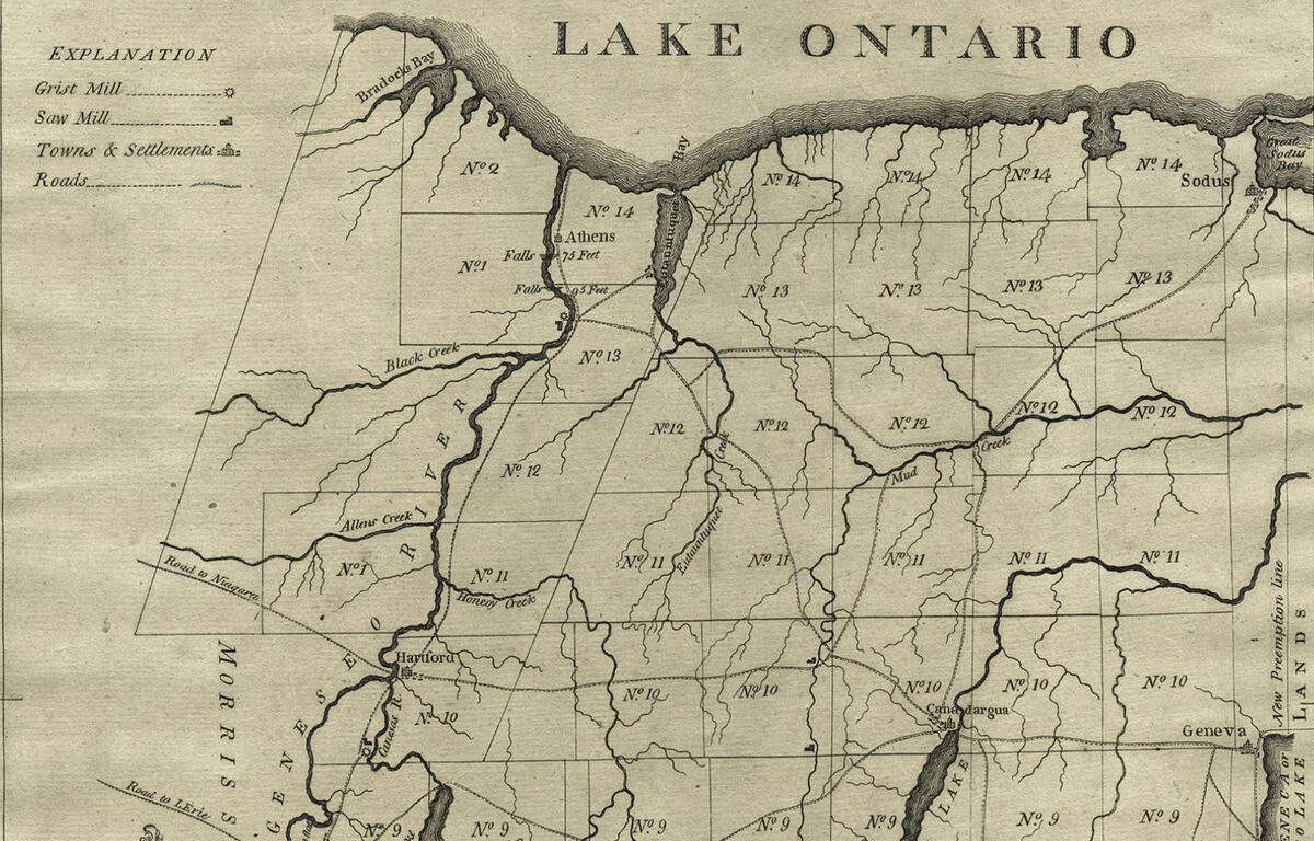
A group of investors led by Oliver Phelps and Nathaniel Gorham in 1788 purchased the preemption rights to western New York, allowing them to negotiate with the Senecas who, in principal, still held title to the soil.
The Senecas, unwilling to part with all of their territory, sold everything east of the Genesee, about 2.6 million acres, for $5,000 or a little more than five cents an acre. In a concession to Phelps they included a diagonally shaped tract west of the river, about twelve miles by twenty-four, for use as a “mill lot.” In return, Phelps promised to establish a sawmill and gristmill to serve native inhabitants and white settlers alike.3
An Indian trader named Ebenezer Allan agreed to operate the mills, and Phelps sold or gave to him a smaller tract of one hundred acres on which to build them.
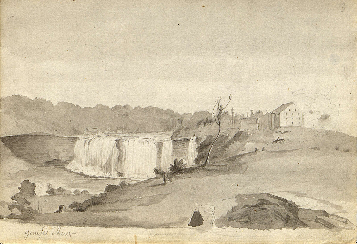
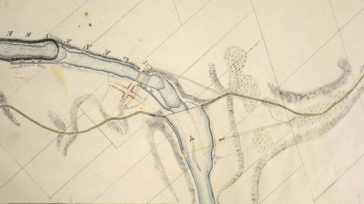
Allan’s tract was adjacent to a stretch of rocky ledges and rapids known as the Upper Falls, so named because they were the first in a series of four cataracts over which the Genesee River tumbled on its way to Lake Ontario. The Upper Falls dropped a mere 14 feet – nothing compared to the mighty 96-foot-high Middle Falls a half-mile downstream. If you were to visit downtown Rochester today you would find no sign of them. But in the early 19th century the power they could generate was sufficient to drive many mills and factories.4
Allan turned out to be a poor millwright. His crudely constructed mills were inefficient and inaccessible to early settlers, and in 1792 he sold the falls tract and moved away. The tract passed through several hands before being contracted for purchase in 1803 by Nathaniel Rochester, William Fitzhugh, and Charles Carroll, three Maryland businessmen visiting on a tip from a local land agent. Impressed with the tract’s potential, they signed a contract, agreeing to buy the hundred acres for $1,750 to be paid in five annual installments.5
It was a cold-eyed real-estate investment that may have been underwritten in part by Rochester’s slave-trading business back home.6
“A nest egg for Posterity”
At first, none of the three partners was willing to relocate to the new property. Rochester established a large farm, complete with gristmill, sawmill, and paper mill, at Dansville, about 40 miles south. Carroll and Fitzhugh remained in Maryland, leaving to him the hands-on management of their “estate.”
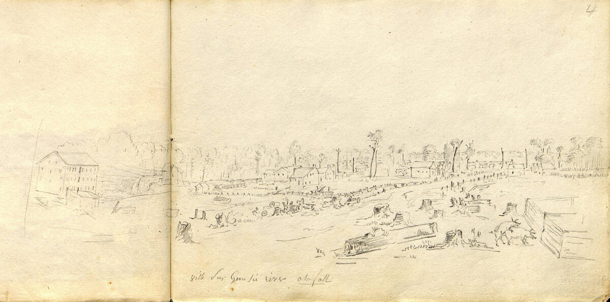
In the late summer of 1811 Rochester surveyed the purchase, plotting it out as a simple grid. He envisioned a mercantile future for his “paper city” and omitted a town square and located property reserved for civic functions (such as a future courthouse) away from the community center. That space instead was filled with narrow, high-priced lots to encourage commercial use.7
All was done in consultation with Carroll and Fitzhugh. In a long, advice-filled missive to Rochester, Carroll urged him to hold back any property suitable for water-powered industry: “We perfectly accord with you in sentiment as to the advantage of laying out a Town & selling building lots . . . & this you are fully authorized to do, but by no means to sell any ground that can in any possible manner or shape injure or interfere with any scites [sic] or situations for water works.”8
Heeding Carroll’s words, Rochester reserved a large undivided parcel adjacent to the Upper Falls that could accommodate several mills and warehouses. He named it, simply, “Mill Yard.”
Nothing “should induce us to divest ourselves of the fee in any part of that Property,” Carroll had emphasized. “We hold it as a nest egg for Posterity . . . & scarcely any given sum would weigh with me one moment to divide or part with it.”9
For the three partners, this was the money lot.
“Their destroying attention”
The Hundred Acre Tract plays an outsize role in the popular history of Rochester. As the village and then city prospered and grew over the course of the 19th century — and it did, spectacularly — the rough outlines of its early years would be worn smooth by the fading memories of its original settlers and their children. But the fact is that for years after its establishment Rochesterville persisted as a remote, rattlesnake-infested foothold in the wilderness, virtually inaccessible to overland travelers. In more ways than one, it was a community on the brink.
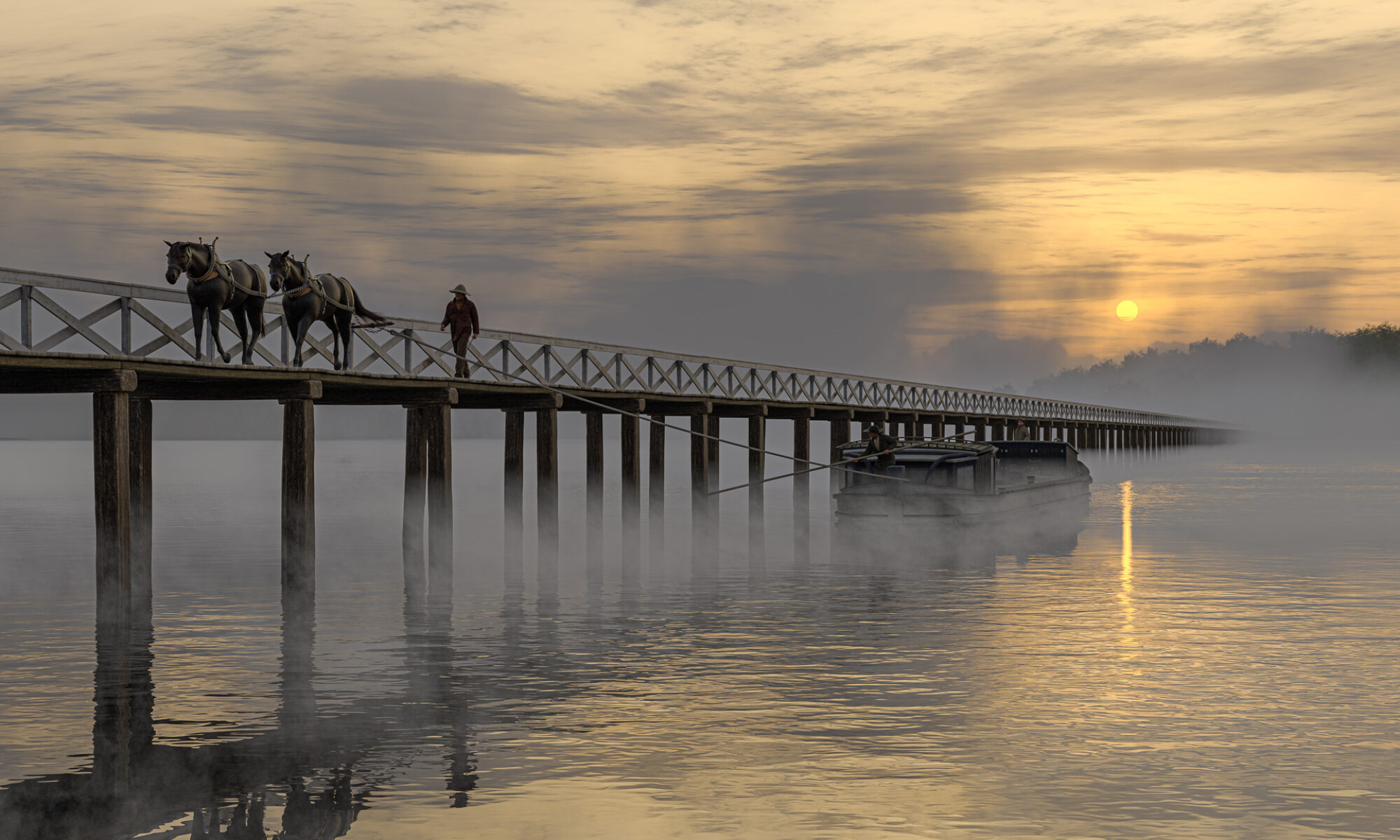
The little settlement’s isolation was eased somewhat in 1812 when a wooden bridge was built across the river along Buffalo Street, its main thoroughfare — just in time for the outbreak of hostilities along the Niagara Frontier.
War with Great Britain commenced with much fanfare and bluster that June with a declaration of war by Congress and an invasion of Upper Canada. The campaign, doomed by poor planning and incompetent leadership, drew to a close in December 1813 with American General George McClure penned up in Fort George on the Canadian side of the Niagara River. The British forces closing in included disciplined regulars who had long experience fighting on the Continent and elsewhere for the Empire. McClure, who could muster only about 100 raw United States regulars and Canadian volunteers, made the reasonable decision to retreat to the American side of the river. But before departing he gave the order to burn the nearby village of Newark (now Niagara-on-the-Lake) to the ground, a criminal act that served no purpose and stranded the village’s inhabitants, mostly women and children, in the freezing cold and snow.10
Enraged, the British pursued the Americans across the river and with a ruthless bayonet attack captured Fort Niagara. They then turned south and in retaliation for the immolation of Newark burned the settlements of Lewiston, Youngstown, Manchester (Niagara Falls), Black Rock, and Buffalo, and many isolated homesteads besides.11
The devastation — and fear of the British army’s Native American allies — sent refugees streaming east toward the Genesee River.
“The sufferings of the unfortunate people about Buffaloe [sic] excite the sympathy of all who have heard them,” wrote Fitzhugh to Rochester in early February 1814. “It would seem if the war should continue that every feeling of Humanity would be put to sleep.”12
That spring the settlers of Rochesterville found themselves under attack — or so they thought — when a British squadron unexpectedly appeared off the mouth of the Genesee River. According to a later account “all the male inhabitants of the village, capable of bearing arms (being 33), turned out with the militia of the neighboring towns,” to prevent a landing. But the village’s remoteness from the lake and a lack of satisfactory targets gave the British little incentive to attempt one. After a desultory volley or two the commander, Sir James Yeo, sailed off.13
In other words, Rochesterville likely was spared the fate of the Niagara Frontier because it was still in such a backward state — a detail that was not lost on Rochester and his partners.
“I observed by way of the eastern papers that the Enemy had been at no great distance from our Mill Seat at Genesee Falls,” noted Fitzhugh. “It is well perhaps the village was not improved with mills [and other] buildings which might have claimed their destroying attention.”14
“They crossed the river yesterday”
The treaty of Ghent was signed at the end of 1814 and within a few weeks hostilities sputtered to a close. By then a few more tentative steps had been taken at the Hundred Acre Tract. A sawmill was raised in 1813, followed the next year by the Red Mill, the tract’s first gristmill since Allan’s failed effort twenty years before.
In the meantime, reports began to filter in from Albany about a new and massive state project. The details were far from certain, but the proposed “monstrous canal,” in Fitzhugh’s words, which would connect the waters of Lake Erie with the Hudson River, had the potential to change everything. “What distance will the canal run from our mill seat?” he asked. “Not far I think by the direction it takes upon the map.”15
Rochester’s reply came a few weeks later: “The route for the Canal . . . crosses the Genesee River on our Land immediately above the falls, about where we forded the River twelve years ago. The advantages that would result to the State of New York, and particularly to this western part of it would be incalculable if it can be accomplished.”16
Planning for the canal had started much earlier, but out of necessity it had been set aside during the war. With the arrival of peace it could resume in earnest. After much political wrangling a skeptical state legislature in April 1816 appointed a board of canal commissioners and instructed them to undertake a new set of surveys. The commissioners wasted no time. James Geddes, who led the survey team east from Tonawanda Creek near Buffalo, was soon approaching the Genesee River.
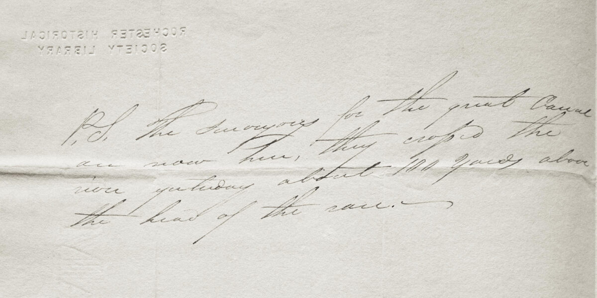
Hervey Ely, one of the builders of the Red Mill, broke the news to Nathaniel Rochester in a postscript to a letter written July 30, 1816: “P.S. The surveyors for the great Canal are now here, they crossed the river yesterday about 100 yards above the head of the race.”17
Once again the Genesee River was front and center. It wasn’t finished with Rochesterville. Not by a long shot.
- Britannica, T. Editors of Encyclopaedia. “Genesee River.” Encyclopedia Britannica, June 11, 2008, https://www.britannica.com/place/Genesee-River. ↩︎
- Pierre François Xavier de Charlevoix. Letters to the Dutchess of Lesdiguieres (London: Goadsby, 1763), 144. ↩︎
- Howard L. Osgood, “The Title of the Phelps and Gorham Purchase,” Publications of the Rochester Historical Society (Rochester, NY: Rochester Historical Society, 1891), 1:20–23. ↩︎
- “Over the years the change in terminology for Rochester’s three waterfalls (originally four) led to much confusion. Going downstream from downtown, the original Upper Falls no longer exists. The old Middle Falls is now the High (or Main, or Upper) Falls, while the Upper Step-Lower Falls is now the Middle Falls and the Lower Step-Lower Falls is currently known as the Lower Falls.” Thomas X. Grasso, “Geology and History of the Rochester Gorge, Part One.” Rochester History 54, no. 4 (Fall 1992), 9. ↩︎
- William Farley Peck, History of Rochester and Monroe County, New York: From the Earliest Historic Times to the Beginning of 1907 (New York: Pioneer Publishing Company, 1908), 1:32. ↩︎
- For a thoughtful treatment of Nathaniel Rochester’s slave-trading past, see Justin Murphy, “Rochester’s founders held people in slavery, but would name changes make up for past injustice?” Democrat & Chronicle, July 20, 2020, https://www.democratandchronicle.com/in-depth/news/2020/07/20/rochesters-founding-fathers-held-people-slavery-does-matter/3256274001/. ↩︎
- Diane Shaw, City Building on the Eastern Frontier: Sorting the New Nineteenth-Century City (Baltimore: John Hopkins University Press, 2004), 30–35. ↩︎
- Charles Carroll to Nathaniel Rochester, 17 August 1811, Nathaniel Rochester Papers, Rochester Historical Society. ↩︎
- Ibid. ↩︎
- Lewis L. Babcock, “The Spoliation of the American Frontier,” chap. 8 in The War of 1812 on the Niagara Frontier (Buffalo, NY: Buffalo Historical Society, 1927), 115–138. ↩︎
- Ibid. ↩︎
- William Fitzhugh to Nathaniel Rochester, 2 February 1814, Nathaniel Rochester Papers, Rochester Historical Society. ↩︎
- A Directory for the Village of Rochester (Rochester, NY: Ely, 1827), 90, in Franklin Hanford, Notes on the Visits of American and British Naval Vessels to the Genesee River, 1809–1814 (Rochester, NY: Genesee Press, 1911), 11–15. ↩︎
- William Fitzhugh to Nathaniel Rochester, 2 February 1814. ↩︎
- Ibid. ↩︎
- Nathaniel Rochester to William Fitzhugh (manuscript copy), 15 March 1814, Nathaniel Rochester Papers, Rochester Historical Society. ↩︎
- Hervey Ely to Nathaniel Rochester, 30 July 1816, Nathaniel Rochester Papers, Rochester Historical Society. ↩︎
Very interesting and detailed read!
Thank you, Patrick!