As James Geddes, Esq., found himself exploring the rivers of central New York in late 1808 on behalf of the state legislature, he believed he had come across a unique opportunity.
He already was familiar with the territory. A native of Carlisle, Pennsylvania, Geddes had settled near Onondaga Lake in 1793. He had been attracted by reports of brine springs in the area, and soon formed a company to manufacture salt. Eventually the community of Geddes grew up around the salt works, and he went on to become a lawyer, justice of the peace, and state assemblyman.
Along the way he had also taken up surveying, and proved to be so adept at this essential frontier skill that he was employed as an assistant to the state surveyor general, Simeon De Witt. So it was in 1808 he was selected to survey potential routes for a western canal.
But not necessarily an Erie canal. Even though the state legislature had directed De Witte to explore a direct route from the Hudson to Lake Erie, the resulting commission dismissed that as impractical. Instead, it allocated $600 for surveys of two other routes: From Oneida Lake to Oswego, and a shorter one to bypass Niagara Falls and connect lakes Erie and Ontario. Canals built along these routes would enable western navigation to the upper Great Lakes by way of Lake Ontario.
Almost as an afterthought, the commission instructed Geddes to explore an interior route west from Oneida Lake to Lake Erie. But the first two surveys, which had higher priority, consumed the entire summer and most of his budget.
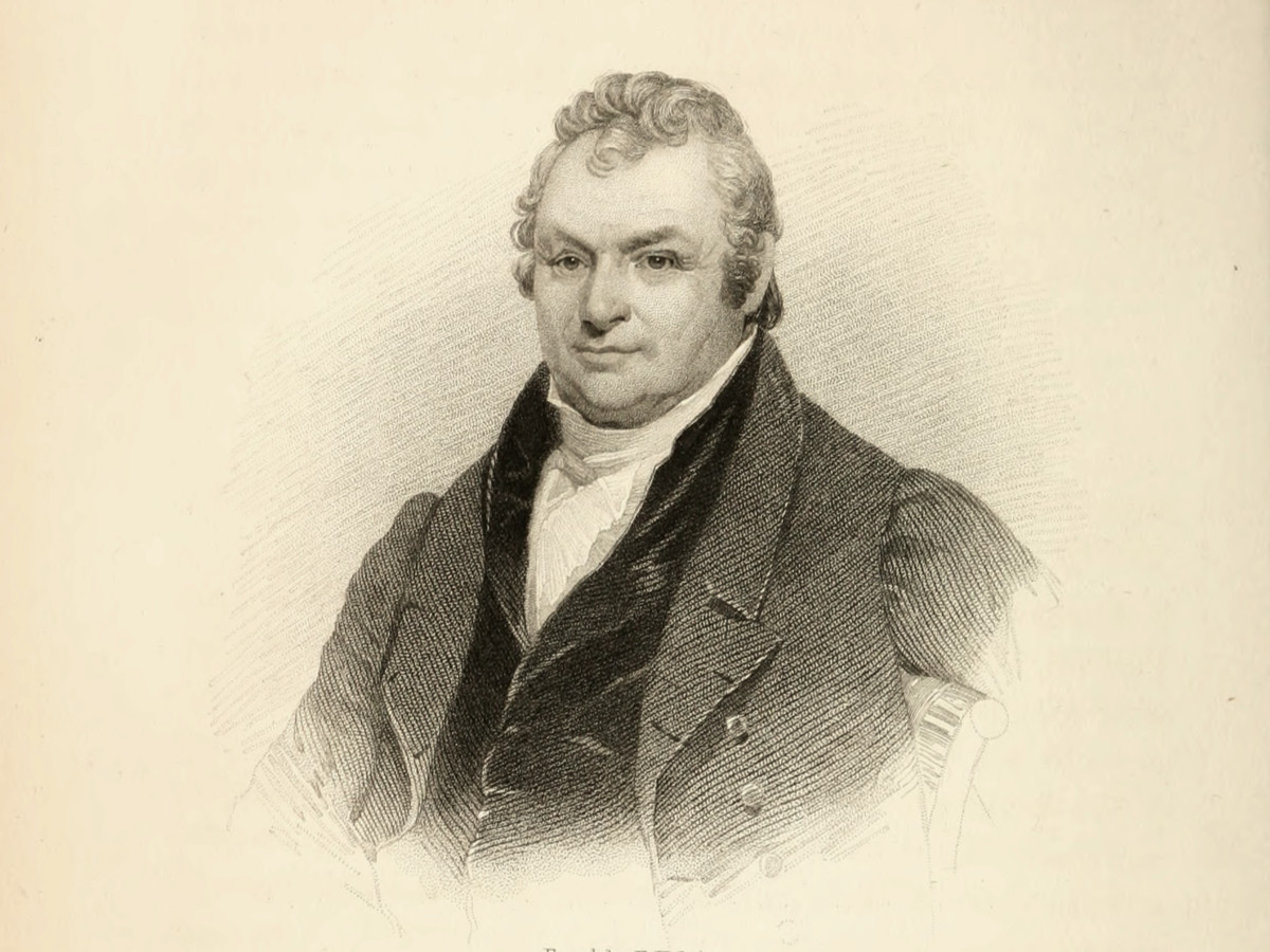
Sustained by a $75 supplemental appropriation, Geddes finished a hurried inspection of an interior route — in the course of which he encountered the Oneida and Seneca rivers and, he believed, a rare opportunity. Here, he reported, there would be no need to dig a canal, because those streams could be improved and made navigable to canal traffic. As he wrote the following January in a report to the state legislature, they comprised an “extensive piece of inland navigation which nature has almost finished to our hand.”
Geddes’ observation, while correct, was far ahead of his time. Such large-scale engineering was well beyond the reach of the early 19th century. With one notable exception — Tonawanda Creek near Buffalo — no natural streams would be integrated into the original Erie Canal. The rest of the distance would be covered by a hand-dug channel.
He did get many things right, including this: An inland route to Lake Erie was practical and perhaps the best option. Any route through Lake Ontario risked diverting commercial traffic to Canadian ports, he wrote, and quoted “a correspondent” to add that “an inland canal would always be safe in the event of a war with Great Britain.”
As if to prove his point, in June 1812 the United States declared war against its estranged mother country. Western New York and its Great Lakes coastline, from Buffalo to Sackets Harbor, became a major theater of the conflict.
Plans for the great western canal were put on hold. But important lessons were learned. During the war, not only was commercial lake traffic disrupted, the American military found out just how difficult and expensive it was to transport arms, ammunition, and other supplies to western New York. Existing roads were woefully inadequate. Improved transportation — such as a canal — was needed.
East meets west
After the war, as politicians in Albany squabbled and plotted, a consensus began to emerge around the need for an inland route to Lake Erie. In 1816 new survey teams were sent out, led by men who now had a better idea of what they were up against.
For reasons partly administrative, partly political, the proposed canal was divided into western, middle, and eastern sections. Geddes led the survey team for the western section, starting at the headwaters of Tonawanda Creek and heading east. The team charting the middle section, led by Benjamin Wright, began at Rome and headed west. The surveys met at the Seneca River, the boundary between the two sections.
Boundary — and now a barrier. Instead of being a “piece of inland navigation” generously furnished by nature, the wide river was simply in the way.
Walking on water
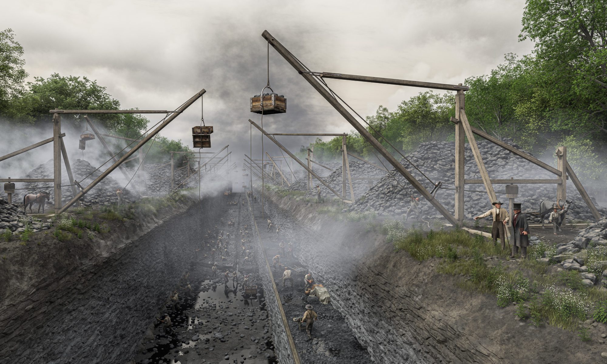
There were two ways to cross a stream that obstructed the canal’s path.
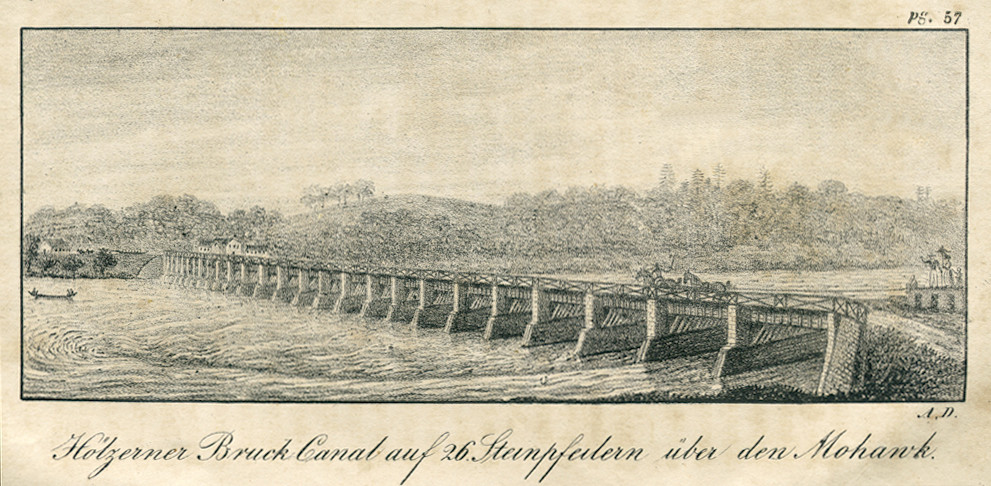
The first, and most common, was to construct an aqueduct. These were sometimes referred to as “water bridges” and were built in much the same way as road bridges. Some were built completely of stone, such as the aqueducts at Little Falls and Rochester. More often the abutments and piers were built of stone but the trunk, or canal channel, was made of wood planks. The aqueduct at Crescent, New York, which crossed the Mohawk River, was built this way. Using wood was less expensive and it worked well enough.
The second method was called a slackwater crossing. A dam was built across the stream, creating a pool of still or “slack” water. A narrow, wooden towpath bridge would then be built across the pool so animal teams could tow the boats across. The Schoharie Creek crossing at Fort Hunter was made this way, and this is how engineers originally planned to cross the Genesee River at Rochester. Guard locks were usually built on either side of the crossing to maintain the water level in the canal itself.
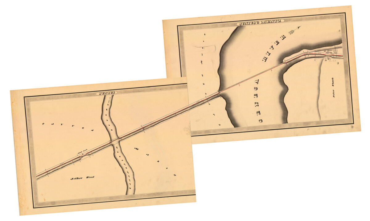
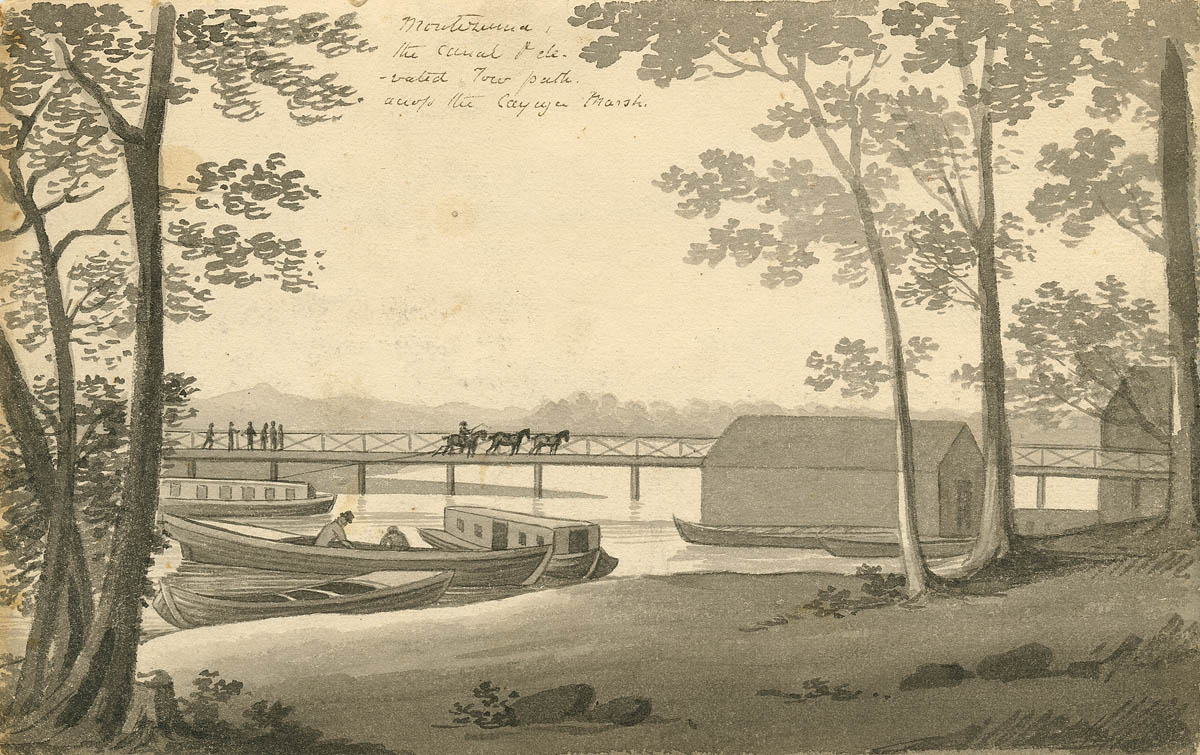
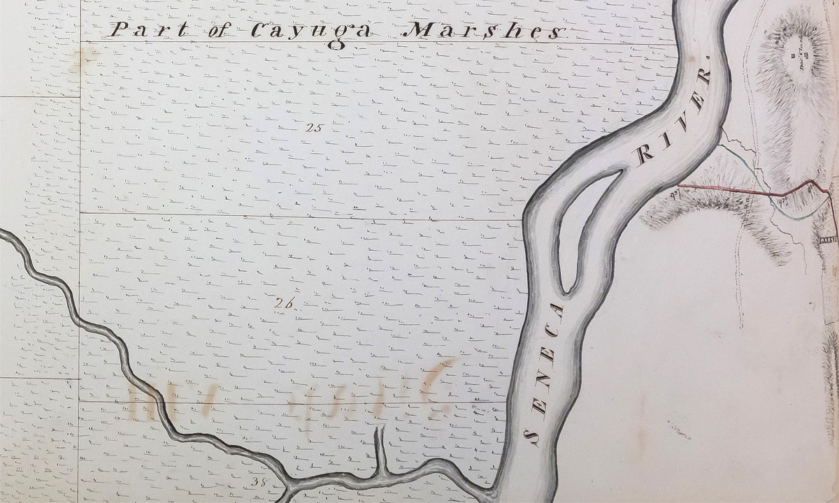
To the early canal planners, the Seneca River must have seemed the perfect candidate for a slackwater crossing. In their 1817 annual report, in which the canal commissioners described the previous year’s surveys, they reported that “[a] bridge 10 chains long, across the Seneca river, is all that remains to connect this [the western] section with that which includes the route between this river and Rome.” The bridge they described was a towpath bridge.
Ten chains equals 660 feet, and the commissioners may have considered this distance too great to be crossed by an aqueduct. Or they feared the muddy bottom of the river was too soft to support one. Or, simply, the slow-moving, shallow waters of the Seneca may not have seemed like much of an obstacle.
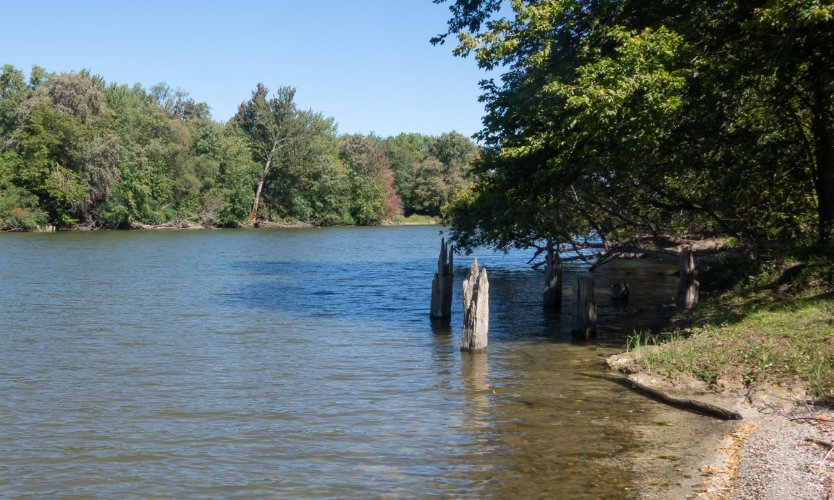
So contractors drove pilings and built the towpath bridge. Two, in fact: one over the Seneca River and a second over the nearby Canandaigua Outlet. The projected length of 660 feet for the Seneca bridge turned out to be 1,440 feet. For some reason — perhaps because of the slow current, or because it might complicate plans to drain the adjacent marsh — a dam was never constructed downstream of the crossing.
It was, it seems, a compromise. And soon enough it became apparent that it might not have been such a good idea.
The Seneca was a temperamental river whose depth fluctuated several feet over the course of the year. It could flood the adjacent marshlands one month and become too shallow to navigate the next. Even when it was at its “normal” depth, a channel had to be dredged parallel to the towpath bridge to accommodate the 3½-foot draft of the canal boats. This channel constantly silted over and groundings became so common that a lighter — a scow onto which canal boats could offload part of their freight — was stationed at the crossing to keep traffic moving. The crossing became the Achille’s Heel of the canal.
Full circle
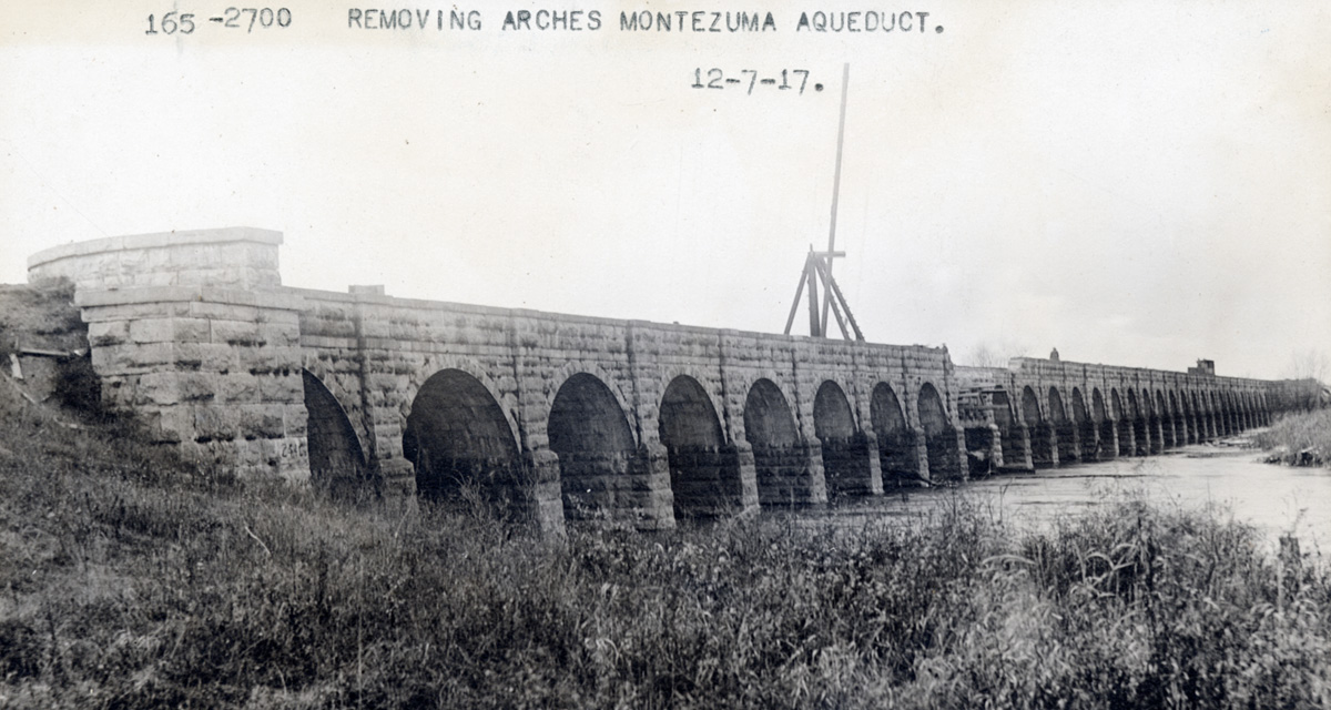
The solution was to construct an aqueduct. The Richmond Aqueduct, at 894 feet one of the longest structures on the canal, in 1856 replaced the slackwater crossing and carried the newly enlarged Erie Canal across the Seneca. At last, canawlers would no longer be subject to the whims of the river.
Sixty-one years later the aqueduct itself would be dismantled to make way for the New York State Barge Canal enlargement. By the early 20th century steam power, dynamite, and reinforced concrete had made possible James Geddes’ early 19th-century dream. The Seneca River and its neighbors were tamed, deepened, and turned into navigable streams, becoming at last that “extensive piece of inland navigation which nature has almost finished to our hand.”
Great article and images! Would you consider an embankment as a third way to cross a stream (e.g., the Great Embankment over Irondequoit Creek)?
Thanks! And you certainly could, especially considering that Geddes originally proposed an aqueduct at that location. Maybe a better third option would be a culvert. Many of these were built to cross creeks and small streams. At its base the Great Embankment included a culvert over Irondequoit Creek.