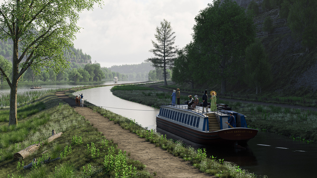
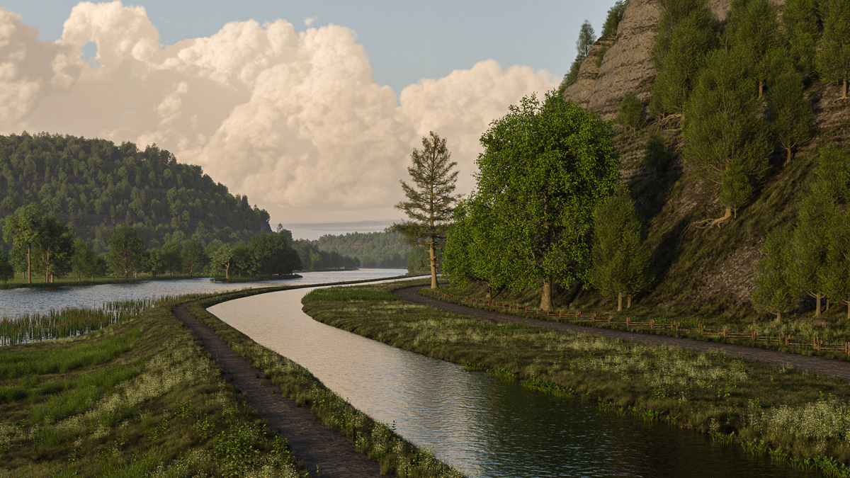
Passengers on the eastbound packet Stephen van Rensselaer take in the early-morning scenery along the Mohawk River in September 1825.
The Mohawk River scene set at the Noses is finally finished. Besides the packet boat passengers, it now includes the tandem rig of three horses and driver. Two Durham boats navigate along the river in the background.
The scene is set at 8:55 a.m. September 15, 1825. The canal will officially open within a few weeks, but already a collaboration of three packet lines provides passenger service between Schenectady and Lockport. Boats running in both directions depart Utica every evening. If my math is right the eastbound boat should be in the vicinity of the Noses by the following morning.
In those days the Mohawk Valley was considered to be one of the most scenic areas of the country. Harriet Martineau, the English sociologist, feminist, and writer who passed through twice in the 1830s – once by packet and once by rail – perhaps described it best in her book Society in America:
“The aspect of the valley was really beautiful last June. It must have made the Mohawk Indians heart-sore to part with it in its former quiet state; but now there is more beauty, as well as more life. There are farms, in every stage of advancement, with all the stir of life about them; and the still, green graveyard belonging to each, showing its white palings and tombstones on the hill-side, near at hand. Sometimes a small space in the orchard is railed in for this purpose. In a shallow reach of the river there was a line of cows wading through, to bury themselves in the luxuriant pasture of the islands in the midst of the Mohawk. In a deeper part, the chain ferry-boat slowly conveyed its passengers across. The soil of the valley is remarkably rich, and the trees and verdure unusually fine. The hanging oak-woods on the ridge were beautiful; and the knolls, tilled or untilled; and the little waterfalls trickling or leaping down, to join the rushing river. Little knots of houses were clustered about the locks and bridges of the canal; and here and there a village, with its white church conspicuous, spread away into the middle of the narrow valley. The green and white canal boats might be seen stealing along under the opposite ridge, or issuing from behind a clump of elms or birches, or gliding along a graceful aqueduct, with the diminished figures of the walking passengers seen moving along the bank. On the other hand, the rail-road skirted the base of the ridge, and the shanties of the Irish labourers, roofed with turf, and the smoke issuing from a barrel at one corner, were so grouped as to look picturesque, however little comfortable. In some of the narrowest passes of the valley, the high road, the rail-road, the canal, and the river, are all brought close together, and look as if they were trying which could escape first into a larger space.”
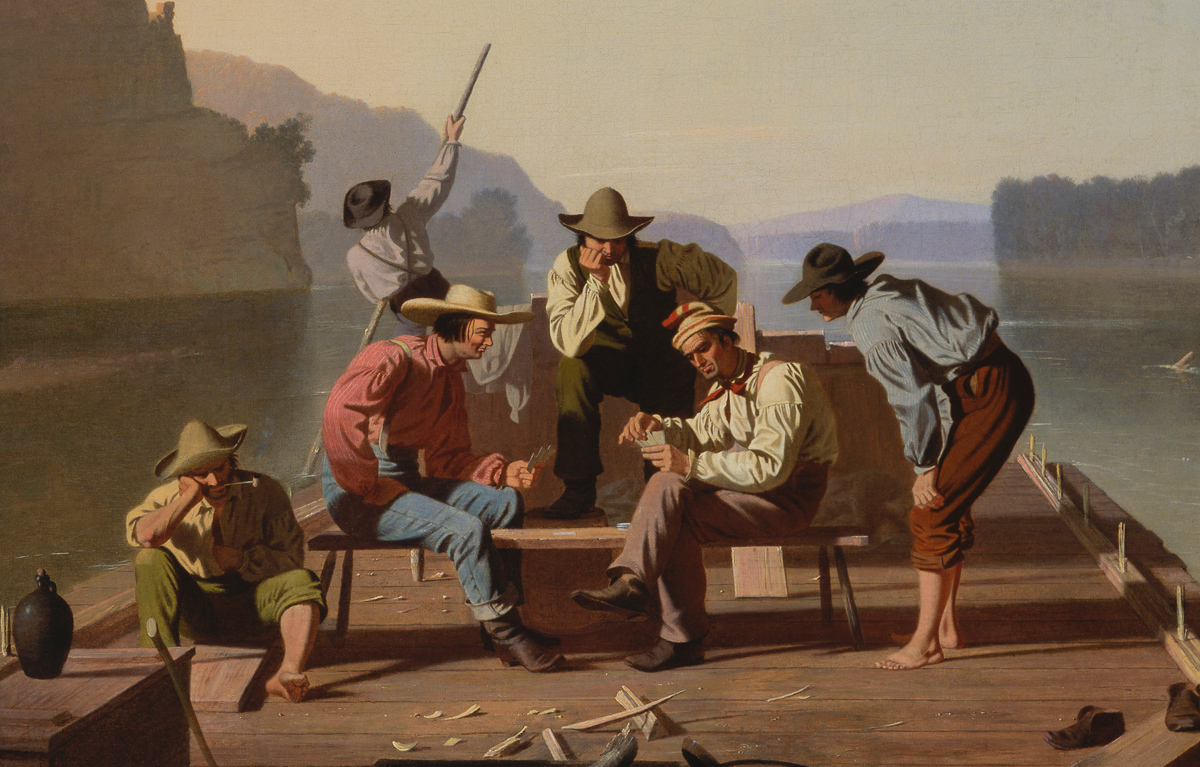
Early American painter George Caleb Bingham had a keen eye for detail and a precise brush to match, as this detail from “Raftsmen Playing Cards,” completed in 1847, shows. (St. Louis Art Museum via Wikimedia)
What to wear?
Adding human figures to a digital scene is one thing. Providing them with accurate historical clothing is something else.
Plenty of online sources pop up when you search for early 19th century clothing, complete with fashion plates and examples of clothing worn by the upper classes. But you need to go deeper to find information about everyday clothing worn by working people.
Among the best sources of visual information are early American genre painters such as William Sydney Mount, George Caleb Bingham, and Francis William Edmonds. Of these I’m most familiar with Bingham, who lived and painted on the Missouri frontier in the early 1800s. At that time the western New York frontier was just as raw, so his depictions of flatboat men and farmers apply as well to the early Erie Canal.
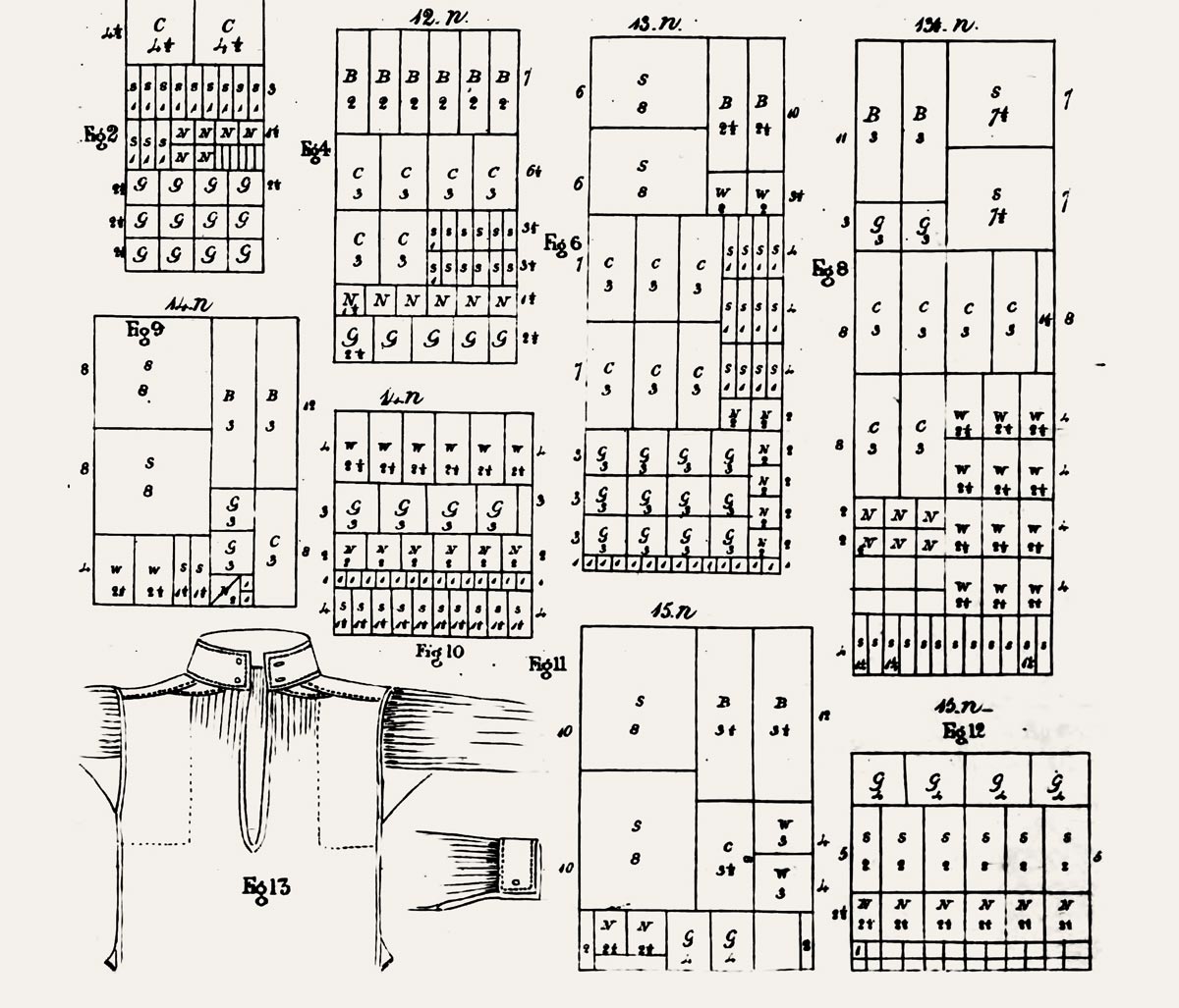
Waste not, want not: Diagrams from “The Workwoman’s Guide” demonstrate how to use every square inch of fabric when cutting out parts for men’s work shirts. (Oxford University via Google Books)
But while paintings can provide context and color, you still need patterns. Several 19th-century tailor’s guides are available in digital format, and I’ve already mentioned how useful they can be when creating upscale digital clothing. For working-class folks, there is The Workwoman’s Guide, published in 1840.
Its full title: The Workwoman’s Guide, Containing Instructions to the Inexperienced in Cutting Out and Completing Those Articles of Wearing Apparel, &c., which are Usually Made at Home: Also, Explanations on Upholstery, Straw-platting, Bonnet-making, Knitting, &c. A mouthful, to be sure, but seriously: everything you might want to know about running an early 19th-century household is in this book.
Besides historical sources, these recent references have been helpful:
Pattern Cutting for Men’s Costume, by Elizabeth Friendship (Bloomsbury, 2008)
The Mountain Man’s Sketch Book, Volume One, by James Austin Hanson and Kathryn J. Wilson (The Fur Press, 1976)
Making Working Women’s Costume, by Elizabeth Friendship (The Crowood Press, 2018)
Regency Women’s Dress, by Cassidy Percoco (Batsford, 2015)
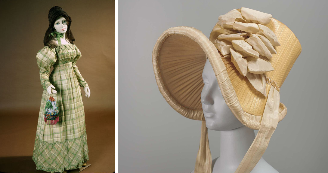
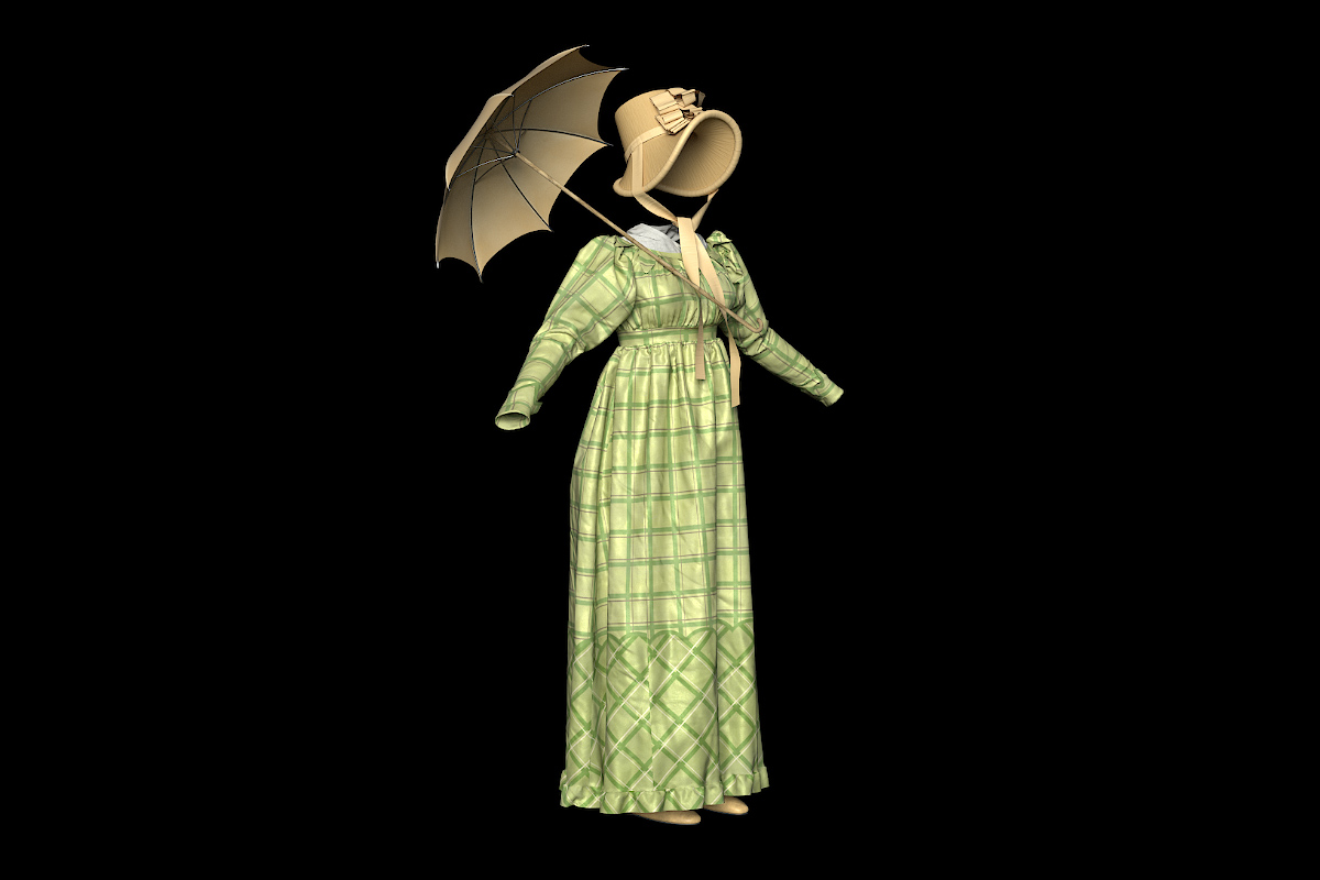
Sources for a fashionable young packet passenger include this plaid gingham gown (left) and a straw bonnet imported from France, both dating from the early 19th century. (Gown: Old Sturbridge Village, accession number 26.33.63; bonnet: Museum of Fine Arts, Boston; The Elizabeth Day McCormick Collection, accession number 44.189)
Finally, thousands of historical artifacts – many stored out of sight in the permanent collections of museums – are now virtually accessible in online databases. Though the collections are biased toward middle- and upper-class objects, they still provide a fascinating (and searchable) real-world check on the things you may find in paintings and old pattern books.
I use a program called Marvelous Designer to create natural-looking clothing for my scenes. It is a simplified version of more powerful applications used by professional clothing designers, and is used by digital artists who create animated films and video games. This project would not be possible without this remarkable tool.
Patterns for the young woman’s gown are created and stitched together in Marvelous Designer, which then handles the cloth simulations and drapes the clothing on the posed model. Marvelous Designer is capable of simulating specific types of fabrics, from heavy canvas to light gauze. In this case the fabric is set to simulate silk taffeta, which was used for the original gown.
The workflow is simple: You draw the patterns and stitch them together, fitting everything to a 3D human model. Designer uses simulated gravity to make the clothing drape and fold naturally. Short animations move the models into the poses needed for the scene.
Here are a couple of examples of clothing created for packet boat passengers. (Packet boat travel was very democratic, with people of all classes crowded together on the boats.)
Digital clothing created in Marvelous Designer is transferred to Substance Painter for shading, which gives the fabric its surface texture and color.
For the first, a well-to-do young woman from back East, two artifacts seemed to fit the bill: a gown from Old Sturbridge Village, and a bonnet from the Museum of Fine Arts in Boston.
After the patterns are cut out and and assembled in Marvelous Designer, the finished clothing is moved into Substance Painter, where patterns and colors are applied, as well as a texture to mimic the shiny surface of silk.
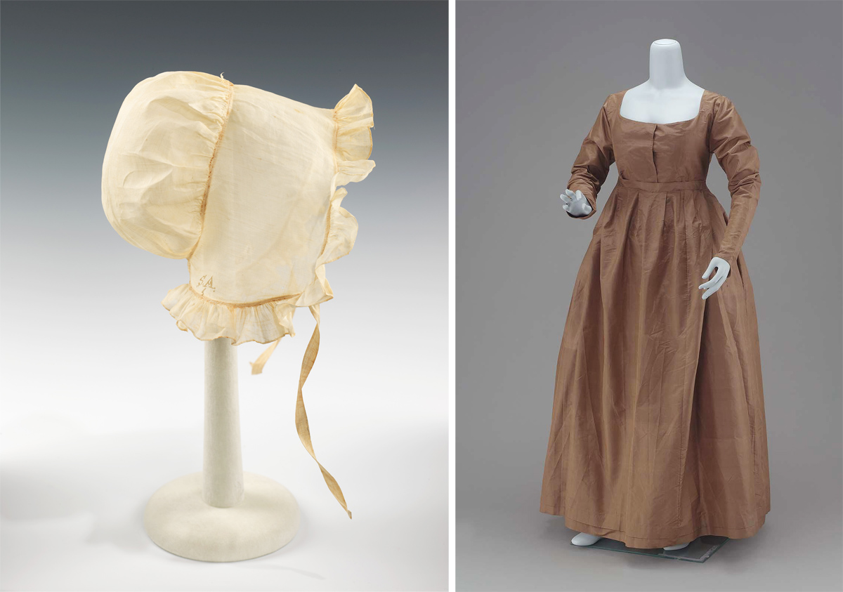
References for a Quaker woman’s clothing include this poke bonnet (left) and taffeta gown, both dating from the early 19th century. (Bonnet: Brooklyn Museum Costume Collection at The Metropolitan Museum of Art; gift of the Brooklyn Museum, 2009; gift of Grace Coleman, 1927; accession number 2009.300.2689); Gown: Museum of Fine Arts, Boston; gift of Mrs. Grosvenor Calkins, accession number 52.1769)
Western New York was home to several early Quaker settlements, so it also seemed appropriate to include a Quaker couple.
The woman’s clothing is based on objects from the Museum of Fine Arts and the Metropolitan Museum of Art in New York. The man’s clothing is based on a variety of sources including Friendship’s Pattern Cutting for Men’s Costume.
A test rendering of our Quaker couple, ready to be placed on the deck of the packet boat.
While the Quakers espoused plain dress, that meant simple designs, not inexpensive fabrics. The woman’s dress is again made of silk taffeta. The man’s shirt is cotton. Wool trousers and the ubiquitous straw hat complete his outfit.
These simple garments have the advantage of reusability. With small changes they can be recycled for use in other scenes, or even for different figures in the same scene.
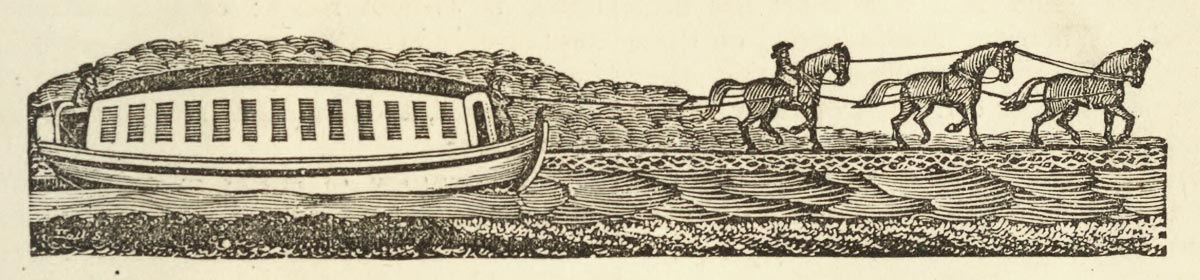
A tandem team of three horses tows a passenger packet in this detail from “View on the Erie Canal” by John William Hill. The 1829 painting is one of the finer early depictions of the canal. (I. N. Phelps Stokes Collection of American Historical Prints, New York Public Library)
In 1820 a new kind of watercraft appeared on completed sections of the Erie Canal.
Named after the packet ships that sailed the North Atlantic between Europe and the eastern seaboard, the new Erie Canal passenger boats were towed by two or three horses at a brisk clip of 4 to 6 miles per hour. Even before the canal was finished, packet lines springing up along completed sections boasted of making the trip between Schenectady and Utica in 24 hours, and from Utica to Rochester in two days. A far cry, indeed, from the days or weeks previously required when traveling by stage over wretched roads.
Travelers had never experienced anything quite like it: The quiet, smooth experience of floating across the landscape was completely new.
Woodcut of a packet boat, published in “One Hundred Years’ Progress of the United States,” 1871. (Internet Archive)
In Erie Water West, Ronald E. Shaw quotes a Rochester pioneer about to take his first journey by packet: “Commending my soul to God, and asking his defense from danger, I stepped on board the canal boat, and was soon flying towards Utica.”
During its heyday, packet travel became commonplace and the Erie Canal a thoroughfare not only for local inhabitants but also for thousands of immigrants making their way to Buffalo and on to the upper Midwest. But the packet era did not last long. By the 1850s, once the railroads began to carry most long-distance passenger traffic, it was over.
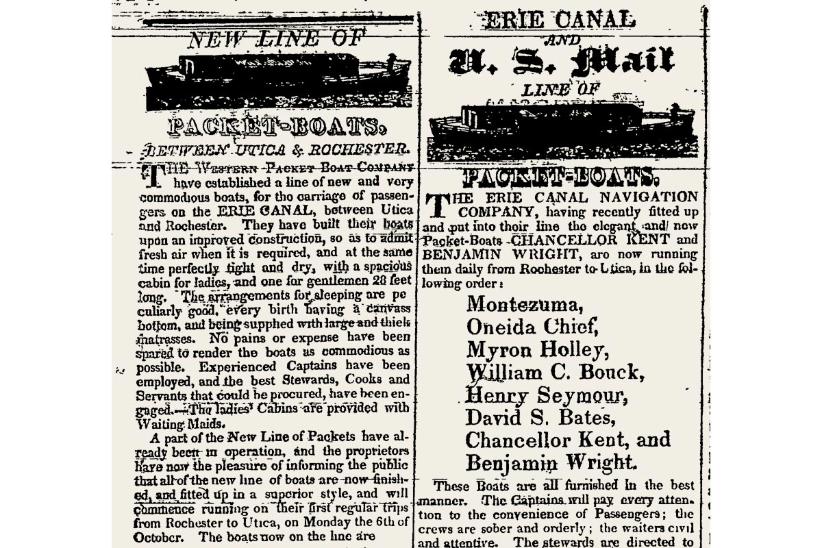
Notices from competing packet boat lines run side by side in the Dec. 3, 1823 edition of the Wayne County Sentinel. (NYS Historic Newspapers)
Near the end, a humorous magazine sketch by Harriet Beecher Stowe noted just how prosaic packet travel had become:
“. . . in a canal boat there is no power, no mystery, no danger; one cannot blow up, one cannot be drowned, unless by some special effort: one sees clearly all there is in the case – a horse, a rope, and a muddy strip of water – and that is all.”
Even so, two hundred years later romantic images of packet boats linger in our collective memory and often come to mind when the Erie Canal is mentioned.
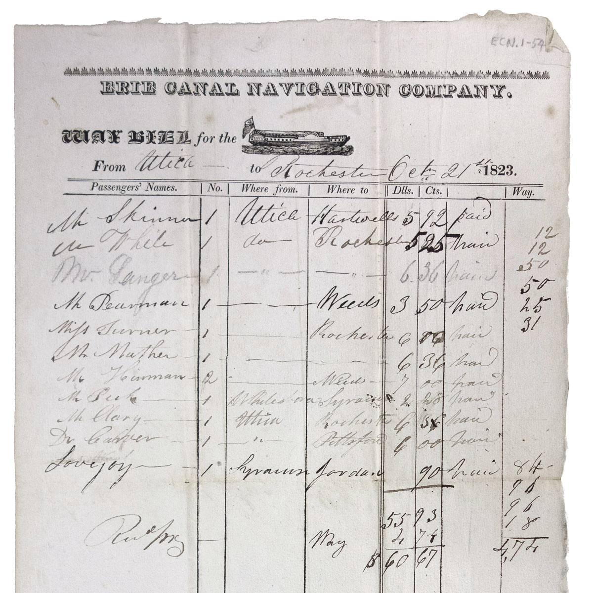
Waybill for the William C. Bouck, dated Oct. 21, 1823, lists 12 passengers and total receipts of $60.67. (Oneida County Historical Society)
Building our packet
There are no photographs of early packet boats, of course, nor anything resembling construction plans. We do have many woodcuts and engravings of varying quality and detail, as well as first-person accounts by packet passengers. Most accounts dwell on the experience of packet boat travel and the variety of the passing landscape. But they don’t say much about the packets themselves, perhaps because the boats were so ubiquitous that the writers felt no need to describe them. An exception is a detailed account written by “A Traveller” and published in The Freeman’s Journal of Cooperstown in August 1821:
“There are two packet-boats, the Montezuma and Oneida Chief, owned by the Erie Canal Navigation Company (incorporated). These boats are 77 feet in length and 13 in width; are each navigated by 7 hands, viz. a captain, 2 helmsmen, 1 bowsman, a steward, a cabin-boy, and cook . . . The forward cabin is used for lodging, and is handsomely finished off with 12 births [sic], each having a good bed or mattress, and every suitable accommodation. Next, and in the centre, is a dining cabin, 18 feet by 13, where 25 passengers can conveniently be seated at table; and on the sides of this cabin are settees; to that, with these and mattresses, good lodgings for up to 30 passengers can be had. More than this number cannot be well accommodated in their boats. Next to this cabin is a gangway and bar, which are rented to the steward at $250 for the season; at which bar, passengers are furnished with as good refreshments as can be had on board our steam boats, and at as cheap a rate. Next, and back of this, is a kitchen, with all the cooking apparatus, and lodgings for the crew.”
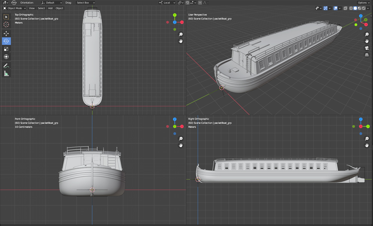
Quad view of the packet boat model in Blender.
Our traveler doesn’t mention the driver, who would have ridden the last horse in the two- or three-horse tandem team that provided the motive power for the packet. Perhaps he wasn’t counted as a member of the crew, as drivers and teams were switched every few miles along the route.
My packet boat model will represent the Stephen van Rensselaer, which was operated by the Utica & Schenectady Packet Boat Company on a daily schedule between the two cities. (In Utica, passengers could catch an Erie Canal Navigation Company packet headed for Rochester.) For the dimensions and design I’m relying on packet boat plans drawn by Robert E. Hager, an amateur historian and extraordinary draftsman whose drawings are preserved at the Chittenango Landing Canal Boat Museum. Our packet is 70 feet in length and 14 wide.
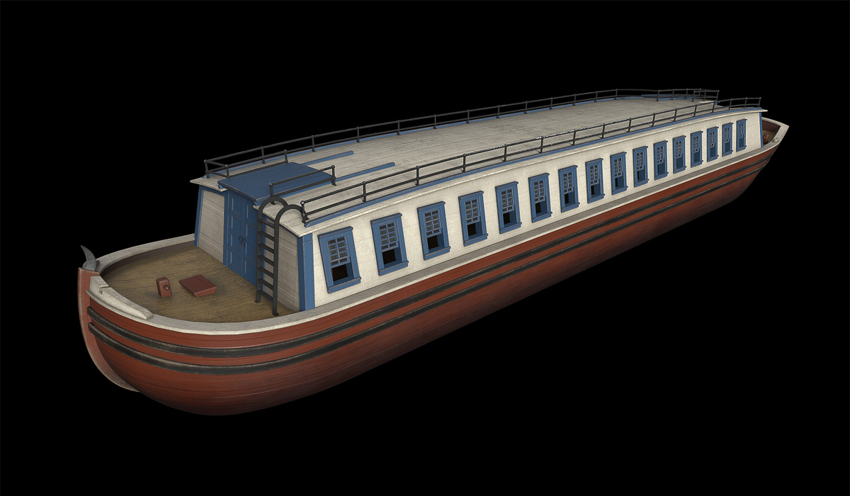
Packet boat surface colors and textures are added in Substance Painter.
Contemporary sources often describe packet boats as brightly painted without being very specific. Woodcuts and engravings are no help, naturally, but John William Hill’s watercolor View of the Erie Canal gives us some subtle hints, as do some everyday early 19th-century artifacts. Many early packets were given patriotic names (or like ours, named after one of the canal commissioners), so I’ve chosen a combination of red, white, and blue for the Stephen van Rensselaer.
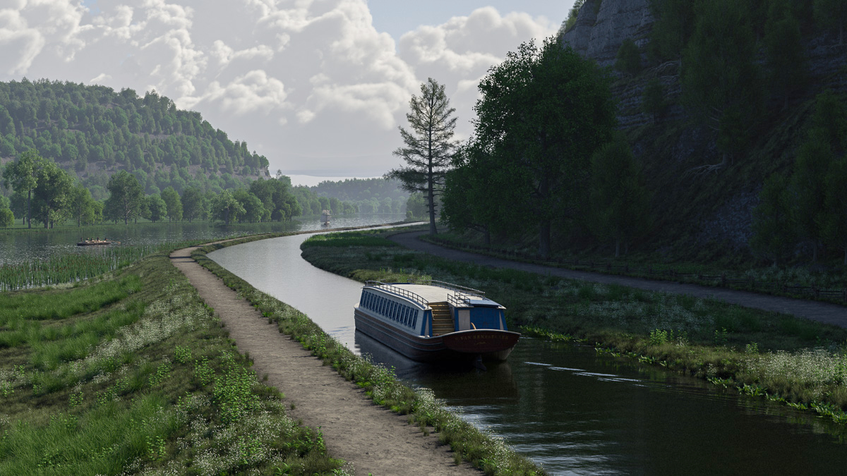
The finished packet model is placed in the scene for a test rendering.
As a test the new model is placed in the scene and rendered, along with two versions of the Durham boat model on the distant Mohawk River. Still much work to do here: passengers, a steersman, the team of horses and driver, and other details need to be added. But the picture is starting to come together.
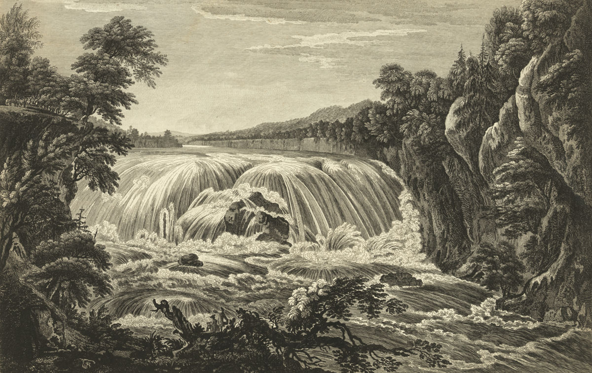
Cohoes Falls, on the Mohawk River above its junction with the Hudson, as depicted in an early engraving. The 90-foot cataract remained a serious impediment to western navigation until it was finally bypassed by the Erie Canal in 1825. (Library of Congress)
Before the Erie Canal, there was the Western Inland Lock Navigation Company.
A private corporation formed to improve the waterways of central New York, the company was chartered by the state in 1792 to open routes from the Hudson River to points west.
The idea was not to build a single canal from the Hudson to Lake Erie, or even to Lake Ontario. At the time, that would have been considered little short of madness. Instead, short canals would divert existing rivers around waterfalls and link them with other rivers and creeks, making them navigable to large boats.
The Mohawk River would be opened by removing boulders and building wing dams to eliminate its numerous rifts, or shallow rapids. Wood Creek, the timber-choked, serpentine link to Oneida Lake, would be cleared, straightened, and connected to the Mohawk. Further work on the Oswego, Seneca, and Onondaga (now Oneida) rivers would extend navigation to Lake Ontario and the Finger Lakes.
It was an ambitious plan. Legislators, recognizing this, granted the corporation a 15-year time frame to accomplish it.
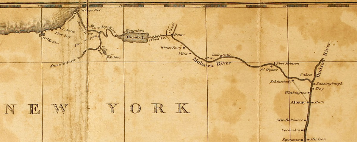
This map, published in Christian Schultz’s 1810 “Travelers on an Inland Voyage,” depicts the water routes improved by the Western Inland Lock Navigation Company. Though it failed to open a navigable route to Lake Ontario (upper left), the company opened the Seneca River and other rivers further west (not shown) to large-boat navigation into the Finger Lakes region of central New York. (University of Pittsburgh Library System via Internet Archive)
But the planner’s reach far exceeded their – and their young country’s – grasp. The vast scale of the project, with work sites scattered across thousands of square miles of wilderness, combined with primitive technology and poor management, doomed it from the start.
The planners’ lack of practical experience didn’t help.
Elkanah Watson, an early and vocal canal proponent and one of the directors of the corporation, made no secret of this a few years later when he described “borrowing” ideas from a similar project on the Potomac River:
“Indeed we were so extremely deficient in a knowledge of the science of constructing locks and canals, that we found it expedient to send a committee of respectable mechanics, to examine the imperfect works then constructing on the Potowmac, for the purpose of gaining information,—we had no other resource but from books.”
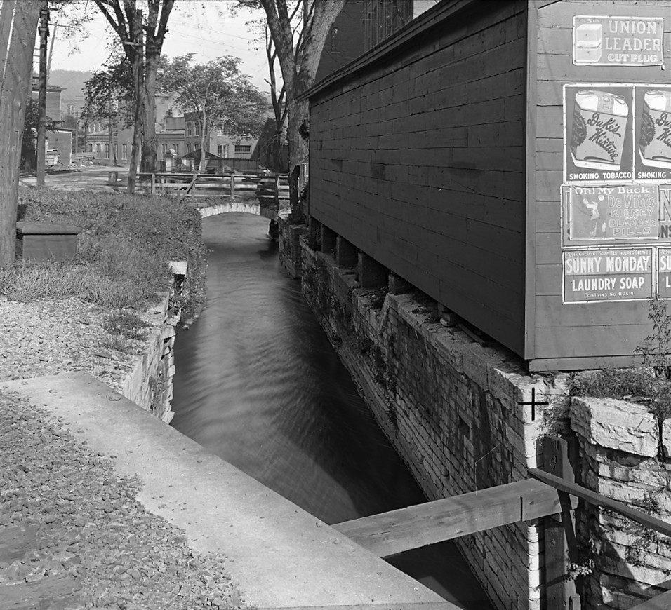
A lock constructed by the Western Inland Lock Navigation Company in Little Falls, as it appeared in 1911. (New York State Archives)
The Western Inland Lock Navigation Company operated until 1820, when it was purchased by the state and absorbed into the Erie Canal. Financially, it had barely survived and is considered by many to be a failure. Two of its primary objectives – opening the Oswego River to Lake Ontario and bypassing Cohoes Falls near Albany – were never seriously addressed.
Even so, much had been accomplished. In 1818, Watson wrote from Seneca Falls:
“In 1791, I came in a batteau from Schenectady to this place. . . . At that period they could only transport from one and a half, to two tons, in a flat boat, at an expense of from seventy-five to one hundred dollars a ton, from Schenectady to this place.
“By the completion of the works along the Mohawk River, Wood creek, and down Onondaga and up Seneca Rivers, in 1796, boats of a different construction, carrying from fifteen to sixteen tons, were introduced, and the price of transportation was reduced to about thirty-two dollars per ton, from Schenectady to the Seneca falls, and half that sum on returned cargoes.”
Later planners of the Erie Canal learned three important lessons from the failure of the Western Inland Lock Navigation Company. First, the economic benefit of constructing a water route from the eastern seaboard to the interior could potentially far outweigh the cost. Second, the idea of digging an artificial channel across New York state – crazy as that seemed – was the only way this could be accomplished. Finally, the scale of such a project exceeded the capacity of private enterprise and meant it would have to be organized by the state.
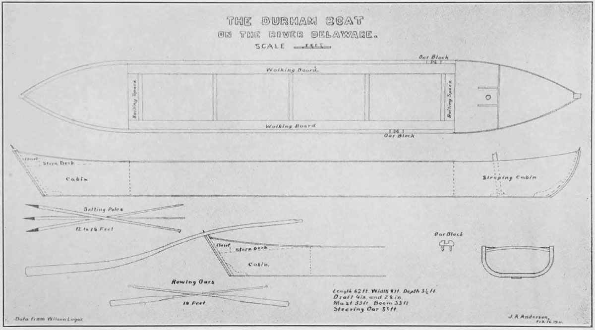
This drawing of a Delaware River Durham boat, made by John Alexander Anderson and published in “Navigation on the Upper Delaware” in 1913, was based on the recollections of Wilson Lugar, who owned and operated a Durham boat in the 1860s. (Library of Congress)
The elusive Durham
The “boats of a different construction” that Watson mentioned were almost certainly Durham boats. These narrow craft, about 60 feet long and pointed on both ends, had been used since the early 18th century to haul grain and iron ore on the Delaware River. Fully loaded, a Durham boat could carry from 15 to 20 tons of cargo, and its shallow draft and flat bottom made it perfect for navigation on swift-flowing rivers.
Famously, Durham boats were used by George Washington to ferry his troops across the Delaware on their way to Trenton, and victory, in 1776.
By the late 18th century, Durham boats were plying the Susquehanna and Mohawk rivers in Pennsylvania and New York, the St. Lawrence River in Canada, and even the Fox River in modern-day Wisconsin.
Despite regional variations, the boats all shared the same basic design. In deep water they could be powered by oars or sails – though the lack of a keel made that last bit tricky. In shallow water they were driven forward by men who walked the length of the boat – two or three on each side – while bracing themselves against long, iron-tipped poles set into the riverbed.
In 1888, historians in Wisconsin interviewed Alexis Clermont, who had been born in 1808 and, in his early 20s, joined the crew of a Durham boat:
“There were generally seven men of us – six poles and a steersman; sometimes there was a cook, but the usual custom was to have a cook for a fleet of three boats. Traders were in the habit of running such a fleet; for when we came to rapids, the three crews together made up a crew big enough to take the boats and their lading through with ease. Each boat had a captain who was steersman. Durham boats were from sixty to seventy feet long, and carried from twelve to sixteen tons.”
Similar accounts are scattered throughout the historical record. We know that the boats often set out in fleets of 25 or more; in all probability, thousands of Durham boats were in service at any one time, hauling raw materials like potash, grain, and iron ore downstream, and finished goods back into the interior. For good reason, the Durham boat has been called the semi-tractor trailer of early America.
But the commencement of the canal era, and later the arrival of the railroad, quickly made the Durham boat obsolete. This once-ubiquitous watercraft was gone by the Civil War, without leaving a trace.
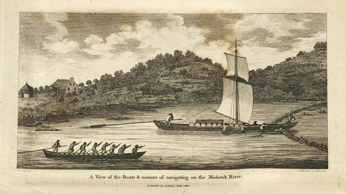
A Durham boat (right) navigates the narrow passage through a Mohawk River wing dam in this 1810 view, published in “Travels on an Inland Voyage” by Christian Schultz. A bateau powered by a crew using set poles follows. (New York State Library)
For a while, though, Mohawk River Durham boats and Erie Canal boats would have co-existed, with Durham boats carrying on as before on the river while newfangled packets, freighters and line boats crowded into the new canal. This would have been particularly true in 1825, the date of the scene I’m working on, when the canal was not yet open to through traffic. So I’d really like to include a Durham boat or two on the river.
But what did they look like? How were they built? We are left with a few fragmentary descriptions and a couple of contemporary images. The best, created by New York engraver Peter Maverick and reproduced in Christian Schultz’s “Travels on an Inland Voyage,” shows a crew, waist-deep in the Mohawk River, struggling to guide their boat through the narrow opening of a wing dam.
That 1810 engraving might have been our last eyewitness view of a Mohawk River Durham boat.
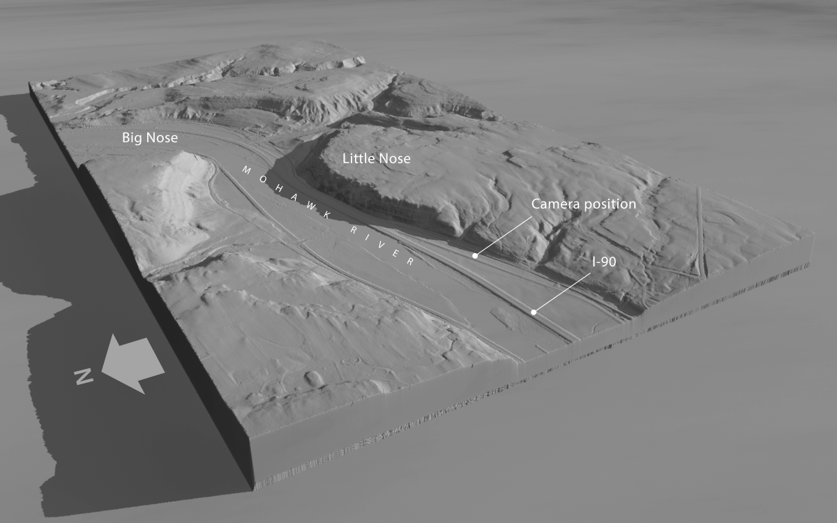
This high-altitude, oblique rendering of area around the Noses was created in Terragen with digital elevation data available from New York state. The view faces southeast and shows the course of the Mohawk River, the New York State Thruway (I-90), and the location of the ground-level camera that will capture our scene.
The water gap at the Noses has been a vital communications corridor for millennia. Carved long ago by the post-glacial Iromohawk River as it drained Lake Iroquois, an enormous meltwater reservoir formed by the retreating ice sheet, the gap was viewed as the work of Providence by early proponents of the Erie Canal. Besides providing a natural pathway for the canal, it eventually accommodated railroads, highways, and the New York State Thruway.
As a result the valley has been heavily altered. Aside from the Thruway, which was built in the 1950s, construction in the early 1900s rechanneled and deepened the Mohawk to carry Barge Canal traffic.
Our challenge will be to visualize how the valley would have appeared to early canal travelers – to turn back the clock two centuries.
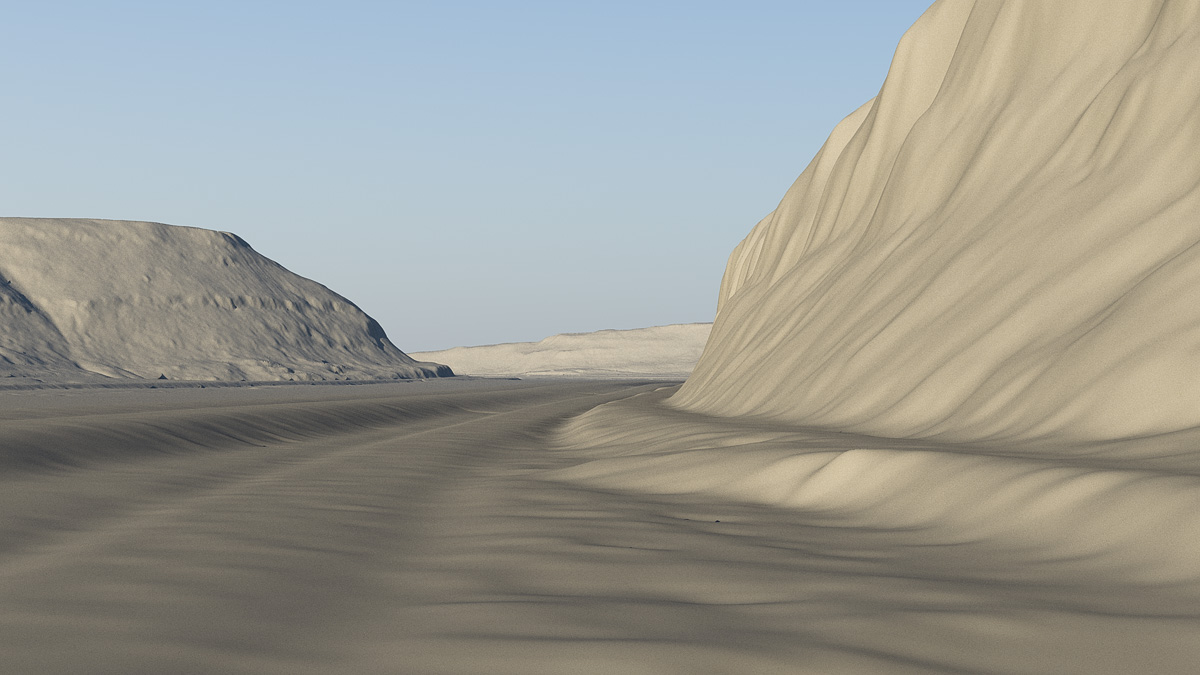
This is the view through the ground-level camera, facing roughly east. The road embankments for I-90 (left) and Route 5S (right) are clearly visible.
From the ground up
Fortunately, we don’t have to start from scratch. Digital elevation data of the area is freely available from the New York State Geographic Information Systems website. The data, gathered by satellites that precisely map the height of the earth’s surface, can be imported into Terragen and rendered as a three-dimensional scene. The resolution is fine enough to allow us to position the camera at ground level.
But even so, details of the cliffs and ground are indistinct. And modern artifacts, like the Thruway embankments, will have to go.
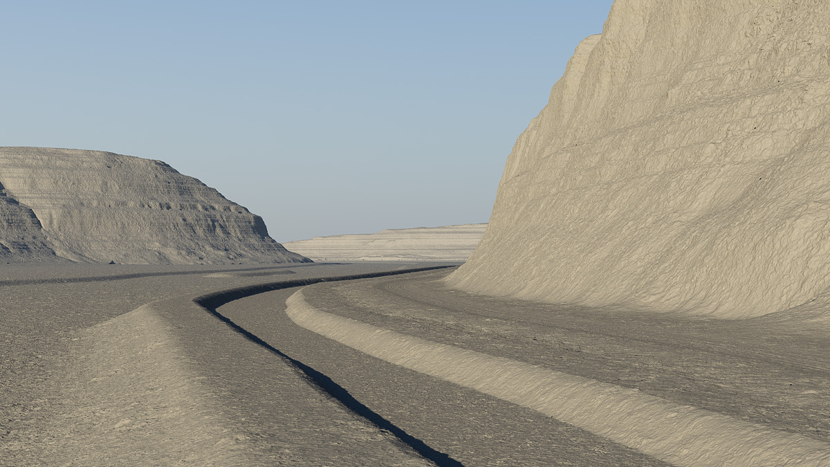
In Terragen, the terrain is edited to remove the road embankments and to add the berms and bed for the Erie Canal. The Mohawk River has been returned to its pre-20th century location.
In Terragen, the vertical displacements of the valley floor are edited to remove those artifacts. Then, using Holmes Hutchinson’s 1833 survey maps as a guide, the bed, berm, and towpath of the canal are added, as well as a narrow road hugging the base of the cliff. The Mohawk channel is returned to its rightful place.
High-frequency details in the cliffs and ground surface are also restored.
The ground and cliffs are shaded, and foliage and water surfaces are added, to complete the terrain.
Next, topsoil, road, towpath and cliffs are shaded. Water surfaces are placed for the river and canal. Native ground foliage and tree species are created – grass, sedges, cattails, white pine, cedar, cottonwood, hickory, and others – and distributed throughout the scene. Some towering cumulus clouds add a little drama.
Aside from the inevitable tweaks and refinements, the terrain is finished. The next steps will be to create models of an Erie Canal packet boat, Durham boats to sail on the river, and crews and passengers.
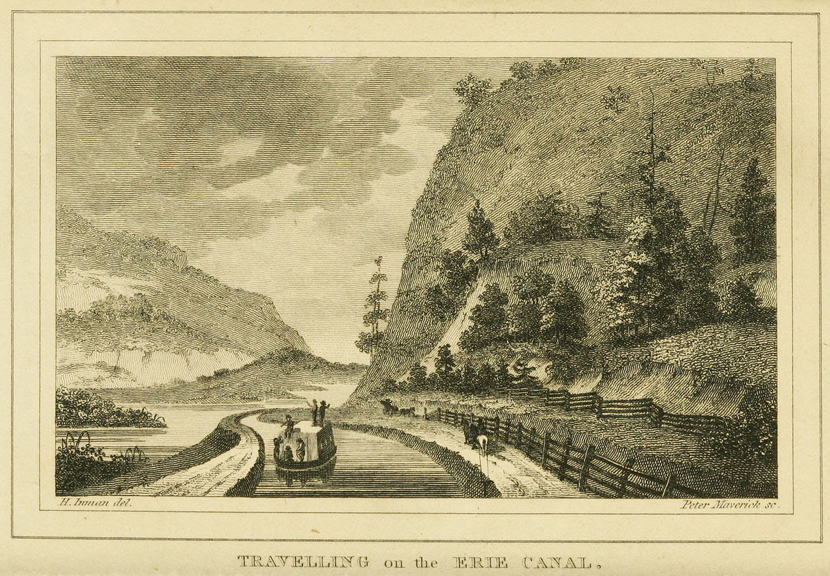
An Erie Canal packet boat passes the Noses in this view, published in the 1825 edition of “The Northern Traveller” by Theodore Dwight. The landscape is rendered accurately; however, the towpath should be on the opposite side of the canal. Henry Inman, the artist (designated “del” here, for “delineator”) was an early 19th-century portrait and landscape painter. Peter Maverick, the engraver (“sc” for “sculpsit”), is also remembered as one of the first lithographers in the United States. (Library of Congress)
The subject of the next Erie Canal scene will provide a welcome change of pace. Instead of the scarred and blasted landscape of the Deep Cut, we’ll go to a place where the canal engineers accommodated nature, where the canal’s gentle curves paralleled the Mohawk River as both made their way toward Albany and the Hudson River.
The place is known as The Noses, named for two cliffs that frame a narrow gap in the hills. The Mohawk flows between them as it crosses the Appalachian ridge, forming the only east-west water route that breaks through that mountain barrier over its entire extent from Maine to northern Alabama. It is the key geological feature that made the Erie Canal possible in the first place.
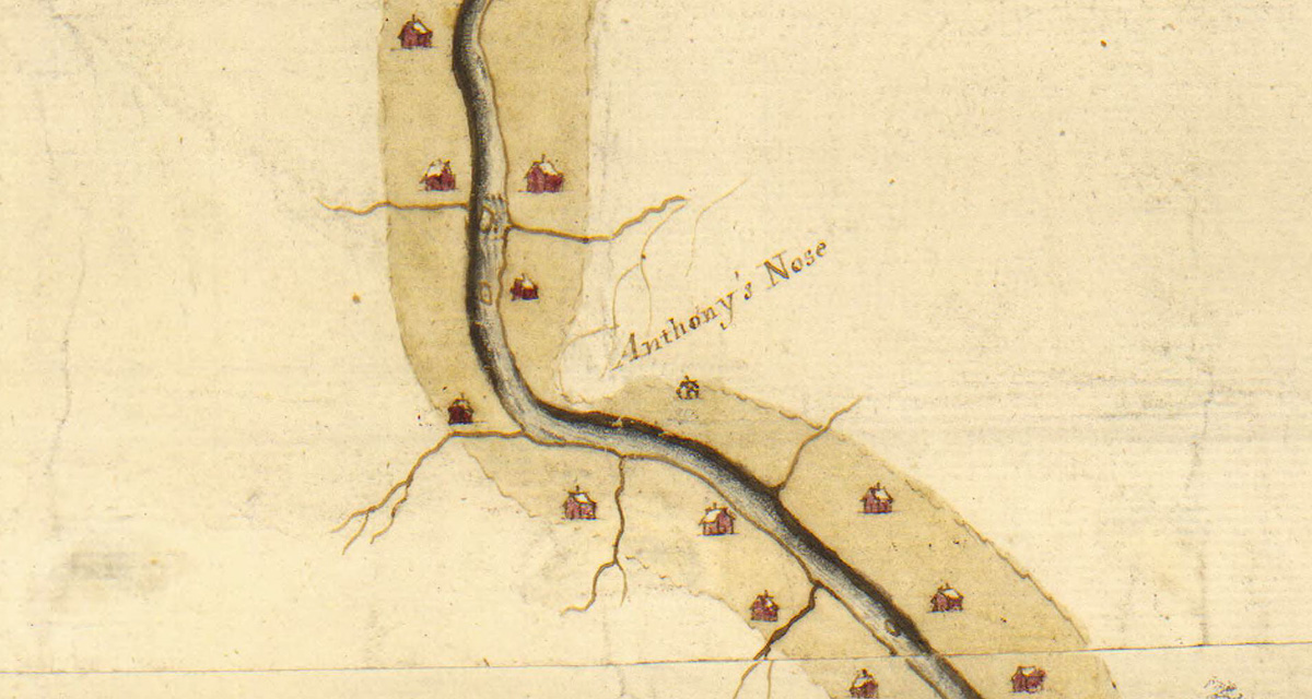
Anthony’s Nose is included as a distinctive landmark in this 1756 map of the Mohawk River. (William L. Clements Library/University of Michigan)
The Noses themselves are landmarks with references dating back to the colonial era. Back then, the larger cliff was known as “Anthony’s Nose.”
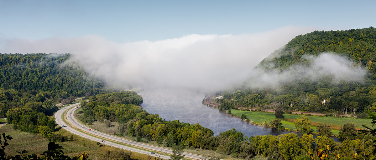
Anthony’s Nose, on the north side of the Mohawk, is today simply called “Big Nose.” Facing it across the way, on the south side, is Little Nose. The gap in between is an historic line of communication, and after the canal was built the railroad soon followed. Today, the New York State Thruway (Interstate 90) takes the same route.
A view of The Noses as they appear today, looking west. The New York State Thruway passes below. To its left, visible through the trees, is State Route 5S, which closely follows the path of the old Erie Canal. Today, the “canalized” Mohawk River carries Erie Canal boat traffic. (Photograph copyright Philip Scalia 2016)
A children’s book published in 1852, Marco Paul’s Voyages and Travels: Erie Canal, describes a trip through the gap by rail:
“For there is a place here called the Pass of the Mohawk. It is where the river flows through a narrow passage in the mountains, with extensive ledges of rock and lofty cliffs on either hand. As the train of cars advanced up this defile, Forester and Marco perceived that the mountainous ranges approached nearer and nearer, until the river, the turnpike, the railroad and the canal were crowded close together and Marco could look down upon them from the window of the car, running side by side, and hemmed in on either hand by precipices of ragged rocks.”
This map of Erie Canal at the Noses was drawn in 1851 by David Vaughan. It shows the original Erie Canal as well as proposed changes for the First Enlargement. The map is upside-down, with south pointing toward the top edge. (New York State Archives)A drawing from David Vaughan’s 1851 map matches the view captured by photographer Philip Scalia, above. Areas that today are wooded were clearcut for agriculture in the 19th century. (New York State Archives)
Historical references
There is a wealth of visual information about this area, dating from an 1811 survey map drawn by Benjamin Wright, who later became the Erie Canal’s chief engineer. We also have a spectacular map created by draftsman David Vaughan in 1851. Vaughan’s map is useful because it features detailed drawings – one of his hallmarks – that provide clues to the state of the landscape. Today the area is mostly covered with second-growth woods. But in the early 19th century much of it would have been cleared for farming.
Even more valuable are the so-called Holmes Hutchinson maps of the Original Erie. These were the result of a survey of New York’s canal system commissioned by the state legislature and carried out 1832–1843. The maps, beautifully executed in in ink, wash and charcoal, depict the canal line at a scale of two chains — 132 feet — to the inch. There are nearly 1,000 altogether, and high-resolution scans of all of them are available at the New York State Archives website.
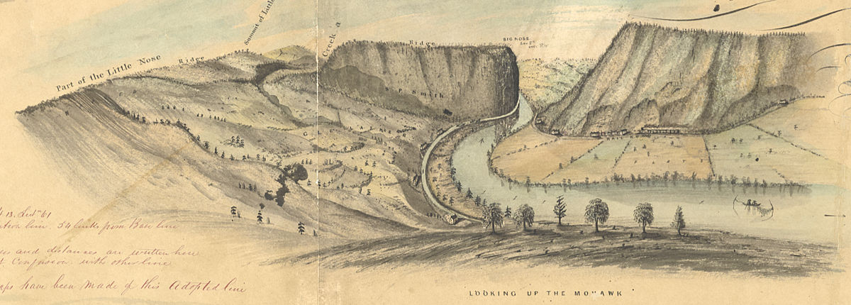
This Holmes Hutchinson 1833 survey map precisely locates the path of the original Erie Canal and the Mohawk River channel. This is the area that will be depicted in the foreground of our scene. As with other 19th-century survey maps, this one identifies the cliff south of the canal as Big Nose. (New York State Archives)
The map shown here locates the foreground of the scene, so it and its neighbors will be used to help reconstruct the area as it would have appeared in the early 19th century.
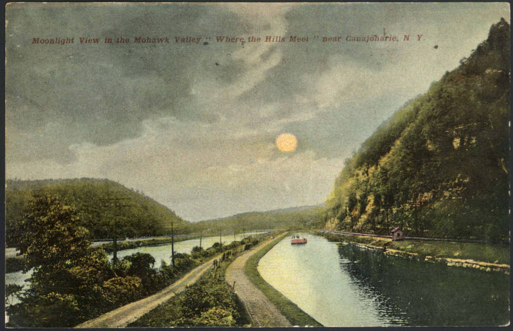
Several postcards, printed in the early 1900s, also survive. The original Erie Canal was long gone by then, superseded by the mid-19th-century First Enlargement. But they depict the Noses and Mohawk River before the final Barge Canal enlargement and the incursion of the New York State Thruway, both of which dramatically altered the topography of this historic corridor.
An early 20th-century postcard presents a romantic, hand-tinted view of the Enlarged Erie Canal at The Noses. (“Moonlight View in the Mohawk Valley,” Madden Collection, The Canal Society of New York State.)